Golden Age of Maritime Maps: When Europe Discovered the World - Hardcover
Zu dieser ISBN ist aktuell kein Angebot verf�gbar.
Alle Exemplare der Ausgabe mit dieser ISBN anzeigen:
Book by Hofmann Catherine Richard Helene Vagnon Emmanuelle
Die Inhaltsangabe kann sich auf eine andere Ausgabe dieses Titels beziehen.
Cr�ticas:
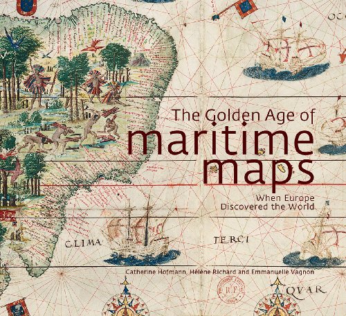
The color reproductions are excellent, and the maps chosen here are both aesthetically beautiful and historically interesting.--ProtoView (09/01/2014) Beautifully designed... it is difficult to not pick it up and be sucked into this historical journey of the golden age of mapmaking that told the story of European exploration around the world. You will truly find a new appreciation for those who traveled by land and sea without the aid of modern technologies and get a deeper sense of their inner thinking of what the world was like and just how imaginative people truly are.-- (04/29/2014) (star review) In the closing centuries of Europe's medieval age, that backward, isolated continent belatedly turned its gaze outward in search of trade and conquest. From that era of discovery came the Portolan charts, precursors of modern maps. Reproduced here in lavish full-color plates, this display of Portolan maps, many preserved at the National Library of France, documents Europe's expanding consciousness, its fumbling from blinkered ignorance to illumination and brief global dominance. The authors provide the historical context for these documents; the main body of the text is organized geographically, from the Mediterranean--so long the focus of insular European civilization--to the lands across the Atlantic and finally the traditional centers of human civilization on the far side of the Indian Ocean. Also included are appendices ranging from a lengthy bibliography to a full accounting of authors and photographers. From their roots in the 13th century to final decline in the 17th century, Portolan maps enshrined knowledge in works of magnificent artistry; the text and the high-resolution photographs document this flowering of creativity and curiosity. The work stands as one of scholarly love, like the maps themselves a grand partnership between abstract knowledge and concrete images.-- (12/16/2013) Portolan charts, so called from the Italian porto lano, meaning "related to ports or harbours," were created during the 12th century. They were drawn on parchment and crisscrossed with lines indicating compass directions for ports and anchorages and were used by Europeans exploring the world up until the 18th century. Not only used as navigational aids by those afloat they were also produced for wealthy sponsors in the form of illuminated images to illustrate economic and political interests of the major European sea powers. This book takes stock of the state of knowledge on these maps... Hofmann, Richard and Vagnon have carried out an amazing task bringing together this collection of 300 high quality illustrations from a multitude of sources including the National Library of France which holds 500 examples of exceptional quality.-- (06/01/2014) A must-have for anyone interested in cartography, especially in the Age of Exploration. The detail is great and allows the reader a close-up view of maps from the time period. In addition, the authors have highlighted sections of maps, for an even closer view. A great reference book!-- (06/01/2014) (Best Book of 2013: Non-Fiction) This is much more than a book of maritime maps. It is, in essence, a book of the art and charts of the European maritime community between the 13th and 18th centuries and it's a wonderful thing, indicating magical lost and imagined places as well as what was known of the world at the time. I think I'll be "reading" this one forever.-- (01/03/2014) This work is for the maritime enthusiast. Included are essays by a number of European authorities who elaborate upon locations, styles, and evolution of portolan charts from the late Middle Ages to the Age of Discovery. The early portolans were 12th-century parchment charts that initially described coastlines, ports, and havens, with special reference to the Mediterranean. Those charts were transformed as shipping took to the oceans of the world toward the end of the Middle Ages... A glossary and list of exhibit pieces conclude a work of special interest to the historians of cartography. Color maps and other illustrations are a feature of this work. Recommended. All levels/libraries.-- (05/01/2014)
Rese�a del editor:
'Portolan charts', so called from the Italian adjective portolano, meaning 'related to ports or harbours', were born during the 12th century in the maritime community. These charts, drawn on parchment and crisscrossed with lines referring to the compass directions, indicated the succession of ports and anchorages along the shores, and were used by European sailors exploring the world up until the 18th century. Not only used as navigational instruments on boats, they were also produced for wealthy sponsors in the form of illuminated images of the world, to illustrate the economic and political interests of the major European sea powers. This book takes stock of the state of knowledge on these maps, bringing together contributions from a dozen European specialists, who trace the history and diversity of styles and places of production of these charts. This type of mapping is approached from three angles. The first part, 'The Mediterranean', refers to the manufacture and use of the first charts, centered on the Mediterranean, and the persistence of this tradition in the Mediterranean basin until the 18th century. The second part, 'The Open Sea', shows how these regional charts have evolved from a technical and iconographical point of view at the time of the great European voyages, in order to include the oceans and new worlds. The third part, 'The Indian Ocean', shows how these charts, in a maritime area where ancient civilizations coexisted, were dependent on other cartographic traditions (ancient, Arab, Asian) before joining the information reported by Portuguese sailors and European trading companies in the modern era.
��ber diesen Titel� kann sich auf eine andere Ausgabe dieses Titels beziehen.
- VerlagFirefly Books Ltd
- Erscheinungsdatum2013
- ISBN 10 1770852387
- ISBN 13 9781770852389
- EinbandTapa dura
- Anzahl der Seiten256
- Bewertung
Beste Suchergebnisse beim ZVAB

Beispielbild f�r diese ISBN
The Golden Age of Maritime Maps : When Europe Discovered the World
Verlag:
Firefly Books, Limited
(2013)
ISBN 10: 1770852387
ISBN 13: 9781770852389
Gebraucht
Hardcover
Anzahl: 1
Anbieter:
Bewertung
Buchbeschreibung Zustand: Very Good. Used book that is in excellent condition. May show signs of wear or have minor defects. Artikel-Nr. 6297068-6
Weitere Informationen zu diesem Verk�ufer | Verk�ufer kontaktieren
Gebraucht kaufen
EUR 10,31
W�hrung umrechnen
Beispielbild f�r diese ISBN
Golden Age of Maritime Maps: When Europe Discovered the World
Verlag:
Firefly Books
(2013)
ISBN 10: 1770852387
ISBN 13: 9781770852389
Gebraucht
Paperback
Anzahl: 2
Anbieter:
Bewertung
Buchbeschreibung Paperback. Zustand: Very Good. The book has been read, but is in excellent condition. Pages are intact and not marred by notes or highlighting. The spine remains undamaged. Artikel-Nr. GOR008268328
Weitere Informationen zu diesem Verk�ufer | Verk�ufer kontaktieren
Gebraucht kaufen
EUR 7,19
W�hrung umrechnen
Foto des Verk�ufers
Golden Age of Maritime Maps: When Europe Discovered the World
Verlag:
Firefly Books Ltd
(2013)
ISBN 10: 1770852387
ISBN 13: 9781770852389
Gebraucht
Hardcover
Anzahl: 1
Anbieter:
Bewertung
Buchbeschreibung Zustand: Good. Most items will be dispatched the same or the next working day. Artikel-Nr. wbs4685613016
Weitere Informationen zu diesem Verk�ufer | Verk�ufer kontaktieren
Gebraucht kaufen
EUR 7,05
W�hrung umrechnen
Beispielbild f�r diese ISBN
The Golden Age of Maritime Maps: When Europe Discovered the World
Verlag:
Firefly Books Ltd
(2013)
ISBN 10: 1770852387
ISBN 13: 9781770852389
Gebraucht
Hardcover
Anzahl: 1
Anbieter:
Bewertung
Buchbeschreibung Hardcover. Zustand: Very Good. ALL ITEMS ARE DISPATCHED FROM THE UK WITHIN 48 HOURS ( BOOKS ORDERED OVER THE WEEKEND DISPATCHED ON MONDAY) ALL OVERSEAS ORDERS SENT BY TRACKABLE AIR MAIL. IF YOU ARE LOCATED OUTSIDE THE UK PLEASE ASK US FOR A POSTAGE QUOTE FOR MULTI VOLUME SETS BEFORE ORDERING. Artikel-Nr. mon0000896847
Weitere Informationen zu diesem Verk�ufer | Verk�ufer kontaktieren
Gebraucht kaufen
EUR 7,19
W�hrung umrechnen
Beispielbild f�r diese ISBN
The Golden Age of Maritime Maps: When Europe Discovered the World
Verlag:
Firefly Books
(2013)
ISBN 10: 1770852387
ISBN 13: 9781770852389
Gebraucht
Hardcover
Anzahl: 1
Anbieter:
Bewertung
Buchbeschreibung Zustand: Used - Very Good. Cloth, dj. Slight shelf wear. Very Good. Artikel-Nr. SON000046921
Weitere Informationen zu diesem Verk�ufer | Verk�ufer kontaktieren
Gebraucht kaufen
EUR 28,63
W�hrung umrechnen