Gesamtpreis (1 Artikel Artikel):
Versandziel:

Topographical Dictionary Ireland (22 Ergebnisse)
Direkt zu den wichtigsten Suchergebnissen
Produktart
- Alle Produktarten
- Bücher (21)
- Magazine & Zeitschriften
- Comics
- Noten
- Kunst, Grafik & Poster
- Fotografien
- Karten (1)
-
Manuskripte &
Papierantiquitäten
Zustand
Einband
Weitere Eigenschaften
Gratisversand
Land des Verkäufers
Verkäuferbewertung
-

hardcover. Zustand: Good. minor wear and creasing missing dust jacket.
-

A Topographical Dictionary Of Ireland
Verlag: Legare Street Press, 2022
ISBN 10: 1015672337ISBN 13: 9781015672338
Buch
Gebunden. Zustand: New.
-
Zustand: Poor. Volumes 1, 2. This is an ex-library book and may have the usual library/used-book markings inside.This book has hardback covers. In poor condition, suitable as a reading copy. No dust jacket. Folio size. Cloth, pattern boards. Front cover of Volume 1 not present. Front cover of Volume 2 detached but present. Page edges age worn. Spine cover not present. Please note the Image in this listing is a stock photo and may not match the covers of the actual item,5250grams, ISBN:
-
A Topographical Dictionary of England; A Topographical Dictionary of Ireland; A Topographical Dictionary of the Dominion of Wales
Verlag: Longman, Hurst, Rees, and Orme; Printed for the Author, by W. Bulmer; William Miller 1808-1811, London, 1808
Erstausgabe
Leather. Zustand: Very Good. None (illustrator). First edition. Four first edition volumes of English antiquary and librarian Sir Nicholas Carlisle's impressively detailed topographical dictionary of the British Isles. Three works by the prominent English antiquary bound in four volumes.Present here are:The scarce two volume first edition of the 'Topographical Dictionary of England', published in 1808. Alphabetically arranged, the work provides names of the several cities, towns, parishes, tythings, townships and hamlets within each county in England.Each volume retaining half title.The very scarce 1810 first edition of the 'Topographical Dictionary of Ireland'. Retaining the original half title.The 1811 first edition of 'A Topographical Dictionary of the Dominion of Wales'. Retaining the original half title.This work eventually extended to six volumes, with two volumes dedicated to Scotland published in 1813.With armorial bookplates to front pastedowns.A smart set of this richly detailed work. Rebacked, in quarter cloth bindings retaining the original calf boards. Rubbing to board perimeters. Head of rear joint of volume I and entirety of front joint starting, with boards a touch tender. Tail of front joint of volume II starting and slightly tender. Rear joint of Ireland volume starting, but firmly held. Front joint of Wales strained and a touch tender. Internally, firmly bound. Pages a touch age toned, with the odd spot. Very Good. book.
-
A Topographical Dictionary of Ireland . Being a continuation of the Topography of the United Kingdom of Great Britain and Ireland.
Verlag: British Library, Historical Print Editions, 2011
ISBN 10: 124160794XISBN 13: 9781241607944
Buch
Zustand: New. KlappentextbTitle:/b A Topographical Dictionary of Ireland . Being a continuation of the Topography of the United Kingdom of Great Britain and Ireland.br/br/bPublisher:/b British Library, Historical Print Editionsbr/br/The British Libr.
-
A TOPOGRAPHICAL DICTIONARY OF THE UNITED KINGDOM.in England, Wales, Scotland, Ireland and the Small Islands Dependent with forty-seven Maps
Verlag: Whittaker (Geo. B), London, 1825
Anbieter: Old Hall Bookshop, ABA ILAB PBFA BA, Brackley, Vereinigtes Königreich
Verbandsmitglied: ABA ILAB PBFA
Bewertung:

Cloth. Zustand: Good. No Jacket. xxiv, 865 pp, 1p addendum,(England and Wales) 152 pp,Scotland) 40 pp, (Ireland), 46 folding country and county maps,(note: Wales is on 1 map, not 2, as stated in list of contents) recent brown cloth, new endpapers, Geo. B. Whittaker, London, 1825. The book has been recently rebound with new endpapers. No pages present before the folding map of the United Kingdom which faces the title page. This map and the title page have some offsetting. Otherwise a very sound copy with all maps present and, apart from an occasional mark or stain, in very good condition. Size: 9 x 5.8 Ins.
-
A Topographical Dictionary of Ireland Exhibiting the Names of the Several Cities, Towns, Parishes and Villages, With the Barony, County, and Province
Verlag: WENTWORTH PR, 2016
ISBN 10: 1371078238ISBN 13: 9781371078232
Buch
Zustand: New.
-

Cassell\ s Gazetteer of Great Britain and Ireland: Being a Complete Topographical Dictionary of the United Kingdom With Numerous Illustrations and Six
Verlag: LIGHTNING SOURCE INC, 2015
ISBN 10: 134145116XISBN 13: 9781341451164
Buch
Gebunden. Zustand: New.
-
TOPOGRAPHICAL DICTIONARY OF THE UNITED KINGDOM: CONTAINING EVERY CITY, TOWN, VILLAGE, HAMLET, PARISH, DISTRICT, OBJECT AND PLACE IN ENGLAND, WALES, SCOTLAND, IRELAND.
Verlag: Whittaker,, London,, 1839
Hardcover. Zustand: Good. Fifth Edition. Hardback. No Dust Jacket. Very large 8vo. pp 1053; 152; 8. Original publisher's green cloth spine over marbled boards, lettered black on spine label. 5th edition. 46 maps, including frontispiece, some folding. Wales map is on one large folding page not two. Some rubbing and chipping to marbled boards and darkening to spine label, otherwise sound, used, near very good with clean text.
-
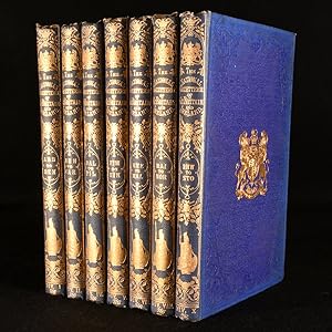
A Topographical Dictionary of Great Britain and Ireland, Compiled from Local Information, and the Most Recent and Official Authorites [3 Volume Set]
Verlag: Chapman & Hall, London, 1831
Hard Cover. Zustand: Good. No Jacket. Hall, Sidney (illustrator). Hardbacks, half-calf bindings. 3 volume set. xx, 759pp, 45pp ; 875pp ; 874pp, 20pp, 88pp. Complete with 54 folding county maps. Some browing and off-setting to maps. Split across spine of volume 2, binding loose with front board very nearly detached. Extremities slightly worn. Previous owner's bookplate to front pastedowns. Occasional grubby mark to edges and contents. (p22).
-

A Topographical Dictionary of the Dominion of Wales . Being a continuation of the Topography of the United Kingdom of Great Britain and Ireland.
Verlag: British Library, Historical Print Editions, 2011
ISBN 10: 1241607966ISBN 13: 9781241607968
Buch
Zustand: New. KlappentextbTitle:/b A Topographical Dictionary of the Dominion of Wales . Being a continuation of the Topography of the United Kingdom of Great Britain and Ireland.br/br/bPublisher:/b British Library, Historical Print Editionsbr/br/Th.
-
Zustand: Sehr gut. 572 Seiten Gepflegter, sauberer Zustand. 30305819/2 Altersfreigabe FSK ab 0 Jahre Taschenbuch, Größe: 15.2 x 2.9 x 22.9 cm.
-
A Topographical Dictionary of Ireland, Comprising the Several Counties, Cities, Boroughs, Corporate, Market and Post Towns, Parishes and Villages with Historical and Statistical Descriptions (Volume 1-2)
Verlag: S. Lewis & Co, 1837
Zustand: Good. Volume 1-2. This is an ex-library book and may have the usual library/used-book markings inside.This book has hardback covers. With usual stamps and markings, In good all round condition. No dust jacket. Half calf large octavo with gold stamped lettering and bands on spine, raised bands, worn cover scuffed edges and corners, marbled end pages, marbled page ends. Clear inside of markings. Please note the Image in this listing is a stock photo and may not match the covers of the actual item,5450grams, ISBN:
-
A Topographical Dictionary of Scotland, and of the Islands in the British Seas . Being a continuation of the Topography of the United Kingdom of Great Britain and Ireland.
Verlag: British Library, Historical Print Editions, 2011
ISBN 10: 1240923902ISBN 13: 9781240923908
Buch
Zustand: New. KlappentextbTitle:/b A Topographical Dictionary of Scotland, and of the Islands in the British Seas . Being a continuation of the Topography of the United Kingdom of Great Britain and Ireland.br/br/bPublisher:/b British Library, Histor.
-
A Topographical Dictionary of the United Kingdom; Containing Every City, Town, Village, Hamlet, Parish, District, Object, and Place in England, Wales, Scotland, Ireland, and the Small Islands Dependent
Verlag: Geo. B. Whittaker, London, 1825
Leather. Zustand: Good. Not Stated (illustrator). An uncommon edition of this popular topographical dictionary of the United Kingdom, with numerous maps. An uncommon new edition. In a full calf binding with gilt detail, and new endpapers. With a folding map frontispiece, a further six folding maps, and thirty-nine full-page maps. Collated complete. Wales is on one plate, not two as stated in the list of maps, as is common for this edition. A comprehensive topographical dictionary of England, Wales, Scotland and Ireland, from the early nineteenth century. Containing every city, town, village, hamlet, parish, and district. Benjamin Pitts Capper was a British gazetteer publisher. His best known work was this topographical dictionary, which was published in over twenty different editions. In a full calf binding. Externally, a trifle rubbed. Rubbing to the extremities. Fading to the spine. Marks to the boards. Crack to the upper rear board. Front hinge is starting but still firm. Light marks to the paste-downs and free endpapers. Internally, binding slightly strained but still firm. Pages lightly age-toned to the edges, otherwise generally bright and clean. Spotting and cockling to the frontispiece map. Loss to the upper title page. Some offsetting and scattered marks to the title page. Scattered spots throughout, heavier to the plates. Occasional offsetting on the pages facing the plates. Scattered handling marks and the odd ink mark. Ink mark to the map of Essex. Good. book.
-
A Topographical Dictionary of Scotland, and of the Islands in the British Seas . Being a continuation of the Topography of the United Kingdom of Great Britain and Ireland. Vol. II.
Verlag: British Library, Historical Print Editions, 2011
ISBN 10: 124150332XISBN 13: 9781241503321
Buch
Zustand: New. KlappentextbTitle:/b A Topographical Dictionary of Scotland, and of the Islands in the British Seas . Being a continuation of the Topography of the United Kingdom of Great Britain and Ireland.br/br/bPublisher:/b British Library, Histor.
-
A Topographical Dictionary of the United Kingdom; Compiled from Parliamentary an other authentic documents and authorities; containing geographical, topographical & statistical accounts of every district, object and place in England, Wales, Scotland, Ireland, and the various small islands of the British Empire. Accompanied by Forty-Six Maps, Drawn Purposley for this Work, on an original plan.
Verlag: London, Richard Philips, 1808, 1808
Anbieter: PROCTOR / THE ANTIQUE MAP & BOOKSHOP, DORCHESTER, Vereinigtes Königreich
Verbandsmitglied: PBFA
Bewertung:
Hardback, 8.5 x 5 inches. In full tree calf leather fine binding, black leather spine label lettered in gilt, with gilt banding and decoration. Plain endpapers and edges. In very good condition. Corners slightly bumped with some slight rubbing to edges and ends of spine. Bookplate to front ?Will. Bridges Neynce, Esq.? Front free endpaper removed. A couple of minor light spots, some minor handling marks else pages and maps all very clean and bright. Else a very clean and tight copy. Unpaginated. Illustrated with 46 hand-coloured engraved maps (some folding).
-
A Topographical Dictionary Of The United Kingdom; Compiled From Parliamentary, And Other Authentic Documents And Authorities; Containing Geographical, Topographical, & Statistical Accounts Of Every District, Object, And Place In England, Wales, Scotland, Ireland, And Various Small Islands Dependant On The British Empire. Accompanied By Forty-Six Maps, drawn purposely for this work, on an original plan
Verlag: Published by Richard Phillips, London, 1808
Karte Erstausgabe
, xiv, unpaginated, approx 1092 pages, 46 hand-coloured maps as called for on title page but Wales was printed on 1 map not 2, includes folding map of British Isles as frontispiece, double-column text First Edition , edges of boards and spine rubbed, few light scuffs to boards, spine slightly dulled and darkened in places, splits at upper and lower joints with front board a little loose, pages and plates clean, in good+ condition , full tan calf with gilt ruling and blindstamped floral borders, gilt titles on red leather spine panel, gilt decorated compartments, 5 raised bands, marbled edges Octavo Hardback ISBN:
-
Illustrated with Coloured Quarto Maps. The National Gazetteer of Great Britain and Ireland; Or, Topographical dictionary of the British Islands. Comprising above 30,000 names of towns, villages, parishes, hamlets, castles, seats, and other natural or political divisions; With a description of their churches, schools, antiquities, manufactures, progress, railways, etc., Compiled from the most recent and trustworthy sources, and corrected by local verification.
Verlag: Virtue & Co., London, 1868
Cloth. Zustand: Very Good. Not Stated (illustrator). A very scarce collection of seven volumes from the National Gazetteer series, with over 40 folding colour maps. In the publisher's original cloth binding. Six folding colour maps to each volume, apart from Volume VII, which has five. Forty-one folding colour maps overall. Two engraved title pages to Volume I and an engraved title page to Volume VII. The National Gazetteer is a topographical dictionary detailing the towns, villages, parishes, hamlets, castles, institutions, antiquities and railways of Great Britain and Ireland. These are 7 of 12 volumes in the series, and contain: Volume I, Abb-Ben; Volume II, Ben-Car; Volume IV, Dal-Fil; Volume V, Fim-Hin; Volume VII, Kne-Mai; Volume VIII, Mai-Nor; and Volume X, Rhw-Sto. They are edited by Nicholas Esterhazy Stephen Armytage Hamilton (c.1831-1915). In publisher's original cloth binding. Each volume is externally smart, with a little wear to the extremities and head and tail of the spine. Their spines are slightly faded and boards a little soiled. Small stains to the front boards of Vol IV, VII and VIII, and to the rear boards of Vol V and X. Gilt crest is still bright on most. Internally, the bindings of all volumes are slightly strained in places but remain firm. Pages are generally bright and clean, with the odd spot to the first and last few pages. Very Good. book.
-
A Topographical Dictionary of Ireland, Comprising the Several Counties; Cities; Boroughs; Corporate, Market, and Post Towns; Parishes; Villages; With Historical and Statisical Descriptions: Embellished with Engravings of the Arms of the Cities, Bishoprics, Corporate Towns, and Boroughs; and of the Seals of the Several Municipal Corporations. By Samuel Lewis. / Second Edition. / [ATLAS VOLUME:] Lewis?s Atlas comprising the Counties of Ireland and a general Map of the Kingdom.
Verlag: Samuel Lewis c. 1846-7., London, 1846
Anbieter: Alexandre Antique Prints, Maps & Books, Toronto, ON, Kanada
Bewertung:

Edition : Second Edition., Contemporary full blind-stamped cloth boards, text volumes with flat cloth spine in five compartments of gilt bands, gilt text on two, three and five; atlas volume with flat cloth spine in five compartments, gilt text on one. , In protective clear wrappers., Size : Large 4to. , Complete with 33 original outline-coloured maps, 32 of Irish counties and one folding map of Ireland as a whole, as well as the engraved title and engraved contents list., Volume : Three volumes (two text, P. Volume 1. (4), title, blank, preface iii-vi, 1-696, (4); Volume 2. (4), title, blank, 1-704, (4); Atlas. (4), engraved title, blank, contents, blank, 33 maps, (4). Minor chipping to the head and tail of spines, edges and corners bumped, map of Ireland with small tear extending from gutter inwards, not affecting image. Otherwise a very good copy, the text and the map plates especially are in very good condition, generally clean and crisp.
-
A TOPOGRAPHICAL DICTIONARY OF IRELAND COMPRISING THE SEVERAL COUNTIES, CITIES, BOROUGHS, CORPORATE, MARKET, AND POST TOWNS, PARISHES, AND VILLAGES, WITH HISTORICAL AND STATISTICAL DESCRIPTIONS; EMBELLISHED WITH ENGRAVINGS OF THE ARMS OF THE CITIES, BISHOPRICKS, CORPORATE TOWNS, AND BOROUGHS; AND OF THE SEALS OF THE SEVERAL MUNICIPAL CORPORATIONS : WITH AN APPENDIX, DESCRIBING THE ELECTORAL BORDERS OF THE SEVERAL BOROUGHS, AS DEFINED BY THE ACT OF THE 2d & 3d OF WILLIAM IV. (TWO VOLUMES)
Verlag: S. Lewis & Co, London, England, 1837
Anbieter: Aardvark Rare Books, ABAA, EUGENE, OR, USA
Verbandsmitglied: ABAA CBA ILAB IOBA
Bewertung:
Leather-bound. Zustand: Very Good. Matching two volume set: Folio, 12.75 in. x 10 in. Rebound in brown half morocco over marbled boards. Five riaised bands to spines. Gilt title and band lines on black panel to spines. Very light shelfwear to bottom edges. Newer endpapers. Occasional light spotting throughout both volumes. Unmarked, clean interiors. Volume I: pp. lxviii, 675. Light spotting to title page. Volume II: pp. 737, [4].
-
A topographical Dictionary of Ireland. Comprising the Counties, Cities, Boroughs, Corporate, Market, and Post Towns, Parisches and Villages with historical and statistical descriptions. Embellished with Engravings of the Arms of the Cities, Bishopricks, Corporate Towns, and Boroughs; and of the Seals of the several Municipal Corporations: With an Appendix, describing the electoral Boundaries of the several Boroughs, as defined by the Act od the 2d & 3d of William IV. In Two Volumes. Band 3: Atlas of Ireland. 3 Bände (komplett).
Verlag: Galway, Kenny's Bookshop., 1995
Buch Erstausgabe
4°. 31 x 25 cm. LXVIII, 675 und 737 Seiten, [35] Blatt. Original-Leinenbände mit goldgeprägten Deckel- und Rückentiteln im Original-Pappschuber. 1. Auflage. Englischsprachige Ausgabe. Nachdruck der Ausgabe London, 1837. Pappschuber leicht berieben. Sehr gutes Exemplar. First edition. English language edition. Original cloth bindings with gilt embossed title on cover and spine in original cardboard slipcase. Reprint of the edition London, 1837. Cardboard slipcase slightly rubbed. Fine copy. Sprache: englisch.

![Bild des Verkäufers für A Topographical Dictionary of Great Britain and Ireland, Compiled from Local Information, and the Most Recent and Official Authorites [3 Volume Set] zum Verkauf von Besleys Books PBFA](https://pictures.abebooks.com/inventory/md/md10746366619.jpg)