
Gesamtpreis (1 Artikel Artikel):
Versandziel:

West Coast Scotland Pilot (19 Ergebnisse)
Direkt zu den wichtigsten Suchergebnissen
Produktart
- Alle Produktarten
- Bücher (19)
- Magazine & Zeitschriften
- Comics
- Noten
- Kunst, Grafik & Poster
- Fotografien
- Karten
-
Manuskripte &
Papierantiquitäten
Zustand
- Alle
- Neu
- Antiquarisch/Gebraucht
Einband
Weitere Eigenschaften
- Erstausgabe (1)
- Signiert
- Schutzumschlag
- Angebotsfoto (6)
Land des Verkäufers
Verkäuferbewertung
-

West Coast of Scotland Pilot (Admiralty Sailing Directions)
Verlag: United Kingdom Hydrographic Office, 2008
ISBN 10: 0707718252ISBN 13: 9780707718255
Buch
hardcover. Zustand: Used; Good. Dispatched, from the UK, within 48 hours of ordering. This book is in good condition but will show signs of previous ownership. Please expect some creasing to the spine and/or minor damage to the cover. Inscription on the first page, typically just a name but may include a dedication or a brief personal message.
-
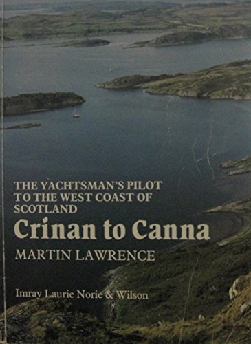
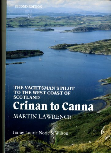
Crinan to Canna (The Yachtsman's Pilot to the West Coast of Scotland)
Verlag: Bluewater Books & Charts, 1994
ISBN 10: 0852882505ISBN 13: 9780852882504
Buch
Paperback. Zustand: Good. The book has been read but remains in clean condition. All pages are intact and the cover is intact. Some minor wear to the spine.
Mehr Angebote von anderen Verkäufern bei ZVAB
Gebraucht ab EUR 5,41
-

Clyde to Colonsay (Yachtsman's Pilot to the West Coast of Scotland)
Verlag: IMRAY, LAURIE, NORIE WILSON, 1989
ISBN 10: 0852881320ISBN 13: 9780852881323
Buch
Paperback. Zustand: Very Good. The book has been read, but is in excellent condition. Pages are intact and not marred by notes or highlighting. The spine remains undamaged.
Mehr Angebote von anderen Verkäufern bei ZVAB
Gebraucht ab EUR 9,36
-
Hardcover. Zustand: Very Good. West Coast of Scotland Pilot This book is in very good condition and will be shipped within 24 hours of ordering. The cover may have some limited signs of wear but the pages are clean, intact and the spine remains undamaged. This book has clearly been well maintained and looked after thus far. Money back guarantee if you are not satisfied. See all our books here, order more than 1 book and get discounted shipping.
-
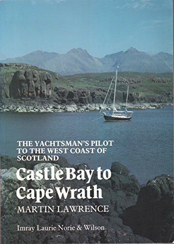
Castlebay to Cape Wrath (The Yachtsman's Pilot to the West Coast of Scotland)
Verlag: See notes, 1990
ISBN 10: 0852881444ISBN 13: 9780852881446
Buch
Paperback. Zustand: Very Good. The book has been read, but is in excellent condition. Pages are intact and not marred by notes or highlighting. The spine remains undamaged.
-
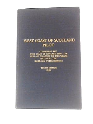
West Coast Of Scotland Pilot; Comprising The West Coast Of Scotland From The Mull Of Galloway To Cape Wrath Including The Inner And Outer Hebrides
Verlag: Hydrographic Department, Admiralty, 1958
Anbieter: World of Rare Books, Goring-by-Sea, SXW, Vereinigtes Königreich
Bewertung:

Zustand: Good. 1958. 10th Edition. 686 pages. No dust jacket. Blue cloth. Black and white photographic plates throughout. Binding remains firm. Pages and plates have light tanning and foxing throughout. Pencil mark to rear pastedown. Boards have moderate shelf-wear with bumping to corners and rubbing to surfaces. Slight crushing to spine ends. Light wear marks overall.
-
Crinan to Canna (Yachtsman's Pilot to the West Coast of Scotland)
Verlag: See notes, 1990
ISBN 10: 0852881436ISBN 13: 9780852881439
Buch
Paperback. Zustand: Very Good. The book has been read, but is in excellent condition. Pages are intact and not marred by notes or highlighting. The spine remains undamaged.
Mehr Angebote von anderen Verkäufern bei ZVAB
Gebraucht ab EUR 16,02
-
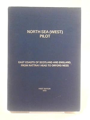
North Sea (West) Pilot - East Coasts of Scotland and England, from Rattray Head to Orford Ness ( No. 54 )
Verlag: Hydrographer of the Navy, 1973
Anbieter: World of Rare Books, Goring-by-Sea, SXW, Vereinigtes Königreich
Bewertung:
Erstausgabe
Zustand: Good. 1973. First Edition. 198 pages. No dust jacket. Blue cloth covered boards with gilt. Pages remain clear with minimal tanning and foxing. Binding remains firm. Boards have mild edge-wear with slight rubbing to surfaces. Mild crushing to spine ends. Book has a slight forward lean. Gilt lettering is bright and clear.
-
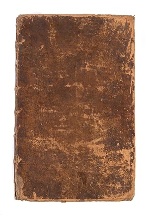
The English Pilot, for the Southern Navigation: describing the Sea-Coasts, Capes, Headlands, Bays, Roads, Harbours, Rivers and Ports: together with the Soundings, Sands, Rocks and Dangers on the Coast of England, Scotland, Ireland, Holland, Flanders, Spain, Portugal, to the Streight's-Mouth; with the Coasts of Barbary, and off to the Canary, Madeira, Cape de Verde and Western-Islands.
Erscheinungsdatum: 1758
Anbieter: Maggs Bros. Ltd ABA, ILAB, PBFA, BA, London, Vereinigtes Königreich
Verbandsmitglied: ABA ILAB PBFA
Bewertung:
Folio (475 x 305 mm), [ii], 96pp, 22 engraved charts, most double-page, two engraved text illustrations, many woodcut harbour charts and coastal profiles set in the text. London: Mount & Page [William and John Mount, Thomas Page (II) and Thomas (III)], Uncommon late printing of the 'English Pilot' volume for the 'Southern Navigation', for the use of mariners in European waters, covering the coasts from Scotland southwards, with the Atlantic coasts of Ireland, France and Spain round to the Straits of Gibraltar. This was the principal English pilot book for the region for the period. This copy was published during the Seven Years' War, when fears of a French invasion were at their height, and covers those areas most likely to be the scene of naval actions or landings. The chart composition of the book can vary between copies; this copy is without the chart of the Forth of Forth and two charts of the Dutch coast found in some editions, but has an additional chart of the 'Westerne Islands'. ESTC records three American locations; Adams and Waters add the National Maritime Museum and two further American locations.
-
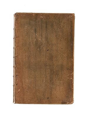
The Coasting Pilot. Describing the Sea-Coasts, Capes, Headlands, Soundings, Sands, Shoals, Rocks and Dangers. The Bays, Roads, Harbours, Rivers and Ports of England, Scotland, Holland, Zealand, Flanders and France. .'bound with: The English Pilot, for the Southern Navigation: describing the Sea-Coasts, Capes, Headlands, Bays, Roads, Harbours, Rivers and Ports: together with the Soundings, Sands, Rocks and Dangers on the Coast of England, Scotland, Ireland, Holland, Flanders, Spain, Portugal, to the Streight's-Mouth; with the Coasts of Barbary, and off to the Canary, Madeira, Cape de Verde and Western-Islands. .bound with: The English Pilot. Describing the Sea-Coasts, Capes, Head-Lands, Soundings, Sands, Shoals, Rocks and Dangers, the Bays, Roads, Harbours, Rivers and Ports in the Whole Northern Navigation; . describing the North Coast of England and Scotland, with the Islands of Orkney, Shetland, Lewis, Farro, Iceland, &c. The sea-coast of Flanders, Zealand, Holland, Germany, Denmark,
Erscheinungsdatum: 1759
Anbieter: Maggs Bros. Ltd ABA, ILAB, PBFA, BA, London, Vereinigtes Königreich
Verbandsmitglied: ABA ILAB PBFA
Bewertung:
London : Mount & Page, 1758; London : Mount & Page, 1758; London : Mount & Page, 1756; London : Mount & Page, 1753; London : Mount & Page, 1753; London : Mount & Page, 1755; London : Mount & Page, 1759. Apparently unique compilation of the six constituent volumes of the English Pilot bound in two, lacking all the inserted charts, but the text complete, retaining the engraved charts in the text (notably in the 'Fourth Book': Antigua, Barbados and Bermuda), with the woodcuts and engravings in fine original wash colour. There is no indication of the charts having been removed; it may be that they were originally bound separately or not purchased at all. The individual volumes of the English Pilot series were the best available English chart books for much of the eighteenth century. The series was begun by John Seller in 1671, with the Northern Navigation, and 1672, Southern Navigation and subsequently expanded by Seller, his successors and heirs with the Mediterranean Pilot (1677), West-India Pilot (1689), West African Pilot (1701) and Oriental Navigation (1703). As a working book, individual editions of the various volumes can be rare. This group, put together at the time of the Seven Years' War / French and Indian War contains several rare printings, but the real significance is the assemblage of the volumes together and the exceptional original colouring throughout, these volumes clearly intended for library use, hence the colouring and fine internal condition. Locations: Coasting Pilot (title-page only): ESTC N44114: only Folger Shakespeare English Pilot Southern: apparently unrecorded, but cf. ESTC N47593. Northern: unrecorded in ESTC. Mediterranean: ESTC N69402: recording the Yale and New York Public Library copies, to which can be added a copy in the National Maritime Museum. West Africa: unrecorded in ESTC; with a copy in the National Maritime Museum. Oriental Navigation: ESTC T218365: recording the Cambridge and National Maritime Museum copies. West India Navigation: ESTC N69401: recording only the Yale copy, with further copies in the Library of Congress and Dartmouth College Library.
-
[The English Pilot Parts I and III] The English Pilot for the Southern Navigation: Describing the Sea-Coasts, Capes, Headlands, Bays, Roads, Harbours, Rivers and Ports: together with the Soundings, Sands, Rocks and Dangers on the Coast of England, Scotland, Ireland, Holland, Flanders, Spain, Portugal, to the Streight's-Mouth; with the Coasts of Barbary, and off to the Canary, Madeira, Cape de Verde and Western Islands Shewing the Courses and Distances from on Place to another; The Setting of the Tides and Currents; the Ebbing and Flowing of the Sea, &c. The English Pilot. Part III. Describing The Sea-Coasts, Capes, Head-Lands, Bays, Roads, Harbours, Rivers and Ports; Together with the Soundings, Sands, Rocks and Dangers in the Whole Mediterranean Sea, Likewise The Courses and distances from on Place to another. The Setting of the Tides and Currents. The Ebbing and Flowing of the Sea. The Bearing, Distance and Prospects of the Land, and how they shew themselves at Sea. Carefully Correct
Verlag: J. Mount, and T. Page, London, 1771
Anbieter: Argosy Book Store, ABAA, ILAB, New York, NY, USA
Bewertung:
hardcover. Zustand: very good. Folio atlas. Two parts (I and III) bound in one volume, London: 1771. Part I: 46 pp of text; 22 double page and folding maps plus 2 small maps and many additional charts and views. Ink inscription on title page reads "1774 John Hamilton Ought This Book-Bought of James Alex.(?) Stewart". Stamped name in margin of one page of text. Part III: 43 pp of text; 17 double page or folding maps, 34 half page maps and numerous topographical and panoramic views. Ink inscription "John Hamilton" on title page. Stamped name on title page and two maps. Numerous woodcut elevations and additional engraved maps throughout both volumes. Rebound in blue bukram with gilt title stamped on spine. Stamp from G.H. Crawford Co. Bookbinders, Dec. 1955 on inside back free fly page. Light scattered foxing and a few stains throughout with more toning in the final 8 pages. Small chip to title page and one map. Small wormholes to a few maps. In general, maps are crisp and clean. Beautiful composite atlas with a series of stunning maps and charts and explicit sailing directions and notations. Part I has charts of the River Thames, Newcastle trade routes, the coastlines and various ports of England, Scotland, Ireland, Flanders and the Netherlands, France, Portugal, Spain, the Strait of Gibraltar, the Canary Islands and the Cape Verde Islands. Part III has maps and charts of the Mediterranean from the Strait of Gibraltar to the Levant including the Balearic Islands, southern France, the Barbary Coast, Corsica, Sardinia, Sicily, Malta, Venice and Greece. The "English Pilot" was a sea-chart atlas published in several editions from 1671 to 1803. The Mount family was active in publishing in various manifestations for many generations from the 1650s to 1800.
![Bild des Verkäufers für [The English Pilot Parts I and III] The English Pilot for the Southern Navigation: Describing the Sea-Coasts, Capes, Headlands, Bays, Roads, Harbours, Rivers and Ports: together with the Soundings, Sands, Rocks and Dangers on the Coast of England, Scotland, Ireland, Holland, Flanders, Spain, Portugal, to the Streight's-Mouth; with the Coasts of Barbary, and off to the Canary, Madeira, Cape de Verde and Western Islands Shewing the Courses and Distances from on Place to another; The Setting of the Tides and Currents; the Ebbing and Flowing of the Sea, &c. The English Pilot. Part III. Describing The Sea-Coasts, Capes, Head-Lands, Bays, Roads, Harbours, Rivers and Ports; Together with the Soundings, Sands, Rocks and Dangers in the Whole Mediterranean Sea, Likewise The Courses and distances from on Place to another. The Setting of the Tides and Currents. The Ebbing and Flowing of the Sea. The Bearing, Distance and Prospects of the Land, and how they shew themselves at Sea. Carefully Correct zum Verkauf von Argosy Book Store, ABAA, ILAB](https://pictures.abebooks.com/inventory/md/md3716837647.jpg)