Gesamtpreis (1 Artikel Artikel):
Versandziel:

blaeu jean (9 Ergebnisse)
Direkt zu den wichtigsten Suchergebnissen
Produktart
- Alle Product Types
- Bücher (6)
- Magazine & Zeitschriften
- Comics
- Noten
- Kunst, Grafik & Poster
- Fotografien
- Karten (3)
- Manuskripte & Papierantiquitäten
Zustand
Einband
Weitere Eigenschaften
- Erstausgabe (1)
- Signiert (1)
- Schutzumschlag
- Angebotsfoto (6)
Gratisversand
- Versand nach USA gratis
Land des Verkäufers
Verkäuferbewertung
-
Couverture rigide. Zustand: bon. R240153649: 1987. In-4. Relié. Bon état, Couv. convenable, Dos satisfaisant, Intérieur frais. 287 pages augmentées de trčs nombreuses cartes en noir et blanc hors texte. . . . Classification Dewey : 912-Atlas, cartes et plans.
-

Eloge de M. Michel, Directeur d\ Ecole Secondaire Et Membre de l\ Academie de Nancy, Par M. Blau, .
Verlag: HACHETTE LIVRE, 2019
ISBN 10: 2329284411ISBN 13: 9782329284415
Buch
Zustand: New.
-
![Bild des Verkäufers für [Portfolio]: Antique Maps of the World in Color zum Verkauf von Between the Covers-Rare Books, Inc. ABAA](https://pictures.abebooks.com/inventory/md/md31614799540.jpg)
[Portfolio]: Antique Maps of the World in Color
Verlag: Sterling Publishing House, Co., Inc, New York, 1960
Anbieter: Between the Covers-Rare Books, Inc. ABAA, Gloucester City, NJ, USA
Verbandsmitglied: ABAA ESA ILAB IOBA
Bewertung:

Erstausgabe
Unbound. Zustand: Very Good. Portfolio. Color facsimiles of 36 historical maps. Each map measures approximately 12" x 9", printed on 17" x 11˝" paper with descriptive text in the left margin. Housed with a title page sheet and unprinted top sheet in a four-fold chemise. Unprinted topsheet sunned at the edges, first two leaves with some very light toning and a couple of tiny corner creases; the maps are otherwise bright and fine. The chemise is good only with toning, wear, and soil, and a 1" creased tear on the cover panel. A nice production, and the chemise has done its job, keeping the maps bright and fresh.
-
"Dioecese de Rheims et le pais de Bethel" - Reims Rethel Laon Epernay Chalons-en-Champagne France Frankreich carte
Verlag: Amsterdam ca. 1640., 1640
Anbieter: Antiquariat Steffen Völkel GmbH, Seubersdorf, Deutschland
Bewertung:
Karte
Große altkolorierte Kupferstich-Karte von ca. 1640. -- Mit lateinischem Text auf der Rückseite. -- Blatt-Maße: ca. 50 x 59 cm. -- gut erhalten. || Large old colored map from ca. 1640. With Latin text on verso. -- in good condition. || Dies ist ein Original! - Kein Nachdruck! - Keine Kopie! -- This is an original! - No copy! - No reprint! la.
-
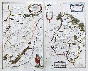
"Descriptio Veromanduorum. Gallice Vermandois / Gouvernement de la Cappelle" - Vermandois Saint-Quentin La Capelle Vervins Marle Aisne Hauts-de-France France Frankreich carte
Verlag: Amsterdam ca. 1640., 1640
Anbieter: Antiquariat Steffen Völkel GmbH, Seubersdorf, Deutschland
Bewertung:
Karte
Große altkolorierte Kupferstich-Karte von ca. 1640. -- Zwei Karten auf 1 Blatt. -- Mit lateinischem Text auf der Rückseite. -- Blatt-Maße: ca. 50 x 59 cm. -- etwas fleckig, sonst gut erhalten. || Large old colored map from ca. 1640. With Latin text on verso. -- Two maps on one sheet. -- with some staining, otherwise in good condition. || Dies ist ein Original! - Kein Nachdruck! - Keine Kopie! -- This is an original! - No copy! - No reprint! la.
-

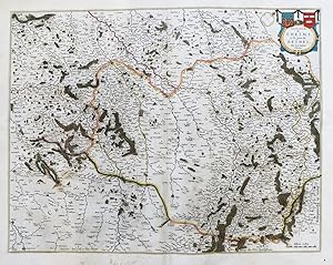
PERCHENSIS COMITATUS. La Perche comte. COMITATUS BLESENSIS. Blaisois. Auctore Ioanne Temporio.
Verlag: S/data. [[J. Janssonius. Amsterdam, ca. 1645, 1645
Anbieter: Libreria Anticuaria Farré, Barcelona, BARCE, Spanien
Bewertung:

.] Dos mapas grabados a color, uno de 39 x 23 y otro de 39 x 26 cm, en una hoja de 49 x 58 cm. Varias restauraciones y pequeńas rasgaduras marginales. * El mapa de la zona de Le Perche (Francia, Normadía) fue ejecutado por Bleau y el de la zona de Blaisois, pertenece a la región Centro-Val de Loira. La escala que utiliza es la ?milliaria gallica? OCLC 884404627. Francia.
-
( Siege of Gravelines )
Verlag: Amsterdam, 1644
Anbieter: Antipodean Books, Maps & Prints, ABAA, Garrison, NY, USA
Verbandsmitglied: ABAA ANZAAB ESA ILAB
Bewertung:
Black & white. Title surrounded by cartouche. 20 1/2 x 16 1/2 with wide margins. Naval battle with the fort portrayed in what was Flanders, and is now part of France.
-
Nouveau Theatre d?Italie, ou Description Exacte de Ses Villes, Palais, Eglises, Principaux Edifices &c. TOME QUATRIEME contenant Rome Ancienne et Moderne?
Verlag: Rutgert Christophle Alberts., Hague [A La Haye], 1724
Anbieter: Alexandre Antique Prints, Maps & Books, Toronto, ON, Kanada
Bewertung:

Full original mottled calf boards, expertly rebacked to style. Spine with 7 raised bands, title lettered in gilt on red morocco label in 2nd compartment, remaining densely decorated in gilt detail. Gilt rolls on board edges. Marbled pasted and free endpapers. All edges red., Text in French. Joan Blaeu (1596-1673) was a Dutch cartographer and son of cartographer Willem Blaeu. Joan Blaeu studied law but in 1620 he joined his father in his cartographic business, together publishing Atlas Novus (Theatrum orbis terrarum, sive, Atlas novus) in 1635. After Willem died in 1638, Joan and his brother Cornelius took over the business, and Joan Blaeu became the official cartographer of the Dutch East India Company, as his father had been before him., Size : Tall Folio.(525 x 310 mm), Complete with 87 plates plus engraved title; many double-page or folding out. Title in red and black. French edition of the original Dutch atlas of Italian towns and cities produced by Pierre Mortier (circa 1704). , P: Blank (2). Engraved title. Blank. Title. Blank. Subscribers (4). Pp. I-XL. Courte Description de Chaque Monument?title. Blank. Table of plates (2). P. 1-14 [with 87 plates]. Blank (2). Very good example. Boards somewhat rubbed at extremities. Interior generally clean and crisp; occasional minor tears at edges; light dampstain at bottom of lower free endpaper. Pp. XXIV mispag. XXVI; plates 80-87 unnumbered. Volume 4 only, which is complete on Rome.
-
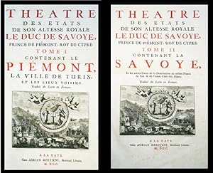
Théâtre des Etats de son Altesse Royale le Duc de Savoye, Prince de Piémont. Roy de Cypre. (Atlas en 2 volumes du Théâtre du Piémont et de la Savoye).
Verlag: A la Haye, Chez Adrian Moetjens, Marchand Libraire MDCC, 1700,, 1700
Anbieter: Harteveld Rare Books Ltd., Fribourg, Schweiz
Bewertung:
Signiert
imp. in-folio, (57.5x30 cm), Tome I : ?Contenant le Piémont, la Ville de Turin, et les lieux voisins. Traduit du Latin en François? (par Jacques Bernard), 65 cartes & vues sur planches / Tome II: ?Contenant La Savoye?, 69 cartes & vues sur planches. reliures originales hollandaises en plein veau, pičce d?ornement centrale or, dos ŕ nerfs ornés, tęte dorée, qqs restaurations aux coiffes et charničres. (59,5x38 cm,) Superbe exemplaire. ?Sans doute le plus beau livre ancien consacré aux Alpes de Savoie et du Piémont? (Perret).Premičre édition française, complčte de ses 134 planches de vues et de cartes gravées + 2 titres gravés + 4 portraits et une table généalogique double (comptée comme 2 planches) soit142 planches au total, toutes montées sur onglets. Superbe exemplaire d'un trčs beau tirage sur papier de grande qualité. L?ouvrage a été publié plusieurs fois entre 1682 et 1700, en italien, français, latin et en hollandais. Please notify before visiting to see a book. Prices are excl. VAT/TVA (only Switzerland) & postage. Koeman, volume IV-1, p. 461-467. This French edition has the same composition as the edition with Dutch text, published by Adr. Moetjens in 1697 (except the 3 adds on the family-tree of the Savoy with the last born: Philippe Joseph on the 6 May 1699?). (Complete copy with 142 plates with maps & views, many folded, text illustrated with engraved ornaments and tail-pieces, some signed by Bernard Picart); Perret, Regards sur les Alpes, p. 47, notice 7; Perret 487.