Gesamtpreis (1 Artikel Artikel):
Versandziel:

bradford thomas gamaliel (34 Ergebnisse)
Direkt zu den wichtigsten Suchergebnissen
Produktart
- Alle Produktarten
- Bücher (34)
- Magazine & Zeitschriften
- Comics
- Noten
- Kunst, Grafik & Poster
- Fotografien
- Karten
-
Manuskripte &
Papierantiquitäten
Zustand
Einband
Weitere Eigenschaften
- Erstausgabe
- Signiert
- Schutzumschlag
- Angebotsfoto (28)
Gratisversand
Land des Verkäufers
Verkäuferbewertung
-
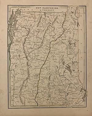
New Hampshire & Vermont
Verlag: Bradford, Thomas Gamaliel, Boston, 1835
Anbieter: Argosy Book Store, ABAA, ILAB, New York, NY, USA
Bewertung:

unbound. Zustand: very good. Map. Engraving with original hand outline coloring. Image measures 10" x 7.75". Nice map of New Hampshire and Vermont divided into counties. Details towns and waterways. Minor scattered foxing, mainly to margins. Small chip to left edge. T.G. Bradford (1802-1887) was a Boston based publisher. He worked as assistant editor of the American Encyclopedia before entering the field of map making.
-
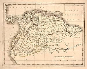
Colombia & Guiana
Verlag: W.D. Ticknor, Boston, 1835
Anbieter: Argosy Book Store, ABAA, ILAB, New York, NY, USA
Bewertung:
unbound. Zustand: very good. Map. Engraving with original hand outline. Image measures 7.75" x 10". From "A Comprehensive Atlas Geographical, Historical and Commercial". Minor discoloration in margins. T.G. Bradford (1802-1887) was a Boston based publisher. He worked as assistant editor of the American Encyclopedia before entering the field of map making.
-
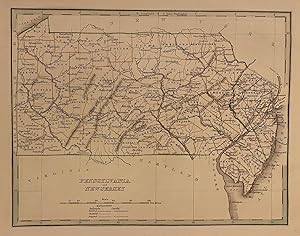
Pennsylvania and New Jersey
Verlag: Bradford, Thomas Gamaliel, Boston, 1835
Anbieter: Argosy Book Store, ABAA, ILAB, New York, NY, USA
Bewertung:
unbound. Zustand: very good. Map. Engraving with original hand outline coloring. Image measures 8" x 10". Great map of Pennsylvania and New Jersey divided into counties. Delineates towns, topography and waterways. Minor wear to edges. T.G. Bradford (1802-1887) was a Boston based publisher. He worked as assistant editor of the American Encyclopedia before entering the field of map making. He was best known for his 1835 "A Comprehensive Atlas: Geographical, Historical & Commercial" and his 1838 "Illustrated Atlas Geographical, Statistical and Historical of the United States and Adjacent Countries", both of which proved to be important contributions to American cartography.
-
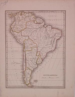
South America
Verlag: Bradford, Thomas Gamaliel, Boston, 1835
Anbieter: Argosy Book Store, ABAA, ILAB, New York, NY, USA
Bewertung:
unbound. Zustand: very good. G.W. Boynton & Co. (illustrator). Map. Engraving with original hand outline coloring. Image measures 10" x 7.75". Some foxing. T.G. Bradford (1802-1887) was a Boston based publisher. He worked as assistant editor of the American Encyclopedia before entering the field of map making.
-

New York
Verlag: T.G. Bradford, Boston, 1835
Anbieter: Argosy Book Store, ABAA, ILAB, New York, NY, USA
Bewertung:
unbound. G.W. Boynton (illustrator). Map. Engraving with original hand coloring. Image measures 7 3/4" x 10 1/8" Beautiful map of New York State divided by county, from the first edition of Bradford's "A Comprehensive Atlas". Cities, towns, major routes, rivers, railroads, and canals are labeled. In very good condition, with very faint scattered foxing and minor wear to margins not affecting the image. Thomas Gamaliel Bradford (1802-1887) was a Boston based publisher. He worked as assistant editor of the American Encyclopedia before entering the field of map making. He was best known for his important contributions to American cartography, the 1838 "Illustrated Atlas Geographical, Statistical and Historical of the United States and Adjacent Countries.".
-
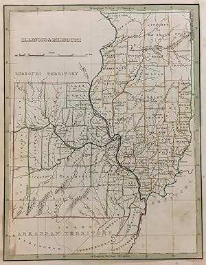
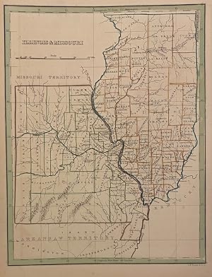
Illinois & Missouri
Verlag: Bradford, Thomas Gamaliel, Boston, 1835
Anbieter: Argosy Book Store, ABAA, ILAB, New York, NY, USA
Bewertung:
unbound. Map. Engraving with original outline coloring. Image measures 10" x 8". Charming map of Illinois and Missouri Territory, divided into counties showing town, geographical features and Indian tribes. Light scattered foxing. T.G. Bradford (1802-1887) was a Boston based publisher. He worked as assistant editor of the American Encyclopedia before entering the field of map making.
-
A Comprehensive Atlas : Geographical, Historical and Commercial (Classic Reprint)
Verlag: Forgotten Books, 2018
ISBN 10: 1397242973ISBN 13: 9781397242976
Buch
Zustand: Wie neu. Zustand: Wie neu | Seiten: 258.
-
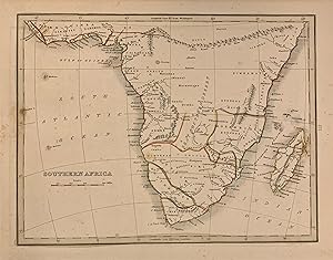
Southern Africa
Verlag: W.D. Ticknor, Boston, 1835
Anbieter: Argosy Book Store, ABAA, ILAB, New York, NY, USA
Bewertung:
unbound. Zustand: very good. Map. Engraving with original outline coloring. Image measures 7.5" x 10". Early map of South Africa with elevations shown pictorially. Tribal notations included along with major towns. Extends as far north as the fictional 'Mountains of Kong and Mountains of the moon. Thomas Gamaliel Bradford (1802-1887) was a Boston based publisher. He worked as assistant editor of the American Encyclopedia before entering the field of map making. He was best known for his important contributions to American cartography, the 1838 "Illustrated Atlas Geographical, Statistical and Historical of the United States and Adjacent Countries.".
-
Illinois & Missouri
Verlag: Bradford, Thomas Gamaliel, Boston, 1835
Anbieter: Argosy Book Store, ABAA, ILAB, New York, NY, USA
Bewertung:
unbound. Map. Engraving with original outline coloring. Image measures 10" x 8". Charming map of Illinois and Missouri Territory, divided into counties showing town, geographical features and Indian tribes. Light scattered foxing. T.G. Bradford (1802-1887) was a Boston based publisher. He worked as assistant editor of the American Encyclopedia before entering the field of map making.
-
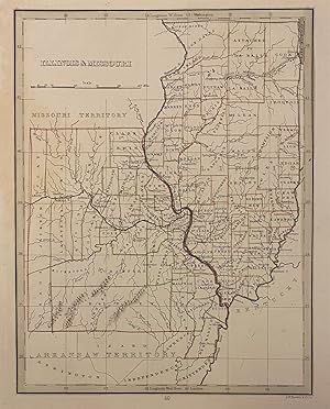
Illinois & Missouri
Verlag: Bradford, Thomas Gamaliel, Boston, 1835
Anbieter: Argosy Book Store, ABAA, ILAB, New York, NY, USA
Bewertung:
unbound. Map. Engraving with original outline coloring. Image measures 10" x 8". Charming map of Illinois and Missouri, divided into counties. Shows town, geographical features and Indian tribes. Light scattered foxing. T.G. Bradford (1802-1887) was a Boston based publisher. He worked as assistant editor of the American Encyclopedia before entering the field of map making. He was best known for his 1835 "A Comprehensive Atlas: Geographical, Historical & Commercial" and his 1838 "Illustrated Atlas Geographical, Statistical and Historical of the United States and Adjacent Countries", both of which proved to be important contributions to American cartography.
-
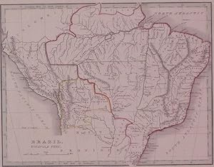
Brazil, Bolivia, & Peru
Verlag: Ticknor, W.D., Boston, 1835
Anbieter: Argosy Book Store, ABAA, ILAB, New York, NY, USA
Bewertung:
unbound. Zustand: very good. Map. Engraving with original color outline. Image measures 7.75" x 10". Brazil in 1835 from Guyana and Colombia in the north to Uruguay in the south and from Bolivia in the west to the Atlantic. T.G. Bradford (1802-1887) was a Boston based publisher. He worked as assistant editor of the American Encyclopedia before entering the field of map making.
-
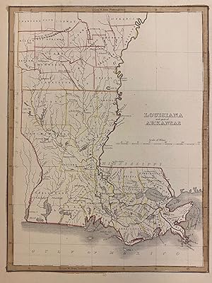
Louisiana and part of Arkansas
Verlag: W.D. Ticknor, Boston, 1835
Anbieter: Argosy Book Store, ABAA, ILAB, New York, NY, USA
Bewertung:
unbound. Map. Engraving with original hand outline. Image measures 7 3/4" x 10 1/4". Lovely map of Louisiana and Arkansas published in 1835. Hand colored to show early county divisions. Rivers, cities, and parishes are labeled. The Masserne Mountains, now known as the Ozarks, are depicted pictorially. Several Indian villages are noted - including Caddo, Coshatta, and Delaware. From "A Comprehensive Atlas Geographical, Historical and Commercial". Minor foxing to margins. T.G. Bradford (1802-1887) was a Boston based publisher. He worked as assistant editor of the American Encyclopedia before entering the field of map making.
-
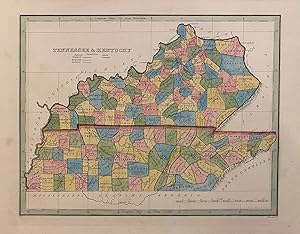
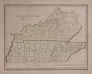
Tennessee & Kentucky
Verlag: Bradford, Thomas Gamaliel, Boston, 1835
Anbieter: Argosy Book Store, ABAA, ILAB, New York, NY, USA
Bewertung:
unbound. Boynton, G.W. (illustrator). Map. Engraving with hand-coloring. Image measures 7 7/8" x 10 1/8" Early map of Tennessee and Kentucky divided into counties. Shows towns, waterways, railroads and topographical details. Published after the passage of the Indian Removal Act 1830, but before Cherokee Removal in 1838, this map includes Cherokee Territory (and Brainerd mission) in the southeast corner. Minor spotting at margins, not affecting the image. T.G. Bradford (1802-1887) was a Boston based publisher. He worked as assistant editor of the American Encyclopedia before entering the field of map making.
-
Tennessee & Kentucky
Verlag: Bradford, Thomas Gamaliel, Boston, 1835
Anbieter: Argosy Book Store, ABAA, ILAB, New York, NY, USA
Bewertung:
unbound. Boynton, G.W. (illustrator). Map. Engraving with hand-colored outline. Image measures 7 7/8" x 10 1/8" Early map of Tennessee and Kentucky divided into counties. Shows towns, waterways, railroads and topographical details. Published after the passage of the Indian Removal Act 1830, but before Cherokee Removal in 1838, this map includes Cherokee Territory (and Brainerd mission) in the southeast corner. Minor wear expected with age, mostly to margins. Paperclip indentation, not affecting the image. T.G. Bradford (1802-1887) was a Boston based publisher. He worked as assistant editor of the American Encyclopedia before entering the field of map making.
-
A Comprehensive Atlas : Geographical, Historical and Commercial (Classic Reprint)
Verlag: Forgotten Books, 2018
ISBN 10: 1397243082ISBN 13: 9781397243089
Buch
Zustand: Sehr gut. Zustand: Sehr gut - Gepflegter, sauberer Zustand. | Seiten: 256.
-

Encyclopaedia Americana: A Popular Dictionary of Arts, Sciences, Literature, History, Politics and Biography, Brought Down to the Present Time
Verlag: ARKOSE PR, 2015
ISBN 10: 1345461410ISBN 13: 9781345461411
Buch
Gebunden. Zustand: New.
-

Encyclopćdia Americana: A Popular Dictionary of Arts, Sciences, Literature, History, Politics, and Biography, Brought Down to the Present Time; . On the Basis of the Seventh Edition
Verlag: Legare Street Press, 2022
ISBN 10: 1018394281ISBN 13: 9781018394282
Buch
Gebunden. Zustand: New.
-
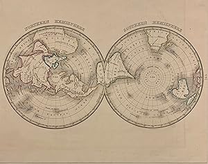
Northern Hemisphere / Southern Hemisphere
Verlag: Bradford, Thomas Gamaliel, Boston, 1835
Anbieter: Argosy Book Store, ABAA, ILAB, New York, NY, USA
Bewertung:
unbound. Map. Engraving with original hand outline coloring. Image measures 10" x 7.75". Unusual polar projection world map with wonderful joined design. Australia is still called New Holland. T.G. Bradford (1802-1887) was a Boston based publisher. He worked as assistant editor of the American Encyclopedia before entering the field of map making.
-

United States
Verlag: Ticknor, W.D., Boston, 1835
Anbieter: Argosy Book Store, ABAA, ILAB, New York, NY, USA
Bewertung:
unbound. Map. Engraving with original color outline. Image measures 7 3/45" x 9 7/8". Nice early map of the United States showing the states and territories. The southwest, Texas and California are part of Mexico. In good condition. One small closed tear at margin, not affecting the image. T.G. Bradford (1802-1887) was a Boston based publisher. He worked as assistant editor of the American Encyclopedia before entering the field of map making. He was best known for his 1835 "A Comprehensive Atlas: Geographical, Historical & Commercial" and his 1838 "Illustrated Atlas Geographical, Statistical and Historical of the United States and Adjacent Countries", both of which proved to be important contributions to American cartography.
-
New York
Verlag: T.G. Bradford, Boston, 1838
Anbieter: Argosy Book Store, ABAA, ILAB, New York, NY, USA
Bewertung:
unbound. G.W. Boynton (illustrator). Map. Engraving with original hand coloring. Image measures 14" x 11 1/4" Beautiful map of New York State, colored to show counties. Cities, towns, major routes, rivers, railroads, and canals are labeled. A dark and clear impression with delicate hand coloring. In very good condition, with minor wear to margins not affecting the image. Thomas Gamaliel Bradford (1802-1887) was a Boston based publisher. He worked as assistant editor of the American Encyclopedia before entering the field of map making. He was best known for his important contributions to American cartography, the 1838 "Illustrated Atlas Geographical, Statistical and Historical of the United States and Adjacent Countries.".
-
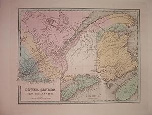
Lower Canada and New Brunswick
Verlag: Bradford, Thomas Gamaliel, Boston, 1838
Anbieter: Argosy Book Store, ABAA, ILAB, New York, NY, USA
Bewertung:
unbound. Zustand: very good. Boynton, G.W. (illustrator). Map. Engraving with original hand coloring. Image measures 11.25" x 14.25". Includes inset of Nova Scotia. T.G. Bradford (1802-1887) was a Boston based publisher. He worked as assistant editor of the American Encyclopedia before entering the field of map making.
-
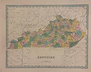
Kentucky
Verlag: Bradford, Thomas Gamaliel, Boston, 1838
Anbieter: Argosy Book Store, ABAA, ILAB, New York, NY, USA
Bewertung:
unbound. Boynton, G.W. (illustrator). Map. Engraving with hand-colored outline. Image measures 11 3/8" x 14 1/2" Early map of Kentucky divided into counties. Shows towns, waterways, railroads and topographical details. In very good condition. Minor wear to margins, not affecting the image. T.G. Bradford (1802-1887) was a Boston based publisher. He worked as assistant editor of the American Encyclopedia before entering the field of map making.
-
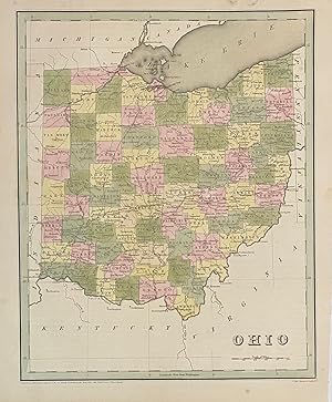
Ohio
Verlag: T.G. Bradford, Boston, 1838
Anbieter: Argosy Book Store, ABAA, ILAB, New York, NY, USA
Bewertung:
unbound. S. Stiles, Sherman and Smith (illustrator). Map. Engraving with original hand coloring. Image measures 14" x 11 1/4". Nice early map of Ohio divided into counties and townships showing major routes, railroads and geographical details. This is the first edition of this map. published in 1838. In very good condition. Minimal foxing to margin, not affecting the image. T.G. Bradford (1802-1887) was a Boston based publisher. He worked as assistant editor of the American Encyclopedia before entering the field of map making. He was best known for his 1835 "A Comprehensive Atlas: Geographical, Historical & Commercial" and his 1838 "Illustrated Atlas Geographical, Statistical and Historical of the United States and Adjacent Countries", both of which proved to be important contributions to American cartography.
-
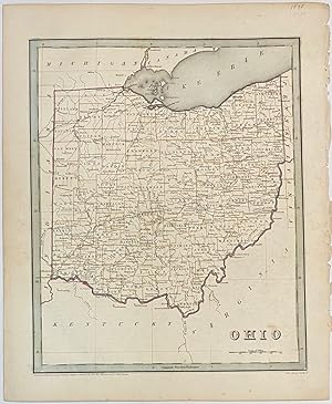
Ohio
Verlag: T.G. Bradford, Boston, 1838
Anbieter: Argosy Book Store, ABAA, ILAB, New York, NY, USA
Bewertung:
unbound. S. Stiles, Sherman and Smith (illustrator). Map. Engraving with original hand colored outline. Image measures 14" x 11 1/4". Nice early map of Ohio divided into counties and townships showing major routes, railroads and geographical details. This is the first edition of this map. published in 1838. Minor overall wear, pinholes to right edge, faint scattered foxing. T.G. Bradford (1802-1887) was a Boston based publisher. He worked as assistant editor of the American Encyclopedia before entering the field of map making. He was best known for his 1835 "A Comprehensive Atlas: Geographical, Historical & Commercial" and his 1838 "Illustrated Atlas Geographical, Statistical and Historical of the United States and Adjacent Countries", both of which proved to be important contributions to American cartography.
-
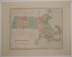
Massachusetts
Verlag: T.G. Bradford, Boston, 1838
Anbieter: Argosy Book Store, ABAA, ILAB, New York, NY, USA
Bewertung:
unbound. Zustand: very good(+). G.W. Boynton (illustrator). Map. Engraving with original hand coloring. Image measures 11 1/8" x 14 3/8". Nice early map of Massachusetts divided into counties and townships showing major routes, railroads and geographical details. Minor tape residue to top and bottom edges. Full original margins. T.G. Bradford (1802-1887) was a Boston based publisher. He worked as assistant editor of the American Encyclopedia before entering the field of map making.
-
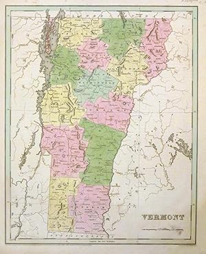
Vermont
Verlag: T.G. Bradford, Boston, 1838
Anbieter: Argosy Book Store, ABAA, ILAB, New York, NY, USA
Bewertung:
unbound. G.W. Boynton (illustrator). Map. Engraving with original hand coloring. Image measures 14.5 x 11". This map of Vermont is a portrait of the state in 1838 divided into counties. Cities are labeled and topography noted with elevation by hachure. The map identifies Killington Peak, a popular ski resort today. Maps exclusively depicting Vermont from this period are not common as the state was usually paired along with New Hampshire. The map appeared in the 1838 large-folio edition of Bradford's "Illustrated Atlas." The map is in good condition with minor stains neat the scale and the lower margin. Minor foxing. Thomas Gamaliel Bradford (1802-1887) was a Boston-based map publisher best known for his "important contributions to American cartography, the 1838 "Illustrated Atlas Geographical, Statistical and Historical of the United States and Adjacent Countries." Unlike many other atlases of the period, the volume included extensive text on the history, economics and geography of the areas mapped. His atlas represented an important contribution to American cartography, as this fine map clearly demonstrates.
-
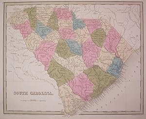
South Carolina
Verlag: Bradford, Thomas Gamaliel, Boston, 1838
Anbieter: Argosy Book Store, ABAA, ILAB, New York, NY, USA
Bewertung:
unbound. Zustand: very good. Boynton, G.W. (illustrator). Map. Engraving with original hand outline coloring. Image measures 11.5" x 14.25". Beautiful map of South Carolina divided into counties. Shows towns and waterways. In very good conditon with light foxing to outer margins and faint creasing. T.G. Bradford (1802-1887) was a Boston based publisher. He worked as assistant editor of the American Encyclopedia before entering the field of map making.
-
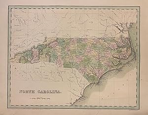
North Carolina
Verlag: Bradford, Thomas Gamaliel, Boston, 1839
Anbieter: Argosy Book Store, ABAA, ILAB, New York, NY, USA
Bewertung:
unbound. Map. Engraving with original hand coloring. Image measures 11 3/8" x 14 1/2" Beautiful early map of North Carolina divided into counties, showing towns, major routes, railroads and geographical details. The map is in good condition. Small closed tears at margins. T.G. Bradford (1802-1887) was a Boston based publisher. He worked as assistant editor of the American Encyclopedia before entering the field of map making. He was best known for his "important contributions to American cartography, the 1838 "Illustrated Atlas Geographical, Statistical and Historical of the United States and Adjacent Countries.".
-
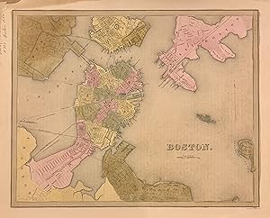
Boston
Verlag: T.G. Bradford, Boston, 1838
Anbieter: Argosy Book Store, ABAA, ILAB, New York, NY, USA
Bewertung:
unbound. G.W. Boynton (illustrator). Map. Engraving with original hand coloring. Image measures 11 3/8" x 14 1/8". Beautiful early map of Boston and parts of Cambridge, Brookline, Charlestown, East and South Boston. Showing wards, streets parks, railroads and notable landmarks. Light scattered foxing, stain and minor wear to upper right corner, with stains to margins and some offsetting. Thomas Gamaliel Bradford (1802-1887) was a Boston based publisher. He worked as assistant editor of the American Encyclopedia before entering the field of map making. He was best known for his important contributions to American cartography, the 1838 "Illustrated Atlas Geographical, Statistical and Historical of the United States and Adjacent Countries.".
-
West Indies
Verlag: T.G. Bradford, Boston, 1846
Anbieter: Argosy Book Store, ABAA, ILAB, New York, NY, USA
Bewertung:
unbound. Map. Engraving with original hand coloring. Image measures 11.25 x 14". This desirable 1846 map of the West Indies was issued by T. G. Bradford. It extends from southern Florida to the Gulf of Panama and the Spanish Main and includes the Bahamas, the Leeward and Windward Islands. An inset near top center details the Bermudas. Towns, rivers, mountains and various other important topographical details are noted. Copyrighted to 1838, the map is corrected to 1846. In good condition with minor foxing at places. Thomas Gamaliel Bradford (1802-1887) was a Boston-based map publisher best known for his "important contributions to American cartography, the 1838 "Illustrated Atlas Geographical, Statistical and Historical of the United States and Adjacent Countries." Unlike many other atlases of the period, the volume included extensive text on the history, economics and geography of the areas mapped. His atlas represented an important contribution to American cartography, as this fine map clearly demonstrates.