Gesamtpreis (1 Artikel Artikel):
Versandziel:

brué adrien hubert (30 Ergebnisse)
Direkt zu den wichtigsten Suchergebnissen
Produktart
- Alle Produktarten
- Bücher (29)
- Magazine & Zeitschriften
- Comics
- Noten
- Kunst, Grafik & Poster
- Fotografien
- Karten (1)
-
Manuskripte &
Papierantiquitäten
Zustand
Einband
Weitere Eigenschaften
- Erstausgabe (1)
- Signiert
- Schutzumschlag
- Angebotsfoto (29)
Land des Verkäufers
Verkäuferbewertung
-

Examen De L\ article Inséré Per M. Malte-brun Dans Le 19. Volume Des Nouvelles Annales Des Voyages Sur L\ atlas Universel De Géographie Et D\ histoire
Verlag: WENTWORTH PR, 2018
ISBN 10: 0274743574ISBN 13: 9780274743575
Buch
Zustand: New.
-
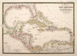
Carte des Isles Antilles des Etats Unis de L'Amérique Centrale et de la Mer du Mexique. Central America and the West Indies.
Verlag: Paris. c1840, 1840
Anbieter: Peter Harrington. ABA/ ILAB., London, Vereinigtes Königreich
Verbandsmitglied: ABA ILAB PBFA
Bewertung:

A detailed map of the Caribbean, Central America, and the Gulf of Mexico. Steel engraving. Original colour. Fine condition. Size: 52.7 x 37.6 cm.
-
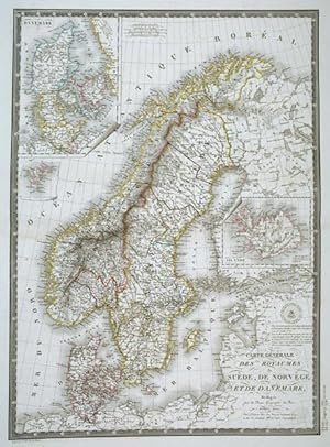
Carte Générale des Royaumes Sučde, De Norvčge et de Danemark.
Erscheinungsdatum: 1825
Anbieter: Altea Antique Maps, London, Vereinigtes Königreich
Verbandsmitglied: ABA ILAB PBFA
Bewertung:
Karte
Paris, 1825. Original colour. Steel-engraving, 550 x 400mm. Fine impression. Detailed map.Two insets, one of Denmark and one of Iceland.
-
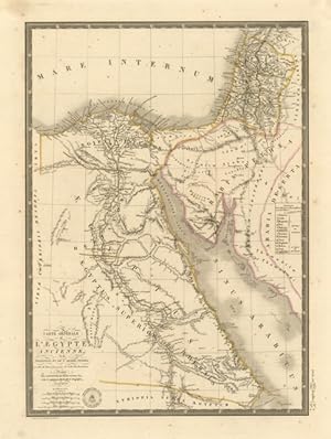
Carte PHYSIQUE, ADMINISTRATIVE ET ROUTIERE de la FRANCE, indiquant aussi la navigation intérieure du ROYAUME. [Maßstab: Ca. 1 : 950.000] . Mit 1 Nebenkt.: Corse. Nullmeridian: Paris.
Verlag: Goujon, Paris, 1818
Anbieter: Auceps-Antiquariat Sebastian Vogler, Weimar, Deutschland
Bewertung:
Hardcover. Zustand: Sehr gut. 1 Kt. auf 4 Einzelbl., Kupferst., Gesamtgr. 154 x 108 cm, je Bl. 77 x 54 cm, Mit Tabelle auf d. rechten Kartenrand. Maßstab in graph. Form (Mčtres ; toises ; Milles de 15 au Degré), farbige Grenzlinien. Auf Leinen aufgezogen, mehrfach gefaltet in grünem Schuber mit Rückentitel- u. altem Signaturenschildchen.
-
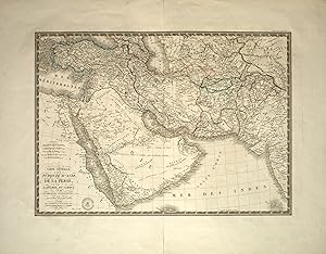
Carte Generale de la Turquie d'Asie, de la Perse, de l'Arabie, du Caboul et du Turkestan Independant.
Verlag: Paris, Adrien-Hubert Brué, 1826., 1826
Anbieter: Antiquariat INLIBRIS Gilhofer Nfg. GmbH, Vienna, A, Österreich
Verbandsmitglied: ILAB VDA VDAO
Bewertung:
Engraved map (680 x 535 mm), coloured in outline colour. This very detailed map gives an surprisingly precise overview of the regions surrounding Arabia and the cities located on Arabian Gulf. - Alai, General maps E.139 (note). Al-Qasimi 231.
-

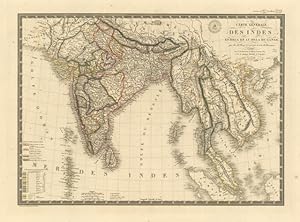
Atlas Universel de Geographie Physique, Politique et Historique, Ancienne et Moderne, contenant : Les Cartes Generales et particulieres des Cinq Parties du Monde" Dresse conformement aux progres de la Science Pour servir a la lecture des meilleurs ouv.
Erstausgabe
Paris, Chez L'Auteur, 1822. Imperial folio. (53,5 x 37,5 cm.). Contemp. (original) hcalf. Gilt spine with gilt lettering. Large orig. printed orange titlelabel on frontboard. Bookmark of CH. Picquet on inside frontboard (commissioned seller). Spine and edges rubbed. First inner hinge weak. Engraved title-page, engraved Table of content, (2) pp. and 35 (of 36) double-page folded engraved maps, all handcoloured in outline (except one map: Mappemonde Physique, which is uncoloured). The maps (dated 1820-25) are numbered 1-36, No. 18 lacks: "France, partie Occidentale". One extra map inserted "Carte generale de Colombie", dated 1826. All maps fine and clean, the map of Fance with 2 small closed tears, no loss. First edition of this atlas. It includes two maps of North America: , "Carte de l'Amerique Septentrionale", dated 1820 and "Carte General des Etats-Unis, du Canada et d'une Partie des Pays Adjacent." Dated 1825, and 2 world maps "Mappemonde Physique" and "Mappemonde en deux Hémisphéres" - Phillips Atlases 758 (later ed.).
-
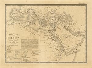
Monde connu des Hebreux
Verlag: Asia - Africa
Anbieter: Sergio Trippini, Gavirate, Italien
Bewertung:
-
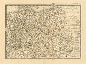
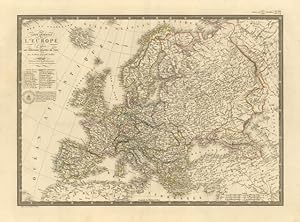
Carte Générale de l'Europe Centrale .
Verlag: Europa centrale
Anbieter: Sergio Trippini, Gavirate, Italien
Bewertung:
Restauro alla piega centrale editoriale.
-
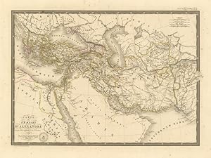
Carte de l'Empire d'Alexandre
Verlag: Impero di Alessandro Magno
Anbieter: Sergio Trippini, Gavirate, Italien
Bewertung:
-
Carte Générale de l'Egypte ancienne, .
Verlag: Egitto
Anbieter: Sergio Trippini, Gavirate, Italien
Bewertung:
-
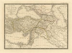
Carte Générale de l'Asie Mineure .
Verlag: Asia
Anbieter: Sergio Trippini, Gavirate, Italien
Bewertung:
-
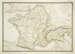
Carte Générale des Gaules
Verlag: Francia - Italia
Anbieter: Sergio Trippini, Gavirate, Italien
Bewertung:
-
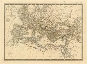
Carte Générale de l'Empire Romain sous Constantin
Verlag: Impero Romano
Anbieter: Sergio Trippini, Gavirate, Italien
Bewertung:
-
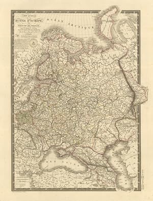
Carte Générale de la Russie d'Europe
Verlag: Russia
Anbieter: Sergio Trippini, Gavirate, Italien
Bewertung:
-
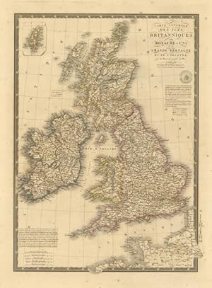
Carte Générale des Iles Britanniques .
Verlag: Gran Bretagna
Anbieter: Sergio Trippini, Gavirate, Italien
Bewertung:
-
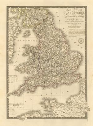
Carte Particuliere de l'Angleterre .
Verlag: Inghilterra
Anbieter: Sergio Trippini, Gavirate, Italien
Bewertung:
-
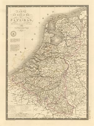
Carte du Royaume des Pays - Bas
Verlag: Paesi Bassi
Anbieter: Sergio Trippini, Gavirate, Italien
Bewertung:
-
Carte de la France en 1789 .
Verlag: Francia
Anbieter: Sergio Trippini, Gavirate, Italien
Bewertung:
-
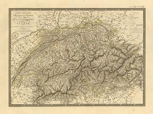
Carte Générale Phisique et Routiere des 22 Cantons de la Confederation Suisse
Verlag: Svizzera
Anbieter: Sergio Trippini, Gavirate, Italien
Bewertung:
-
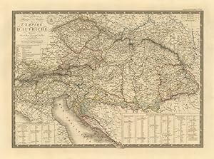
Carte Générale Physique et Routiere de l'Empire d'Autriche
Verlag: Impero Austriaco - Austria
Anbieter: Sergio Trippini, Gavirate, Italien
Bewertung:
-
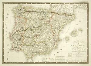
Carte Générale de l'Espagne et du Portugal
Verlag: Spagna (Espańa)
Anbieter: Sergio Trippini, Gavirate, Italien
Bewertung:
-
-
-
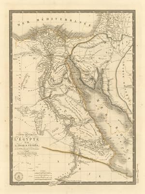
Carte Générale de l'Egypte et de l'Arabie Pétrée
Verlag: Egitto
Anbieter: Sergio Trippini, Gavirate, Italien
Bewertung:
-
Carte Générale de la Monarchie Prussienne
Verlag: Prussia
Anbieter: Sergio Trippini, Gavirate, Italien
Bewertung:
-
-
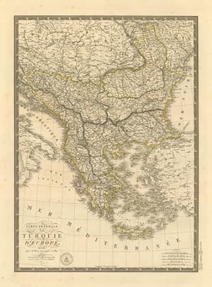
Carte Générale de la Turquie d'Europe
Verlag: Penisola Balcanica
Anbieter: Sergio Trippini, Gavirate, Italien
Bewertung:
-
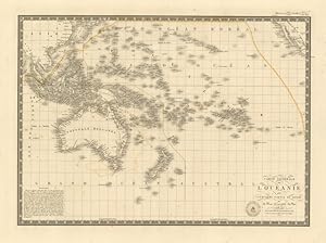
Carte Générale de l'Oceanie .
Verlag: Oceania
Anbieter: Sergio Trippini, Gavirate, Italien
Bewertung:
-
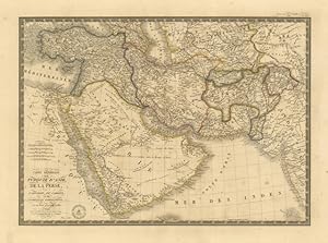
Carte Générale de la Turquie d'Asie, de la Perse .
Verlag: Asia - Arabia
Anbieter: Sergio Trippini, Gavirate, Italien
Bewertung:
-
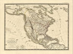
Carte Générale de l'Amerique Septentrionale .
Verlag: America Settentrionale e centrale
Anbieter: Sergio Trippini, Gavirate, Italien
Bewertung:
![Bild des Verkäufers für Carte PHYSIQUE, ADMINISTRATIVE ET ROUTIERE de la FRANCE, indiquant aussi la navigation intérieure du ROYAUME. [Maßstab: Ca. 1 : 950.000] . Mit 1 Nebenkt.: Corse. Nullmeridian: Paris. zum Verkauf von Auceps-Antiquariat Sebastian Vogler](https://pictures.abebooks.com/inventory/md/md31783731994.jpg)