Gesamtpreis (1 Artikel Artikel):
Versandziel:

carver jonathan (34 Ergebnisse)
Direkt zu den wichtigsten Suchergebnissen
Produktart
- Alle Produktarten
- Bücher (33)
- Magazine & Zeitschriften
- Comics
- Noten
- Kunst, Grafik & Poster
- Fotografien
- Karten (1)
-
Manuskripte &
Papierantiquitäten
Zustand
Einband
Weitere Eigenschaften
- Erstausgabe (4)
- Signiert
- Schutzumschlag
- Angebotsfoto (24)
Gratisversand
Land des Verkäufers
Verkäuferbewertung
-

Granta 21: The First Twenty-One Years
Verlag: Grove Press, Granta, 2001
ISBN 10: 186207464XISBN 13: 9781862074644
Anbieter: Wonder Book, Frederick, MD, USA
Bewertung:

Buch
Zustand: Good. Good condition. A copy that has been read but remains intact. May contain markings such as bookplates, stamps, limited notes and highlighting, or a few light stains. Bundled media such as CDs, DVDs, floppy disks or access codes may not be included.
Mehr Angebote von anderen Verkäufern bei ZVAB
Gebraucht ab EUR 5,78
-
Les Aventures de Carver chez les Sauvages de l'Amerique Septentrionale.
Erscheinungsdatum: 1870
Anbieter: Libreria Piani, Monte San Pietro, BO, Italien
Bewertung:
Buch
Tours, Mame et Fils, 1870. 8vo, cartonato editoriale decorato a due colori con ricchi fregi in oro e bella ill. litografata a colori al piatto ant. (piatti e cerniere con lievi mende marg.), pp.240. Frontespizio fig. inc. in acciaio, antip. inc. con veduta delle Cascate del Niagara. Parziali fioriture. Memorie del noto esploratore inglese.
-
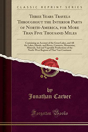
Three Years Travels Throughout the Interior Parts of North-America, for More Than Five Thousand Miles : Containing an Account of the Great Lakes, and All the Lakes, Islands, and Rivers, Cataracts, Mountains, Minerals, Soil and Vegetable Productions of the
Verlag: Forgotten Books, 2017
ISBN 10: 028261124XISBN 13: 9780282611248
Buch
Zustand: Wie neu. Zustand: Wie neu.
-

A Treatise on the Culture of the Tobacco Plant With the Manner in Which it is Usually Cured
Verlag: CHIZINE PUBN, 2018
ISBN 10: 1377335526ISBN 13: 9781377335520
Buch
Zustand: New.
-

Zustand: Wie neu. Zustand: Wie neu | Seiten: 72.
-
Zustand: Sehr gut. Zustand: Sehr gut - Gepflegter, sauberer Zustand. | Seiten: 578.
-

Three Years Travels Through the Interior Parts of North-America, for More Than Five Thousand Miles: . Together with a Concise History of the Genius,
Verlag: GALE ECCO SABIN AMERICANA, 2012
ISBN 10: 127563883XISBN 13: 9781275638839
Buch
Zustand: New.
-

Travels in Wisconsin. 3d London Ed
Verlag: CHIZINE PUBN, 2018
ISBN 10: 1378028708ISBN 13: 9781378028704
Buch
Zustand: New.
-

CARVERS TRAVELS IN WISCONSIN
Verlag: CHIZINE PUBN, 2018
ISBN 10: 1378680723ISBN 13: 9781378680728
Buch
Zustand: New.
-
Voyages Dans Les Parties Intérieures De L\ amérique Septentrionale Pendant Le Cours De La Derničre Guerre 1766-1768.
Verlag: WENTWORTH PR, 2019
ISBN 10: 1012501108ISBN 13: 9781012501105
Buch
Kartoniert / Broschiert. Zustand: New.
-
Travels through the interior parts of North-America, in the years 1766, 1767, and 1768. By J. Carver, . Illustrated with copper plates.
Verlag: Gale ECCO, Print Editions, 2010
ISBN 10: 1140931520ISBN 13: 9781140931522
Buch
Zustand: New. KlappentextThe 18th century was a wealth of knowledge, exploration and rapidly growing technology and expanding record-keeping made possible by advances in the printing press. In its determination to preserve the century of revolution, G.
-

Travels through the interior parts of North-America in the years 1766, 1767, and 1768.
Verlag: GALE ECCO SABIN AMERICANA, 2012
ISBN 10: 1275640133ISBN 13: 9781275640139
Buch
Zustand: New.
-
![Bild des Verkäufers für Three Travels Throughout the Interior Parts of North-America for More Then [sic] Five Thousand Miles [microform] zum Verkauf von moluna](https://pictures.abebooks.com/inventory/md/md31726673014.jpg)
Three Travels Throughout the Interior Parts of North-America for More Then [sic] Five Thousand Miles [microform]
Verlag: LIGHTNING SOURCE INC, 2021
ISBN 10: 1013364864ISBN 13: 9781013364860
Buch
Gebunden. Zustand: New.
-

Travels in Wisconsin. 3d London Ed
Verlag: LIGHTNING SOURCE INC, 2015
ISBN 10: 1341504190ISBN 13: 9781341504198
Buch
Gebunden. Zustand: New.
-

Voyage Dans Les Parties Intérieures De L\ amérique Septentrionale: Pendant Les Années 1766, 1767 & 1768
Verlag: WENTWORTH PR, 2019
ISBN 10: 0353677779ISBN 13: 9780353677777
Buch
Gebunden. Zustand: New.
-
Hardcover. Zustand: Fair. No Jacket. Cover and binding are worn but intact. A reading copy in fair condition. 1813 printing by Isaih Thomas. Fragile condition, heavily foxed, original calf. Secure packaging for safe delivery. 1.56.
-

Couverture souple. Zustand: bon. ROD0045359: 1826. In-18. Broché. Bon état, Couv. convenable, Dos satisfaisant, Quelques rousseurs. 212 pages pour le tome 1 avec gravure en frontispice. 159 pages pour le tome 2 avec corte pliée couleur. Voyage de Jonathan Carver dans l'Amérique Septentrionale. . . . Classification Dewey : 910.4-Voyages.
-

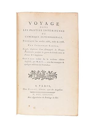
Voyage Dans Les Parties Interieures de L'Amerique Septentrionale Pendant les annees 1766, 1767 & 1768. Ecuyer, Capitaine d' une compagnie de troupes provinciales pendant la guerre du Canada entre la France & Angleterre. Ouvrage traduit fur la troisieme edition Anglosie, par M. De C. avec des remarques & quelques additions du traduleur
Verlag: Yverdon. [by Pissot, Paris]. 1784, 1784
Anbieter: J. Patrick McGahern Books Inc. (ABAC), Ottawa, ON, Kanada
Verbandsmitglied: ABAC ILAB IOBA
Bewertung:

8vo., (in 8's), , 16.5cm, First French Edition, from the 3rd London edition, xxxvi,436p., with half title, Wanting the folding map, title page vignette, wood cut head and tail pieces, in half tan calf, gilt ruled raised bands, black crushed morocco label, gilt titles marbled boards, fine copy attractively bound. (cgc). Howes C- 215. Carver a pâ nâ trâ plus loin dans l'Ouest que tout autre explorateur anglais avant la Râ volution. Comme son prâ dâ cesseur franâ ˇais - La Vâ rendrye - il cherchait une voie navigable transcontinentale, mais, . part l'exploration de certains affluents du Mississippi, il n'apporta aucune contribution substantielle . la connaissance gâ ographique ; son livre, cependant, a stimulâ la curiositâ concernant les routes vers le Pacifique, plus tard satisfaite par Mackenzie et Lewis et Clark. (Howes).
-
Voyage dans les parties interieures de l'Amerique Septentrionale pendant les annees 1766, 1767 & 1768. Ourage traduit sur la troisieme edition Angloise par M. de C. Avec des remarques & quelques addition du traducteur
Verlag: Firenze, 1784
Anbieter: Libreria Antiquaria Giulio Cesare di Daniele Corradi, Roma, ROMA, Italien
Bewertung:

p.perg coeva con tass. Tagli spruzzati, vari percorsi di tarlo estinto ai contropiatti XXXVI + 436 p. 177x115 mm.
-
Voyage Dans Les Parties Interieures de L?Amerique Septentrionale Pendant les annees 1766, 1767 & 1768.
Verlag: Pissot, Paris, 1784
Anbieter: Alexandre Antique Prints, Maps & Books, Toronto, ON, Kanada
Bewertung:

Erstausgabe
Zustand: Lacks the folding map. recent speckled calf with marbled boards, gilt spine with raised bands., The first French edition, taken from the third English edition, considered the best textually. Title page with printer?s device, wood cut head and tail pieces. The introduction bound out of order with a portion of it within the table of contents and another portion after page 450. Text in French., References : Howes C215.
-
Voyage dans les parties intérieures de l'Amérique Septentrionale, pendant les années 1766, 1767 & 1768
Erscheinungsdatum: 1784
Anbieter: Maggs Bros. Ltd ABA, ILAB, PBFA, BA, London, Vereinigtes Königreich
Verbandsmitglied: ABA ILAB PBFA
Bewertung:
Erstausgabe
First French edition. Folding map. 8vo. Contemporary mottled calf, gilt tooling to spine, leather label. Hinges cracking, with repairs to corners and spine ends. Discreet contemporary bookplate to front pastedown. Occasional spotting within. 24, xxviii, 451pp. Paris, Pissot, The first French edition, taken from the third English edition, considered the best textually. The French edition is enhanced by a very handsome printing of the Carver map, showing the area of the headwaters of the Mississippi, extending north well into Canada and west as far as the Dakotas. Carver went farther west than any explorer of the Northwest before the Revolution, and although he failed in his aim to find the mythical Northwest Passage, he added considerably to geographical knowledge. He also acted as a catalyst to the later explorations of Mackenzie and Lewis and Clark, and his narrative is in many ways a starting point in the literature of western exploration. Contains ?Des langues des Indiens, & des signes hiéroglyphiques qui leur tiennent lieu d'ecriture? on pages 315-334. The text contains the first mention of the word ?Oregon.? Bradford 801. Howes C215. Field 251. Pilling 641. Sabin 11188. Vail 670.
-
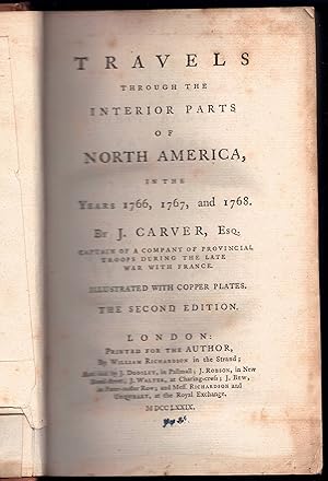
Travels through the interior parts of North America : in the years 1766, 1767, and 1768. 2. ed.
Verlag: London, Richardson et al., 1779
Anbieter: Wissenschaftliches Antiquariat Köln Dr. Sebastian Peters UG, Köln, Deutschland
Bewertung:
Zustand: gut. 12 Bl., 543 S., 2 Faltkarten, 5 Taf., 21,5 x 13,5 cm, Ledereinband der Zeit leicht berieben, Innendeckel mit Exlibris und handschr. Anmerkungen, gebräunt, teilweise leicht stockfleckig. Sprache: Englisch.
-
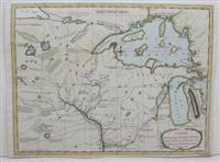
Carte des voyages du Cap.Carver, dans la partie interieure de L'Amerique Septentrionale, en 1766 et 1767.
Verlag: c. 1784, Paris, 1784
Anbieter: Alexandre Antique Prints, Maps & Books, Toronto, ON, Kanada
Bewertung:
Karte
An important map of the areas West of Lake Michigan and Lake Superior showing the area of the headwaters of the Mississippi, extending North well into Canada and West as far as the Dakotas. Carver went farther West than any explorer of the Northwest before the Revolution, and although he failed in his aim to find the mythical Northwest Passage, he added considerably to geographical knowledge of the area, Size : 280x352 (mm), 11x13.875 (Inches), Hand Colored, 0 Excellent; upper right margin extended.
-
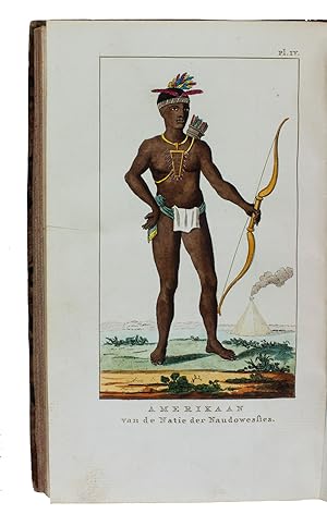
Reize door de binnenlanden van Noord-Amerika.Leiden, Abraham and Jan Honkoop, 1796. 2 parts in 1 volume. 8vo. With a small engraved author's portrait on title-page, a folding engraved map, and 5 (of 6) engraved plates (1 folding and 3 hand-coloured). Contemporary mottled half calf.
Anbieter: Antiquariaat FORUM BV, Houten, Niederlande
Bewertung:
Erstausgabe
[4], XXVI, [2], 248; [4], 280, [16] pp.First edition of the Dutch translation of a travelogue of North America by the English-American colonial captain Jonathan Carver (1710-1780). "In 1766 Carver was employed . to explore to the west of the Great Lake in an attempt to contact the Sioux Indians. . After wintering with the Indians on the Ste Croix River, Carver set out to return to Mackinac, but at the mouth of the Wisconsin met Captain James Tute, in command of a party send out to explore a route to the Pacific Ocean" (Howgego). The folding map shows the midlands of North America, the folding plate the St. Anthony waterfall in the Mississippi River and the hand-coloured engravings show different native American Indians.Lacking one of the engraved plates showing native Americans, otherwise in very good condition, only a few small spots. Binding slightly worn along the extremities, but still good.l Howgego, to 1800, C63; JCB II, 3776; Sabin 11190.
-
Voyage Dans Les Parties Interieures de L?Amerique Septentrionale Pendant les annees 1766, 1767 & 1768.
Verlag: Pissot c. 1784, Paris, 1784
Anbieter: Alexandre Antique Prints, Maps & Books, Toronto, ON, Kanada
Bewertung:
Erstausgabe
Full speckled calf, gilt spine with raised bands. , The first French edition, based on the third English edition, considered the best textually. Text in French. With the important map of the areas West of Lake Michigan and Lake Superior showing the area of the headwaters of the Mississippi, extending North well into Canada and West as far as the Dakotas. Carver went farther West than any explorer of the Northwest before the Revolution, and although he failed in his aim to find the mythical Northwest Passage, he added considerably to geographical knowledge of the area. , Size : 8vo, References : Howes C215., Title page with printer?s device, wood cut head and tail pieces. A fine example of this important work. Text and the map are clean and crisp. Map is beautifully hand colored.
-
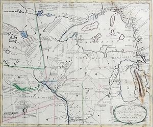
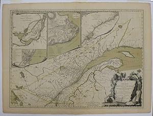
A Plan of Captain Carvers Travels in the interior Parts of North America
Verlag: J. Walter, London, 1778
Anbieter: Antipodean Books, Maps & Prints, ABAA, Garrison, NY, USA
Verbandsmitglied: ABAA ANZAAB ESA ILAB
Bewertung:
Zustand: Very good overall. A seldom-seen map by a British officer, one of the earliest to show "actual results of British exploration of the interior." (Wheat). It was issued with Carver's, "Travels through the Interior Parts of North-America, in the Years 1766, 1767, and 1768", considered one of the earliest and best accounts of the frontier in Minnesota and Wisconsin. "The delineation of the lower St. Peter (Minneosta) River was based on his (Carver's) visit to that region in 1766-67 as the first English-speaking explorer to push beyond the upper Mississipi River valley. The western interior, however, was copied from Bellin's map of 1755, which in turn was derived from the maps of La Verendrye. One innovation introduced by Carver is a dotted line connecting the Mandan River (the Great Bend of the Missouri River) with the imaginary "River of the West," which empties into the Pacific Ocean. This misconception led later American explorers to believe that the Pacific Ocean could be reached by a direct water route." III.i, p. 186-7, Luebke et al, "Mapping the North American Plains", Univ. of Oklahoma, 1987. The map is filled with details and notations such as "Traders go no farther than these falls" and "seldom travel this way except War Parties" and many more. The route of Carver's travels are clearly shown along the Mississippi, Fox, Minnesota and St. Pierre rivers. The map extends from Michigan, here labeled Chipeways and Ottowas Land, to above Lake Superior and west to beyond the Minnesota River. After the French and Indian War the peace settlement gave the British eastern Minnesota, opening the vast territory to their fur traders. Carver spent the winter of 1766-67 with the Sioux on the Minnesota River. He then joined Capt. James Tute's expedition as the mapmaker. Tute's plan was to cross the continent in quest of the Northwest Passage. The plan was not successful but their explorations led Carver to later publish an account of his travels. Carver is credited with traveling farther into the unknown West than any other English explorer before the Revolution. " (Old World Auctions). Image size 13.5x10.5", platemark 1/4" around the printed image plus wide margins on three sides, margin added on right side. Copper engraving, faint outline color. Neat restoration to a gap in the top margin. Old folds. OCLC: 312478177; Rumsey #5915.
-
A New Map of the Province Of Quebec, according According to the Royal Proclamation, of the 7th of October, 1763, from the French Surveys Connected with those Made after the War by Captain Carver, and others in His Majesty's Service
Verlag: Robert Sayer & John Bennett, London, 1776
Anbieter: Argosy Book Store, ABAA, ILAB, New York, NY, USA
Bewertung:
unbound. Map. Engraving with original color wash. Page measures This map shows the Province of Quebec as a newly acquired English territory according to the Treaty of Paris at the end of the French Indian War. Includes four lovely trompe l'oiel insets of the Isles of Montreal, Plan of Montreal, The City of Quebec, and the Course of the St. Lawrence. This British map extends the boundaries of Quebec into New England at a key point in the beginning of the Revolution. Captain Jonathan Carver (1732-1780) was a traveler, surveyor and cartographer who made this map based on his travels for Thomas Jeffery's American Atlas. Robert Sayer (1725-1794) was an important English publisher of maps, portraits, and nautical engravings. Partnering with John Bennett around the 1760s, the two published the works of well-known cartographers such as Kitchen, Jefferys, Belling, d'Anville and others. This is the first state of this scarce map.
-
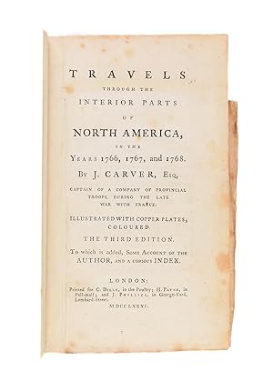
Travels Through the Interior Parts of North America, in the Years 1766, 1767, and 1768
Erscheinungsdatum: 1781
Anbieter: Maggs Bros. Ltd ABA, ILAB, PBFA, BA, London, Vereinigtes Königreich
Verbandsmitglied: ABA ILAB PBFA
Bewertung:
Third edition. Frontispiece portrait, five plates (four coloured), and two partially coloured folding maps. 8vo. Contemporary tree calf, gilt leather label, rebacked with original spine laid down, corners renewed, lacquered. Early 19th-century ownership signature on front free endpaper, light foxing. Very good. [4], 22, [22], 543, [1], [20]pp. London, A classic of American travel, in the third and best edition, with expanded text, a biographical sketch of the author, an index, and the added plate of the tobacco plant not found in the first two editions. Carver travelled farther west than any Englishman before the Revolution, going as far as the Dakotas, exploring the headwaters of the Mississippi and passing over the Great Lakes. The text contains the first published mention of the word ?Oregon.? The author comments on the Indigenous people he encountered, as well as offering observations on natural history. The tobacco plant plate is handsomely coloured. An important source book and stimulus for later explorers, especially Mackenzie and Lewis and Clark. This is the second issue, according to Howes, with the index. CHAR(13) + CHAR(10)Greenly Michigan, 21; Howes, C215 ?b?; Field, 251; Sabin, 11184; Vail, 670.
-
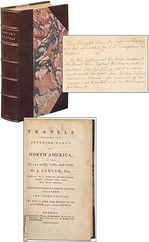
Travels Through the Interior Parts of North America, in the Years 1766, 1767, and 1768
Verlag: Printed for C. Dilly (et al), London, 1781
Anbieter: Between the Covers-Rare Books, Inc. ABAA, Gloucester City, NJ, USA
Verbandsmitglied: ABAA ESA ILAB IOBA
Bewertung:
Hardcover. Zustand: Fine. Third edition, second issue (with index). 543, [21]pp. Frontispiece of Carver. Five plates (four colored, including the tobacco plate that is frequently missing), two partially colored folding maps. Modern three-quarter morocco and marbled papercovered boards. A lovely, fine copy. Interesting early ink notation that the book was purchased from the library of Dr. John Jeffries (the first aeronaut to pass from England to France by balloon) when the library was sold at Boston by J.L. Cunningham. An important American travel narrative, this is considered the best edition with an expanded text, a biographical sketch of the author, an index, and the added plate of the tobacco plant. Text includes the first published mention of the word "Oregon." Howes C215; Sabin 11184.
-
Three Years Travels Through The Interior Parts Of North=America
Verlag: Philadelphia: Printed For Joseph Crukshank, 1792., 1792
Anbieter: D & E LAKE LTD. (ABAC/ILAB), Toronto, ON, Kanada
Bewertung:
Hardcover. 12mo. pp. xvi, vi, [1]blank, [9]-282. modern library cloth (some foxing, paper embrowned, library perforation stamp & other markings on 1st 2 leaves). Third or Fourth American Edition, after the first of 1784, of "a classic in the history of the exploration of the Great Lakes and upper Mississippi regions." "Carver s Travels was one of the most popular early books on the Middle West, and has appeared in thirty-two recorded editions and issues. The author was a native of Weymouth, Massachusetts, and with a commission from Major Robert Rogers set out on his travels in 1766." (Bell) "He went west by the route of the Great Lakes, crossed to the Mississippi by the Green-Bay-Fox-Wisconsin route, ascended the great river and entered the St. Peter s (now the Minnesota). He reached Lake Superior by the Chippewa and St. Croix rivers, and finally returned in the autumn of 1767 to Mackinac." (DAB) The work contains one of the earliest descriptions of what is now known as Minnesota and Wisconsin and the name 'Oregon' appears in print here for the first time. Evans 24181. Howes C-215. Sabin 11185. JCB II 2941n. cfLande 108. cfPilling, Algonquian, p. 68. cfBell C102. cfField 251. cfGraff 622. cfStreeter III 1772. cfTPL 415.