Gesamtpreis (1 Artikel Artikel):
Versandziel:

chodzko leonard dufour auguste henri (1 Ergebnisse)
Direkt zu den wichtigsten Suchergebnissen
Produktart
- Alle Produktarten
- Bücher (1)
- Magazine & Zeitschriften
- Comics
- Noten
- Kunst, Grafik & Poster
- Fotografien
- Karten
-
Manuskripte &
Papierantiquitäten
Zustand
- Alle
- Neu
- Antiquarisch/Gebraucht
Einband
- alle Einbände
- Hardcover
- Softcover
Weitere Eigenschaften
- Erstausgabe
- Signiert
- Schutzumschlag
- Angebotsfoto
Land des Verkäufers
Verkäuferbewertung
-
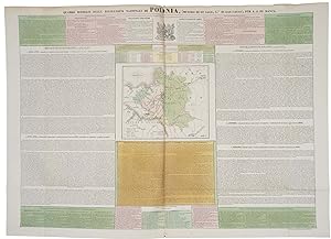
Atlante Istorico, Politico e Statistico della Polonia Antica e Moderna, con la indicazione dei suoi diversi smembramenti e divisioni.
Erscheinungsdatum: 1832
Anbieter: Altea Antique Maps, London, Vereinigtes Königreich
Verbandsmitglied: ABA ILAB PBFA
Bewertung:

Capolago (Switzerland): Tipografia Elvetica, 1832. Folio, original wrappers with title label and description; engr. title with colour key, folding map surrounded by letterpress, seven double-page maps, all with original hand colour, with descriptive labels pasted bottom right. A collection of maps illustrating the history of the dismemberment of Poland at the hands of Russia, Austria and Prussia. The seven double-page maps, each printed from the same plate, have been coloured differently and given a title label to show the various stages: Poland and its provinces, 1768; the First Dismemberment, 1772; the Second Dismemberment, 1793; the 'annihilation' of Poland as a kingdom, 1795; the creation of the Duchy of Warsaw by Napoleon, 1807; the Second Duchy of Warsaw, 1809 (with land won back from Austria after Wagram); and the New Kingdom of Poland, 1815 (as partitioned by the Congress of Vienna). The maps were prepared by Leonard Chodzko (1800-71), a Polish historian and political activist during the Polish November Uprising of 1830-1. When its failure started the Great Emigration he spent the rest of his life in France.