
Gesamtpreis (1 Artikel Artikel):
Versandziel:

colson nathaniel (3 Ergebnisse)
Direkt zu den wichtigsten Suchergebnissen
Produktart
- Alle Produktarten
- Bücher (3)
- Magazine & Zeitschriften
- Comics
- Noten
- Kunst, Grafik & Poster
- Fotografien
- Karten
-
Manuskripte &
Papierantiquitäten
Zustand
- Alle
- Neu
- Antiquarisch/Gebraucht
Einband
- alle Einbände
- Hardcover
- Softcover
Weitere Eigenschaften
- Erstausgabe
- Signiert
- Schutzumschlag
- Angebotsfoto
Land des Verkäufers
Verkäuferbewertung
-
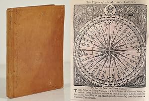
The mariner's new calendar. Containing the principles of arithmetic and practical geometry; with the extraction of the square and cube roots: also rules for finding the prime, epact, moon's age, time of high-water, with tables for the same. Together with exact tables of the sun's place, declination, and right-ascension: of the right ascension and declination of the principal fixed stars: of the latitude and longitude of places: a large table of difference of latitude and departure, for the exact working a traverse. Also the description and use of the sea-quadrant, fore-staff and nocturnal: necessary problems in plane-sailing and astronomy, wrought by the logarithms, and by Gunter's scale: a tide table: the courses and distances on the coast of Great Britain, Ireland, France, &c. And the soundings at coming into the Channel: with directions for sailing into some principal harbours. The whole revis'd, and adjusted to the new stile, by William Mountaine, F.R.S.
Erscheinungsdatum: 1768
Anbieter: Mats Rehnström Rare Books SVAF, ILAB, Stockholm, Schweden
Bewertung:

Zustand: Very Good. London, printed for J. Mount and T. Page, 1768. 4:o. 136 pp. With several small woodcut illustrations and larger woodcut illustrations on p. 20 and 63-64. Contemporary light brown calf, slightly worn, with sparingly blind-stamped covers. Blue sprinkled edges. Leather scraped off at head of spine, front joint starting at top, a few minor scratches. A nice copy with small bookplate of Anders Persson in Västerĺs on front pastedown.A large number of editions printed between 1676 and 1785 can be found in ESTC, although not this one. Verso of half title with a publisher's catalogue: "Books of navigation, sea charts, &c. printed for J. Mount and T. Page on Tower-hill". On pp. 89-136, with a new title leaf: "A large and useful table of difference of latitude and departure in minutes and thenths parts, to every degree and quarter point of the compass, for the exact working of a traverse". A popular guide for navigating at sea.
-
The Mariners New Kalender Containing the Principles of Arithmetick and Geometry Together with Exact Tables of the Sun's Place, Declination, and Right Ascension Also The Description and Use of the Sea-Quadrant, Fore-Staff and Nocturnal .A Large and very Useful Table of Difference of Latitude and Departure in Minutes and Tenth Parts, to every Degree and Quarter Point of the Compass for the Exact Working of the Traverse [2 parts in one volume]
Verlag: Printed for Thomas Page and William Mount, London, 1729
, 88, [1], 174-180, 97-132 pages, contains tables and illustrations and three two penny duty stamps to half title Early Edition , hinges repaired with new endpapers, corners, edges and joints rubbed, inked name to front board and rear endpaper, initials to last leaf (Rick Lewis 1731 Gloss), close trimming to pages with very slight loss of running title at top of p34, p97, p107-109, p132 and p179, light mark to top of some pages, occasional burn marks to pages, some cockling, small tears to top of pages 81-85, good condition , contemporary panelled calf, four raised bands and gilt title to spine , quarto, 19 cm x 15 cm Hardback ISBN:
-
The Mariner's New Calendar. Containing, The Principles of Arithmetic and Practical Geometry; with the Extraction of the Square and Cube Roots: Also Rules for finding the Prime, Epact, Moon's Age, Time of High-Water, with Tables for the fame. Together with, Exact Tables of the Sun's Place, Declination, and Right-Ascension; Of the Right Ascension and Declination of the Principal Fixed Stars: A large Table of Difference of Latitude and Departure, for the exact Working a Traverie. Also, The Description and Use of the Sea-Quadrant, Fore-Staff and Nocturnal: . [+ folded print: "Nairne and Blunt, Mathematical, Optical and Philosphical Instrument-makers, no 20 in Cornhill"].
Verlag: Printed for J. Mount and T. Page and W. Mount on Tower-Hill,, London,, 1778
Anbieter: Llibreria Antiquŕria Delstres, Canet de Mar, BCN, Spanien
Bewertung:

Curiosa edición original de este calendario-manual para comerciantes, con las explicaciones pertenecientes al uso de las tablas, las distancias y diferencias de latitudes, y el uso de los aparatos como el sextante o el cuadrante marino. Lleva ańadido pegada a la portada una hoja plegada de "Nairne and Blunt, Mathematical, Optical and Philosphical Instrument-makers, no 20 in Cornhill" donde se vendian toda clase de instrumentos tanto matematicos como opticos, camaras oscuras, cuadrantes astronomicos, globos terraqueos, diferentes tipos de cilindros y lentes, etc. 136 páginas. Ilustrado con grabados de figuras geometricas, tablas y dos grabados del uso de aparatos como un sextante o cuadrante marino, dentro de texto. En la portada "Stamp according to Act. of Parliament With Three Four-penny stamps" (tres sellos a pie de página, de color rojo. Encuadernación en pergamino, con el titulo, autor y ańo rotulado en el lomo. Buen estado de conservación. 19,5x15 cm.
![Bild des Verkäufers für The Mariners New Kalender Containing the Principles of Arithmetick and Geometry Together with Exact Tables of the Sun's Place, Declination, and Right Ascension Also The Description and Use of the Sea-Quadrant, Fore-Staff and Nocturnal .A Large and very Useful Table of Difference of Latitude and Departure in Minutes and Tenth Parts, to every Degree and Quarter Point of the Compass for the Exact Working of the Traverse [2 parts in one volume] zum Verkauf von Keoghs Books](https://pictures.abebooks.com/inventory/md/md30604661297.jpg)
![Bild des Verkäufers für The Mariner's New Calendar. Containing, The Principles of Arithmetic and Practical Geometry; with the Extraction of the Square and Cube Roots: Also Rules for finding the Prime, Epact, Moon's Age, Time of High-Water, with Tables for the fame. Together with, Exact Tables of the Sun's Place, Declination, and Right-Ascension; Of the Right Ascension and Declination of the Principal Fixed Stars: A large Table of Difference of Latitude and Departure, for the exact Working a Traverie. Also, The Description and Use of the Sea-Quadrant, Fore-Staff and Nocturnal: . [+ folded print: "Nairne and Blunt, Mathematical, Optical and Philosphical Instrument-makers, no 20 in Cornhill"]. zum Verkauf von Llibreria Antiquŕria Delstres](https://pictures.abebooks.com/inventory/md/md31328912511.jpg)