Gesamtpreis (1 Artikel Artikel):
Versandziel:

desilver charles (12 Ergebnisse)
Direkt zu den wichtigsten Suchergebnissen
Produktart
- Alle Produktarten
- Bücher (12)
- Magazine & Zeitschriften
- Comics
- Noten
- Kunst, Grafik & Poster
- Fotografien
- Karten
-
Manuskripte &
Papierantiquitäten
Zustand
- Alle
- Neu
- Antiquarisch/Gebraucht
Einband
- alle Einbände
- Hardcover
- Softcover
Weitere Eigenschaften
- Erstausgabe
- Signiert
- Schutzumschlag
- Angebotsfoto
Land des Verkäufers
Verkäuferbewertung
-
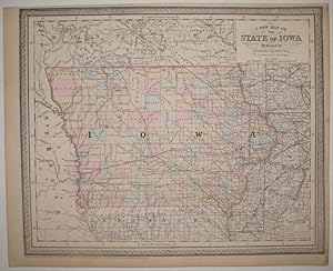
A New Map of the State of Iowa
Verlag: Desilver, Charles, Philadelphia, 1856
Anbieter: Argosy Book Store, ABAA, ILAB, New York, NY, USA
Bewertung:

unbound. Zustand: very good(+). Map. Engraving with original hand coloring. Image measures 13" x 16". Nice clear map of Iowa divided into counties. Showing towns, major routes, railroads and waterways. From the "New Universal Atlas". Plate was originally published by Samuel Augustus Mitchell, who sold the copyright to Thomas, Cowperthwait & Company in 1850, which was in turn bought by Charles Desilver in 1856. Top margin slightly cropped, light scattered staining.
-
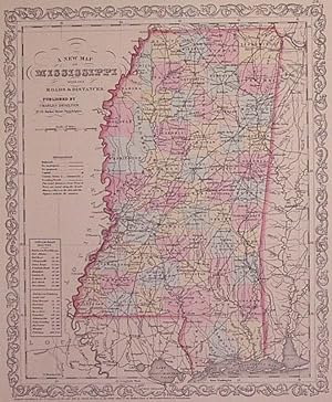
A New Map of Mississippi with its Roads & Distances
Verlag: Thomas, Cowperthwait & Co, Philadelphia, 1857
Anbieter: Argosy Book Store, ABAA, ILAB, New York, NY, USA
Bewertung:
unbound. Zustand: very good(+). Map. Engraving with original hand coloring. Image measures 14" x 11.5". Nice clean map of Mississippi divided into counties. Shows major cities, major routes, waterways and railroads. Includes table of steam boat routes. From the "New Universal Atlas". In excellent condition. Plate was originally published by Samuel Augustus Mitchell, who sold the copyright to Thomas, Cowperthwait & Company in 1850, which was in turn bought by Charles Desilver in 1856.
-
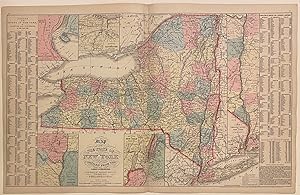
Map of the State of New York compiled from the latest authorities
Verlag: Desilver, Charles, Philadelphia, 1857
Anbieter: Argosy Book Store, ABAA, ILAB, New York, NY, USA
Bewertung:
unbound. Map. Engraving with original hand coloring. Image measures 16" x 26 1/8" Nice clear map of New York divided into counties. Shows towns, major routes, railroads, waterways, and topographical features. Insets include the vicinities of Albany, New York City, Rochester, and Niagara Falls, and a Map of the Hudson River from New York to Albany. On either side of the map is a table listing populations of counties and townships, square miles of counties, and other miscellaneous statistics. From the "New Universal Atlas". Plate was originally published by Samuel Augustus Mitchell, who sold the copyright to Thomas, Cowperthwait & Company in 1850, which was in turn bought by Charles Desilver in 1856. Charles Desilver (fl. 1856-1862) was a Philadelphia based map publisher active in the mid 19th century. He purchased the copyright for Mitchell's 'New Universal Atlas', publishing his own editions in 1856 and 1857. The maps from these editions were updated with the most recent information, especially related to roads, canals, and railways.
-
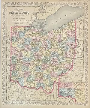
A New Map of the State of Ohio
Verlag: Desilver, Charles, Philadelphia, 1856
Anbieter: Argosy Book Store, ABAA, ILAB, New York, NY, USA
Bewertung:
unbound. Map. Engraving with original hand coloring. Image measures 16" x 13" Classic map of Ohio divided into counties. Showing towns, major routes, railroads and waterways. Includes an inset view showing the Vicinity of Cincinnati. In excellent condition. Charles Desilver (fl. 1856-1862) was a Philadelphia based map publisher active in the mid 19th century. He purchased the copyright for Mitchell's "New Universal Atlas", publishing his own editions in 1856 and 1857. The maps from these editions were updated with the most recent information, especially related to roads, canals, and railways.
-
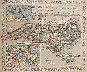
A New Map of the Nth. Carolina with its Canals, Roads & Distances from place to place, along the Stage and Steam Boat Routes
Verlag: Desilver, Charles, Philadelphia, 1857
Anbieter: Argosy Book Store, ABAA, ILAB, New York, NY, USA
Bewertung:
unbound. Map. Engraving with original hand coloring. Image measures 11 3/4" x 14" Nice clear map of North Carolina divided into counties. Shows towns, major routes, battle sites, railroads and waterways. Insets include the Gold Region and New Berne. Features a table of distances and the profile of the "Dismal Swamp Canal". From the "New Universal Atlas". Plate was originally published by Samuel Augustus Mitchell, who sold the copyright to Thomas, Cowperthwait & Company in 1850, which was in turn bought by Charles Desilver in 1856. Some scattered foxing. Full original margins.
-
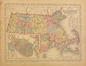
Map of Massachusetts and Rhode Island
Verlag: Desilver, Charles, Philadelphia, 1856
Anbieter: Argosy Book Store, ABAA, ILAB, New York, NY, USA
Bewertung:
unbound. Map. Engraving with original hand coloring. Image measures 11 3/4" x 15 1/4" Classic map of Massachusetts and Rhode Island divided into counties. Shows towns, major routes, railroads, waterways, and topographical features. An inset in the lower left features a plan of Boston, with streets, bridges, railroads, and major landmarks labeled. A statistical table in the upper right lists populations by county. In very good condition, with some toning to the left margin, and minor chips and tears to edges, not affecting the image. From the "New Universal Atlas". The plate was originally published by Samuel Augustus Mitchell, who sold the copyright to Thomas, Cowperthwait & Company in 1850, which was in turn bought by Charles Desilver in 1856. Charles Desilver (fl. 1856-1862) was a Philadelphia based map publisher active in the mid 19th century. He purchased the copyright for Mitchell's 'New Universal Atlas', publishing his own editions in 1856 and 1857. The maps from these editions were updated with the most recent information, especially related to roads, canals, and railways.
-
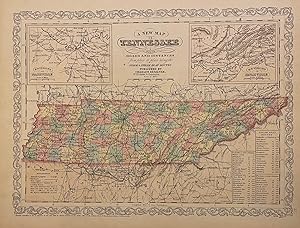
A New Map of Tennessee with its Roads & Distances
Verlag: Thomas, Cowperthwait & Co, Philadelphia, 1857
Anbieter: Argosy Book Store, ABAA, ILAB, New York, NY, USA
Bewertung:
unbound. Map. Engraving with original hand coloring. Image measures 14" x 11.5". Nice clean map of Tennessee divided into counties. Shows major cities, major routes, waterways and railroads. Includes table of steam boat routes. Includes two insets showing "Environs of Nashville" and "Environs of Knoxville". From the "New Universal Atlas". In excellent condition. Plate was originally published by Samuel Augustus Mitchell, who sold the copyright to Thomas, Cowperthwait & Company in 1850, which was in turn bought by Charles Desilver in 1856.
-
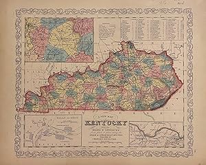
A New Map of Kentucky with its Roads & Distances
Verlag: Charles Desilver, Philadelphia, 1856
Anbieter: Argosy Book Store, ABAA, ILAB, New York, NY, USA
Bewertung:
unbound. Map. Engraving with original hand coloring. Image measures 14" x 11.5". Nice clean map of Kentucky divided into counties. Shows major cities, major routes, waterways and railroads. Includes table of steam boat routes. Includes insets showing larger scale depictions of roads surrounding Lexington, and along the Ohio River near Clarksburg, and at the Falls of Ohio near Louisville. A table in the upper right corner indicates steam boat routes from Louisville to Pittsburgh, and from Louisville to New Orleans. From the "New Universal Atlas". In very good condition with minor wear to margins, not affecting the image. Plate was originally published by Samuel Augustus Mitchell, who sold the copyright to Thomas, Cowperthwait & Company in 1850, which was in turn bought by Charles Desilver in 1856.
-
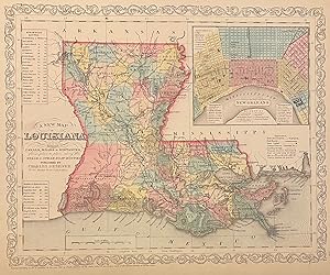
A New Map of Louisiana with its Canals, Roads, & Distances
Verlag: Charles Desilver, Philadelphia, 1856
Anbieter: Argosy Book Store, ABAA, ILAB, New York, NY, USA
Bewertung:
unbound. Map. Engraving with original hand coloring. Image measures 14 3/4" x 11 3/4" Lovely map of Louisiana divided into counties. Shows major cities, major routes, waterways and railroads. Includes inset showing New Orleans. A table in the upper left indicates steam boat routes from New Orleans to Pittsburgh, to Natchitoches, and to Balize. This map was published in Desilver's 1856 edition of the "New Universal Atlas". In excellent condition. Charles Desilver (fl. 1856-1862) was a Philadelphia based map publisher active in the mid 19th century. He purchased the copyright for Mitchell%u2019s %u201CNew Universal Atlas%u201D, publishing his own editions in 1856 and 1857. The maps from these editions were updated with the most recent information, especially related to roads, canals, and railways.
-
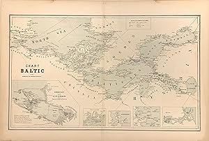
Chart of the Baltic from Admiralty & Russian Surveys
Verlag: William Boell, New York, 1857
Anbieter: Argosy Book Store, ABAA, ILAB, New York, NY, USA
Bewertung:
unbound. Map. Color lithograph. Image measures 11.75" x 14.25". This scarce chart of the Baltic Sea is exceptional for its precise rendering of the coastlines between Scandinavia and the coast of Western Europe. The waters of the central Baltic Sea extend outward into the Gulfs of Bothnia and Finland in the west and the North Sea in the East. Along the coasts, towns, forts, and lighthouses are labeled and establish a level of detail that carries over into the five insets along the bottom of the map. The largest, showing Coronstadt and St. Petersburg, includes multiple useful tips for navigators that identify dangerous conditions. The other four Sveaborg, Port Baltic, Reval, and Riga highlight some of the bustling ports in this significant region of European waterways. The map is in very good condition with full margins as issued. Light staining around edges not affecting the image. Map is bright and clean except for some slight discoloration along the center fold. It first appeared in Charles Desilver's edition of S.A. Mitchell's "New Universal Atlas" as published in 1856. This edition was published in New York by Boell.
-
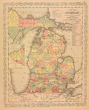
A New Map of Michigan with its Canals, Roads, & Distances
Verlag: Charles Desilver, Philadelphia, 1857
Anbieter: Argosy Book Store, ABAA, ILAB, New York, NY, USA
Bewertung:
unbound. Map. Engraving with original hand coloring. Image measures 14 3/4" x 11 3/4" Lovely map of Michigan divided into counties. Shows major cities, major routes, waterways and railroads. Includes inset showing the western part of upper Michigan. A table in the upper right corner indicates steam boat routes from Detroit to Fort Gratiot, and from Detroit to Fort Howard. This map was published in the 1857 edition of the "New Universal Atlas". In excellent condition. Plate was originally published by Samuel Augustus Mitchell, who sold the copyright to Thomas, Cowperthwait & Company in 1850, which was in turn bought by Charles Desilver in 1856. Roads and Distances are by J.H. Young.
-
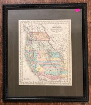
A New Map of the State of California, the Territories of Oregon, Washington, Utah & New Mexico
Verlag: Charles Desilver, Philadelphia, 1856
Anbieter: Ken Sanders Rare Books, ABAA, Salt Lake City, UT, USA
Verbandsmitglied: ABAA ILAB IOBA RMABA
Bewertung:

Map. Zustand: Fine. 13 1/2" x 16 1/2" [21 1/2" x 24 1/2" in mat and frame]. From "A New Universal Atlas," Philadelphia, C. Desilver, 1856, p. 37. Wheat Transmississippi West 890. Moffat 42. Colored by counties. Depicts roads, explorers' routes, and suggested railroad routes. The Gadsden Purchase is marked "Proposed Arizona Territory." A brightly colored map produced for Augustus S. Mitchell's atlas, and a map which claims to have been very updated. Desilver's map was well suited for school geography. It was issued shortly after the Gadsden Treaty of 1854, therefore the current southern border with Mexico is depicted. A great number of Indian tribes are shown. Great Indian Treaty Ground is marked. The counties are shown in vivid color, with several counties stretching across Utah and New Mexico. Updates to the map include the addition of new trails, including Fremont's and Kearney's routes.