
Gesamtpreis (1 Artikel Artikel):
Versandziel:

duncan william james (49 Ergebnisse)
Direkt zu den wichtigsten Suchergebnissen
Produktart
- Alle Produktarten
- Bücher (12)
- Magazine & Zeitschriften (1)
- Comics
- Noten
- Kunst, Grafik & Poster
- Fotografien
- Karten (35)
-
Manuskripte &
Papierantiquitäten (1)
Zustand
Einband
Weitere Eigenschaften
- Erstausgabe (4)
- Signiert (1)
- Schutzumschlag
- Angebotsfoto
Land des Verkäufers
Verkäuferbewertung
-

Our Home And Foreign Trade: A Supplement To notes On The Rates Of Discount In London, 1866-73, With Continuation To The Close Of 1876.
Verlag: LIGHTNING SOURCE INC, 2015
ISBN 10: 1342458710ISBN 13: 9781342458711
Buch
Gebunden. Zustand: New.
-
![Bild des Verkäufers für Notices and Documents Illustrative of the Literary History of Glasgow, During the Greater Part of Last Century [Ed. by W.J. Duncan] zum Verkauf von moluna](https://pictures.abebooks.com/inventory/md/md31546932337.jpg)
Notices and Documents Illustrative of the Literary History of Glasgow, During the Greater Part of Last Century [Ed. by W.J. Duncan]
Verlag: LIGHTNING SOURCE INC, 2016
ISBN 10: 1358703019ISBN 13: 9781358703010
Buch
Gebunden. Zustand: New.
-

Zustand: New.
-

Zustand: New.
-

The Naturalist\ s Library, Volume 7
Verlag: LIGHTNING SOURCE INC, 2016
ISBN 10: 1358825289ISBN 13: 9781358825286
Buch
Gebunden. Zustand: New.
-

The Naturalist\ s Library: Entomology, Volume 9
Verlag: LIGHTNING SOURCE INC, 2016
ISBN 10: 1358637598ISBN 13: 9781358637599
Buch
Gebunden. Zustand: New. KlappentextThis work has been selected by scholars as being culturally important, and is part of the knowledge base of civilization as we know it. This work was reproduced from the original artifact, and remains as true to the original w.
-
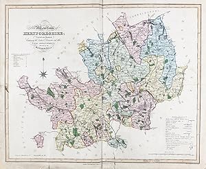
New Map of the County of Hertfordshire Divided into Hundreds Containing the District Divisions and other Local Arrangements effected by the Reform Bill" - Hertfordshire England Hertford
Verlag: London, 1833
Anbieter: Antiquariat Steffen Völkel GmbH, Seubersdorf, Deutschland
Bewertung:

Karte
Antique map in original color from 1833. Size: c. 47 x 39 cm. -- with some signs of wear, creases and fold marks, with deposited tears, otherwise in good condition. || Original handkolorierte Stahlstich-Karte von 1833. -- mit stärkeren Gebrauchsspuren, Knickspuren und hinterlegten Einrissen, sonst gut erhalten. || James Ebden's remarkable county maps are typical of the best maps produced for English atlases at the beginning of the 19th century. Skillfully engraved and beautifully hand colored, they are relatively large compared to the majority of other county maps of the early 19th century. Their size allows for a clearer, more detailed depiction of the regions. The maps show the individual counties and all their major roads. They are accompanied by a legend, further explanations of the symbols used, a mileage scale, and a description of the counties' districts and/or other territorial divisions. || Dies ist ein Original! - Kein Nachdruck! - Keine Kopie! -- This is an original! - No copy! - No reprint! Sprache: Englisch Gewicht in Gramm: 1550.
-
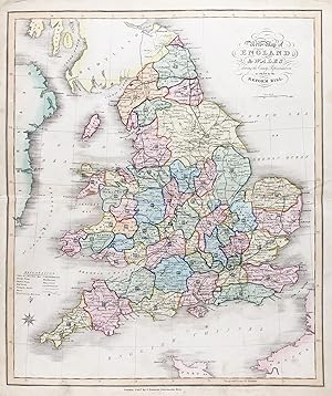
New Map of England & Wales showing the County Representation as effected by the Reform Bill" - England Wales Great Britain UK United Kingdom
Verlag: London, 1833
Anbieter: Antiquariat Steffen Völkel GmbH, Seubersdorf, Deutschland
Bewertung:
Karte
Antique map in original color from 1833. Size: c. 39 x 47 cm. -- with minor signs of wear, otherwise in very good condition. || Original handkolorierte Stahlstich-Karte von 1833. -- mit leichten Gebrauchspuren, sonst gut erhalten. || James Ebden's remarkable county maps are typical of the best maps produced for English atlases at the beginning of the 19th century. Skillfully engraved and beautifully hand colored, they are relatively large compared to the majority of other county maps of the early 19th century. Their size allows for a clearer, more detailed depiction of the regions. The maps show the individual counties and all their major roads. They are accompanied by a legend, further explanations of the symbols used, a mileage scale, and a description of the counties' districts and/or other territorial divisions. || Dies ist ein Original! - Kein Nachdruck! - Keine Kopie! -- This is an original! - No copy! - No reprint! Antique map in original color from 1833. Size: c. 47 x 39 cm. -- in very good condition. || Original handkolorierte Stahlstich-Karte von 1833. -- gut erhalten. || James Ebden's remarkable county maps are typical of the best maps produced for English atlases at the beginning of the 19th century. Skillfully engraved and beautifully hand colored, they are relatively large compared to the majority of other county maps of the early 19th century. Their size allows for a clearer, more detailed depiction of the regions. The maps show the individual counties and all their major roads. They are accompanied by a legend, further explanations of the symbols used, a mileage scale, and a description of the counties' districts and/or other territorial divisions. || Dies ist ein Original! - Kein Nachdruck! - Keine Kopie! -- This is an original! - No copy! - No reprint! Sprache: Englisch.
-
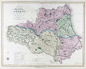
New Map of the County of Durnham; Divided into Wards; Containing the District Divisions and other Local Arrangements effected by the Reform Bill with the several railways" - Durham Auckland Sunderland Hartlepool
Verlag: London, 1833
Anbieter: Antiquariat Steffen Völkel GmbH, Seubersdorf, Deutschland
Bewertung:
Karte
Antique map in original color from 1833. Size: c. 39 x 47 cm. -- in very good condition. || Original handkolorierte Stahlstich-Karte von 1833. -- gut erhalten. || James Ebden's remarkable county maps are typical of the best maps produced for English atlases at the beginning of the 19th century. Skillfully engraved and beautifully hand colored, they are relatively large compared to the majority of other county maps of the early 19th century. Their size allows for a clearer, more detailed depiction of the regions. The maps show the individual counties and all their major roads. They are accompanied by a legend, further explanations of the symbols used, a mileage scale, and a description of the counties' districts and/or other territorial divisions. || Dies ist ein Original! - Kein Nachdruck! - Keine Kopie! -- This is an original! - No copy! - No reprint! Antique map in original color from 1833. Size: c. 47 x 39 cm. -- in very good condition. || Original handkolorierte Stahlstich-Karte von 1833. -- gut erhalten. || James Ebden's remarkable county maps are typical of the best maps produced for English atlases at the beginning of the 19th century. Skillfully engraved and beautifully hand colored, they are relatively large compared to the majority of other county maps of the early 19th century. Their size allows for a clearer, more detailed depiction of the regions. The maps show the individual counties and all their major roads. They are accompanied by a legend, further explanations of the symbols used, a mileage scale, and a description of the counties' districts and/or other territorial divisions. || Dies ist ein Original! - Kein Nachdruck! - Keine Kopie! -- This is an original! - No copy! - No reprint! Sprache: Englisch.
-
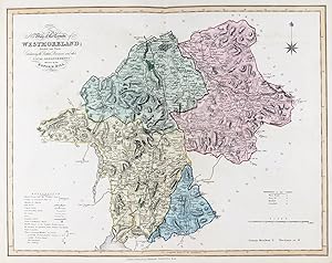
New Map of the County of Westmoreland; Divided into Wards; Containing the District Divisions and other Local Arrangements effected by the Reform Bill" - Westmorland Ambleside Kendal Windermere
Verlag: London, 1833
Anbieter: Antiquariat Steffen Völkel GmbH, Seubersdorf, Deutschland
Bewertung:
Karte
Antique map in original color from 1833. Size: c. 47 x 39 cm. -- in very good condition. || Original handkolorierte Stahlstich-Karte von 1833. -- gut erhalten. || James Ebden's remarkable county maps are typical of the best maps produced for English atlases at the beginning of the 19th century. Skillfully engraved and beautifully hand colored, they are relatively large compared to the majority of other county maps of the early 19th century. Their size allows for a clearer, more detailed depiction of the regions. The maps show the individual counties and all their major roads. They are accompanied by a legend, further explanations of the symbols used, a mileage scale, and a description of the counties' districts and/or other territorial divisions. || Dies ist ein Original! - Kein Nachdruck! - Keine Kopie! -- This is an original! - No copy! - No reprint! Antique map in original color from 1833. Size: c. 47 x 39 cm. -- in very good condition. || Original handkolorierte Stahlstich-Karte von 1833. -- gut erhalten. || James Ebden's remarkable county maps are typical of the best maps produced for English atlases at the beginning of the 19th century. Skillfully engraved and beautifully hand colored, they are relatively large compared to the majority of other county maps of the early 19th century. Their size allows for a clearer, more detailed depiction of the regions. The maps show the individual counties and all their major roads. They are accompanied by a legend, further explanations of the symbols used, a mileage scale, and a description of the counties' districts and/or other territorial divisions. || Dies ist ein Original! - Kein Nachdruck! - Keine Kopie! -- This is an original! - No copy! - No reprint! Sprache: Englisch.
-
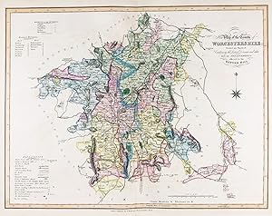
New Map of the County of Worcestershire; Divided into Hundreds; Containing the District Divisions and other Local Arrangements effected by the Reform Bill" - Worcestershire Worcester Droitwich Spa Bromsgrove
Verlag: London, 1833
Anbieter: Antiquariat Steffen Völkel GmbH, Seubersdorf, Deutschland
Bewertung:
Karte
Antique map in original color from 1833. Size: c. 39 x 47 cm. -- in very good condition. || Original handkolorierte Stahlstich-Karte von 1833. -- gut erhalten. || James Ebden's remarkable county maps are typical of the best maps produced for English atlases at the beginning of the 19th century. Skillfully engraved and beautifully hand colored, they are relatively large compared to the majority of other county maps of the early 19th century. Their size allows for a clearer, more detailed depiction of the regions. The maps show the individual counties and all their major roads. They are accompanied by a legend, further explanations of the symbols used, a mileage scale, and a description of the counties' districts and/or other territorial divisions. || Dies ist ein Original! - Kein Nachdruck! - Keine Kopie! -- This is an original! - No copy! - No reprint! Antique map in original color from 1833. Size: c. 47 x 39 cm. -- in very good condition. || Original handkolorierte Stahlstich-Karte von 1833. -- gut erhalten. || James Ebden's remarkable county maps are typical of the best maps produced for English atlases at the beginning of the 19th century. Skillfully engraved and beautifully hand colored, they are relatively large compared to the majority of other county maps of the early 19th century. Their size allows for a clearer, more detailed depiction of the regions. The maps show the individual counties and all their major roads. They are accompanied by a legend, further explanations of the symbols used, a mileage scale, and a description of the counties' districts and/or other territorial divisions. || Dies ist ein Original! - Kein Nachdruck! - Keine Kopie! -- This is an original! - No copy! - No reprint! Sprache: Englisch.
-
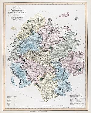
New Map of the County of Herefordshire; Divided into Hundreds; Containing the District Divisions and other Local Arrangements effected by the Reform Bill" - Herefordshire Hereford Leominster Ledbury Ross-on-Wye Kington
Verlag: London, 1833
Anbieter: Antiquariat Steffen Völkel GmbH, Seubersdorf, Deutschland
Bewertung:
Karte
Antique map in original color from 1833. Size: c. 47 x 39 cm. -- in very good condition. || Original handkolorierte Stahlstich-Karte von 1833. -- gut erhalten. || James Ebden's remarkable county maps are typical of the best maps produced for English atlases at the beginning of the 19th century. Skillfully engraved and beautifully hand colored, they are relatively large compared to the majority of other county maps of the early 19th century. Their size allows for a clearer, more detailed depiction of the regions. The maps show the individual counties and all their major roads. They are accompanied by a legend, further explanations of the symbols used, a mileage scale, and a description of the counties' districts and/or other territorial divisions. || Dies ist ein Original! - Kein Nachdruck! - Keine Kopie! -- This is an original! - No copy! - No reprint! Antique map in original color from 1833. Size: c. 47 x 39 cm. -- in very good condition. || Original handkolorierte Stahlstich-Karte von 1833. -- gut erhalten. || James Ebden's remarkable county maps are typical of the best maps produced for English atlases at the beginning of the 19th century. Skillfully engraved and beautifully hand colored, they are relatively large compared to the majority of other county maps of the early 19th century. Their size allows for a clearer, more detailed depiction of the regions. The maps show the individual counties and all their major roads. They are accompanied by a legend, further explanations of the symbols used, a mileage scale, and a description of the counties' districts and/or other territorial divisions. || Dies ist ein Original! - Kein Nachdruck! - Keine Kopie! -- This is an original! - No copy! - No reprint! Sprache: Englisch.
-
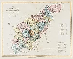
New Map of the County of Northamptonshire; Divided into Hundreds; Containing the District Divisions and other Local Arrangements effected by the Reform Bill" - Northamptonshire Northampton Thrapson Daventry Kettering Corby Oundle
Verlag: London, 1833
Anbieter: Antiquariat Steffen Völkel GmbH, Seubersdorf, Deutschland
Bewertung:
Karte
Antique map in original color from 1833. Size: c. 47 x 39 cm. -- in very good condition. || Original handkolorierte Stahlstich-Karte von 1833. -- gut erhalten. || James Ebden's remarkable county maps are typical of the best maps produced for English atlases at the beginning of the 19th century. Skillfully engraved and beautifully hand colored, they are relatively large compared to the majority of other county maps of the early 19th century. Their size allows for a clearer, more detailed depiction of the regions. The maps show the individual counties and all their major roads. They are accompanied by a legend, further explanations of the symbols used, a mileage scale, and a description of the counties' districts and/or other territorial divisions. || Dies ist ein Original! - Kein Nachdruck! - Keine Kopie! -- This is an original! - No copy! - No reprint! Antique map in original color from 1833. Size: c. 47 x 39 cm. -- in very good condition. || Original handkolorierte Stahlstich-Karte von 1833. -- gut erhalten. || James Ebden's remarkable county maps are typical of the best maps produced for English atlases at the beginning of the 19th century. Skillfully engraved and beautifully hand colored, they are relatively large compared to the majority of other county maps of the early 19th century. Their size allows for a clearer, more detailed depiction of the regions. The maps show the individual counties and all their major roads. They are accompanied by a legend, further explanations of the symbols used, a mileage scale, and a description of the counties' districts and/or other territorial divisions. || Dies ist ein Original! - Kein Nachdruck! - Keine Kopie! -- This is an original! - No copy! - No reprint! Sprache: Englisch.
-
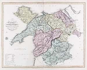
New Map of North Wales; Containing the District Divisions and other Local Arrangements effected by the Reform Bill" - North Wales Holyhead Bangor Anglesey Caernarfon
Verlag: London, 1833
Anbieter: Antiquariat Steffen Völkel GmbH, Seubersdorf, Deutschland
Bewertung:
Karte
Antique map in original color from 1833. Size: c. 47 x 39 cm. -- in very good condition. || Original handkolorierte Stahlstich-Karte von 1833. -- gut erhalten. || James Ebden's remarkable county maps are typical of the best maps produced for English atlases at the beginning of the 19th century. Skillfully engraved and beautifully hand colored, they are relatively large compared to the majority of other county maps of the early 19th century. Their size allows for a clearer, more detailed depiction of the regions. The maps show the individual counties and all their major roads. They are accompanied by a legend, further explanations of the symbols used, a mileage scale, and a description of the counties' districts and/or other territorial divisions. || Dies ist ein Original! - Kein Nachdruck! - Keine Kopie! -- This is an original! - No copy! - No reprint! Antique map in original color from 1833. Size: c. 47 x 39 cm. -- in very good condition. || Original handkolorierte Stahlstich-Karte von 1833. -- gut erhalten. || James Ebden's remarkable county maps are typical of the best maps produced for English atlases at the beginning of the 19th century. Skillfully engraved and beautifully hand colored, they are relatively large compared to the majority of other county maps of the early 19th century. Their size allows for a clearer, more detailed depiction of the regions. The maps show the individual counties and all their major roads. They are accompanied by a legend, further explanations of the symbols used, a mileage scale, and a description of the counties' districts and/or other territorial divisions. || Dies ist ein Original! - Kein Nachdruck! - Keine Kopie! -- This is an original! - No copy! - No reprint! Sprache: Englisch.
-
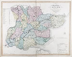
New Map of the County of Essex; Divided into Hundreds; Containing the District Divisions and other Local Arrangements effected by the Reform Bill" - Essex Colchester Chelmsford Southend-on-Sea Clacton
Verlag: London, 1833
Anbieter: Antiquariat Steffen Völkel GmbH, Seubersdorf, Deutschland
Bewertung:
Karte
Antique map in original color from 1833. Size: c. 39 x 47 cm. -- in very good condition. || Original handkolorierte Stahlstich-Karte von 1833. -- gut erhalten. || James Ebden's remarkable county maps are typical of the best maps produced for English atlases at the beginning of the 19th century. Skillfully engraved and beautifully hand colored, they are relatively large compared to the majority of other county maps of the early 19th century. Their size allows for a clearer, more detailed depiction of the regions. The maps show the individual counties and all their major roads. They are accompanied by a legend, further explanations of the symbols used, a mileage scale, and a description of the counties' districts and/or other territorial divisions. || Dies ist ein Original! - Kein Nachdruck! - Keine Kopie! -- This is an original! - No copy! - No reprint! Antique map in original color from 1833. Size: c. 47 x 39 cm. -- in very good condition. || Original handkolorierte Stahlstich-Karte von 1833. -- gut erhalten. || James Ebden's remarkable county maps are typical of the best maps produced for English atlases at the beginning of the 19th century. Skillfully engraved and beautifully hand colored, they are relatively large compared to the majority of other county maps of the early 19th century. Their size allows for a clearer, more detailed depiction of the regions. The maps show the individual counties and all their major roads. They are accompanied by a legend, further explanations of the symbols used, a mileage scale, and a description of the counties' districts and/or other territorial divisions. || Dies ist ein Original! - Kein Nachdruck! - Keine Kopie! -- This is an original! - No copy! - No reprint! Sprache: Englisch.
-
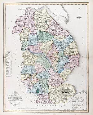
New Map of the County of Lincolnshire; Divided into Hundreds; Containing the District Divisions and other Local Arrangements effected by the Reform Bill" - Lincolnshire Lincoln Grantham Boston Spalding Skegness
Verlag: London, 1833
Anbieter: Antiquariat Steffen Völkel GmbH, Seubersdorf, Deutschland
Bewertung:
Karte
Antique map in original color from 1833. Size: c. 47 x 39 cm. -- in very good condition. || Original handkolorierte Stahlstich-Karte von 1833. -- gut erhalten. || James Ebden's remarkable county maps are typical of the best maps produced for English atlases at the beginning of the 19th century. Skillfully engraved and beautifully hand colored, they are relatively large compared to the majority of other county maps of the early 19th century. Their size allows for a clearer, more detailed depiction of the regions. The maps show the individual counties and all their major roads. They are accompanied by a legend, further explanations of the symbols used, a mileage scale, and a description of the counties' districts and/or other territorial divisions. || Dies ist ein Original! - Kein Nachdruck! - Keine Kopie! -- This is an original! - No copy! - No reprint! Antique map in original color from 1833. Size: c. 47 x 39 cm. -- in very good condition. || Original handkolorierte Stahlstich-Karte von 1833. -- gut erhalten. || James Ebden's remarkable county maps are typical of the best maps produced for English atlases at the beginning of the 19th century. Skillfully engraved and beautifully hand colored, they are relatively large compared to the majority of other county maps of the early 19th century. Their size allows for a clearer, more detailed depiction of the regions. The maps show the individual counties and all their major roads. They are accompanied by a legend, further explanations of the symbols used, a mileage scale, and a description of the counties' districts and/or other territorial divisions. || Dies ist ein Original! - Kein Nachdruck! - Keine Kopie! -- This is an original! - No copy! - No reprint! Sprache: Englisch.
-
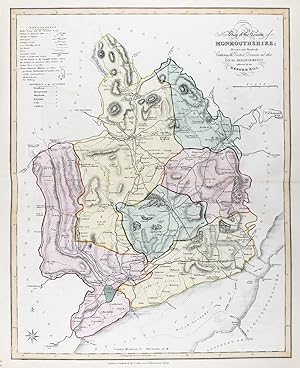
New Map of the County of Monmouthshire; Divided into Hundreds; Containing the District Divisions and other Local Arrangements effected by the Reform Bill" - Monmouthshire Abergavenny Raglan Usk Newport Chepstow
Verlag: London, 1833
Anbieter: Antiquariat Steffen Völkel GmbH, Seubersdorf, Deutschland
Bewertung:
Karte
Antique map in original color from 1833. Size: c. 47 x 39 cm. -- in very good condition. || Original handkolorierte Stahlstich-Karte von 1833. -- gut erhalten. || James Ebden's remarkable county maps are typical of the best maps produced for English atlases at the beginning of the 19th century. Skillfully engraved and beautifully hand colored, they are relatively large compared to the majority of other county maps of the early 19th century. Their size allows for a clearer, more detailed depiction of the regions. The maps show the individual counties and all their major roads. They are accompanied by a legend, further explanations of the symbols used, a mileage scale, and a description of the counties' districts and/or other territorial divisions. || Dies ist ein Original! - Kein Nachdruck! - Keine Kopie! -- This is an original! - No copy! - No reprint! Antique map in original color from 1833. Size: c. 47 x 39 cm. -- in very good condition. || Original handkolorierte Stahlstich-Karte von 1833. -- gut erhalten. || James Ebden's remarkable county maps are typical of the best maps produced for English atlases at the beginning of the 19th century. Skillfully engraved and beautifully hand colored, they are relatively large compared to the majority of other county maps of the early 19th century. Their size allows for a clearer, more detailed depiction of the regions. The maps show the individual counties and all their major roads. They are accompanied by a legend, further explanations of the symbols used, a mileage scale, and a description of the counties' districts and/or other territorial divisions. || Dies ist ein Original! - Kein Nachdruck! - Keine Kopie! -- This is an original! - No copy! - No reprint! Sprache: Englisch.
-
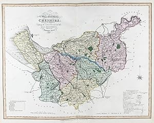
New Map of the County Palatine of Cheshire; Divided into Hundreds; Containing the District Divisions and other Local Arrangements effected by the Reform Bill" - Cheshire Chester Northwich Macelesfield Nantwich
Verlag: London, 1833
Anbieter: Antiquariat Steffen Völkel GmbH, Seubersdorf, Deutschland
Bewertung:
Karte
Antique map in original color from 1833. Size: c. 39 x 47 cm. -- in very good condition. || Original handkolorierte Stahlstich-Karte von 1833. -- gut erhalten. || James Ebden's remarkable county maps are typical of the best maps produced for English atlases at the beginning of the 19th century. Skillfully engraved and beautifully hand colored, they are relatively large compared to the majority of other county maps of the early 19th century. Their size allows for a clearer, more detailed depiction of the regions. The maps show the individual counties and all their major roads. They are accompanied by a legend, further explanations of the symbols used, a mileage scale, and a description of the counties' districts and/or other territorial divisions. || Dies ist ein Original! - Kein Nachdruck! - Keine Kopie! -- This is an original! - No copy! - No reprint! Antique map in original color from 1833. Size: c. 47 x 39 cm. -- in very good condition. || Original handkolorierte Stahlstich-Karte von 1833. -- gut erhalten. || James Ebden's remarkable county maps are typical of the best maps produced for English atlases at the beginning of the 19th century. Skillfully engraved and beautifully hand colored, they are relatively large compared to the majority of other county maps of the early 19th century. Their size allows for a clearer, more detailed depiction of the regions. The maps show the individual counties and all their major roads. They are accompanied by a legend, further explanations of the symbols used, a mileage scale, and a description of the counties' districts and/or other territorial divisions. || Dies ist ein Original! - Kein Nachdruck! - Keine Kopie! -- This is an original! - No copy! - No reprint! Sprache: Englisch.
-
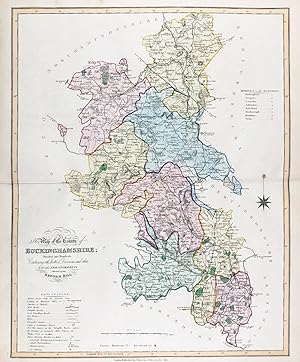
New Map of the County of Buckinghamshire; Divided into Hundreds; Containing the District Divisions and other Local Arrangements effected by the Reform Bill" - Buckinghamshire Buckingham Aylesbury Marlow Slough
Verlag: London, 1833
Anbieter: Antiquariat Steffen Völkel GmbH, Seubersdorf, Deutschland
Bewertung:
Karte
Antique map in original color from 1833. Size: c. 47 x 39 cm. -- in very good condition. || Original handkolorierte Stahlstich-Karte von 1833. -- gut erhalten. || James Ebden's remarkable county maps are typical of the best maps produced for English atlases at the beginning of the 19th century. Skillfully engraved and beautifully hand colored, they are relatively large compared to the majority of other county maps of the early 19th century. Their size allows for a clearer, more detailed depiction of the regions. The maps show the individual counties and all their major roads. They are accompanied by a legend, further explanations of the symbols used, a mileage scale, and a description of the counties' districts and/or other territorial divisions. || Dies ist ein Original! - Kein Nachdruck! - Keine Kopie! -- This is an original! - No copy! - No reprint! Antique map in original color from 1833. Size: c. 47 x 39 cm. -- in very good condition. || Original handkolorierte Stahlstich-Karte von 1833. -- gut erhalten. || James Ebden's remarkable county maps are typical of the best maps produced for English atlases at the beginning of the 19th century. Skillfully engraved and beautifully hand colored, they are relatively large compared to the majority of other county maps of the early 19th century. Their size allows for a clearer, more detailed depiction of the regions. The maps show the individual counties and all their major roads. They are accompanied by a legend, further explanations of the symbols used, a mileage scale, and a description of the counties' districts and/or other territorial divisions. || Dies ist ein Original! - Kein Nachdruck! - Keine Kopie! -- This is an original! - No copy! - No reprint! Sprache: Englisch.
-
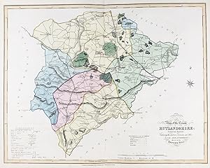
New Map of the County of Rutlandshire; Divided into Hundreds; Containing the District Divisions and other Local Arrangements effected by the Reform Bill" - Rutlandshire Rutland Uppingham Stretton Oakham Ketton
Verlag: London, 1833
Anbieter: Antiquariat Steffen Völkel GmbH, Seubersdorf, Deutschland
Bewertung:
Karte
Antique map in original color from 1833. Size: c. 47 x 39 cm. -- in very good condition. || Original handkolorierte Stahlstich-Karte von 1833. -- gut erhalten. || James Ebden's remarkable county maps are typical of the best maps produced for English atlases at the beginning of the 19th century. Skillfully engraved and beautifully hand colored, they are relatively large compared to the majority of other county maps of the early 19th century. Their size allows for a clearer, more detailed depiction of the regions. The maps show the individual counties and all their major roads. They are accompanied by a legend, further explanations of the symbols used, a mileage scale, and a description of the counties' districts and/or other territorial divisions. || Dies ist ein Original! - Kein Nachdruck! - Keine Kopie! -- This is an original! - No copy! - No reprint! Antique map in original color from 1833. Size: c. 47 x 39 cm. -- in very good condition. || Original handkolorierte Stahlstich-Karte von 1833. -- gut erhalten. || James Ebden's remarkable county maps are typical of the best maps produced for English atlases at the beginning of the 19th century. Skillfully engraved and beautifully hand colored, they are relatively large compared to the majority of other county maps of the early 19th century. Their size allows for a clearer, more detailed depiction of the regions. The maps show the individual counties and all their major roads. They are accompanied by a legend, further explanations of the symbols used, a mileage scale, and a description of the counties' districts and/or other territorial divisions. || Dies ist ein Original! - Kein Nachdruck! - Keine Kopie! -- This is an original! - No copy! - No reprint! Sprache: Englisch.
-
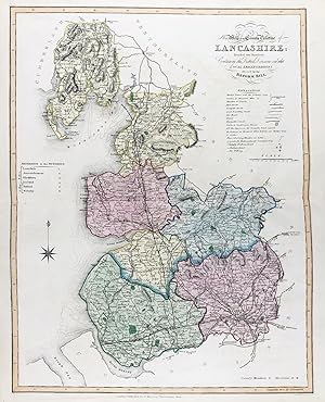
New Map of the County Palatine of Lancashire; Divided into Hundreds; Containing the District Divisions and other Local Arrangements effected by the Reform Bill" - Lancashire Blackpool Blackburn Preston Lancaster Southport
Verlag: London, 1833
Anbieter: Antiquariat Steffen Völkel GmbH, Seubersdorf, Deutschland
Bewertung:
Karte
Antique map in original color from 1833. Size: c. 47 x 39 cm. -- in very good condition. || Original handkolorierte Stahlstich-Karte von 1833. -- gut erhalten. || James Ebden's remarkable county maps are typical of the best maps produced for English atlases at the beginning of the 19th century. Skillfully engraved and beautifully hand colored, they are relatively large compared to the majority of other county maps of the early 19th century. Their size allows for a clearer, more detailed depiction of the regions. The maps show the individual counties and all their major roads. They are accompanied by a legend, further explanations of the symbols used, a mileage scale, and a description of the counties' districts and/or other territorial divisions. || Dies ist ein Original! - Kein Nachdruck! - Keine Kopie! -- This is an original! - No copy! - No reprint! Antique map in original color from 1833. Size: c. 47 x 39 cm. -- in very good condition. || Original handkolorierte Stahlstich-Karte von 1833. -- gut erhalten. || James Ebden's remarkable county maps are typical of the best maps produced for English atlases at the beginning of the 19th century. Skillfully engraved and beautifully hand colored, they are relatively large compared to the majority of other county maps of the early 19th century. Their size allows for a clearer, more detailed depiction of the regions. The maps show the individual counties and all their major roads. They are accompanied by a legend, further explanations of the symbols used, a mileage scale, and a description of the counties' districts and/or other territorial divisions. || Dies ist ein Original! - Kein Nachdruck! - Keine Kopie! -- This is an original! - No copy! - No reprint! Sprache: Englisch.
-
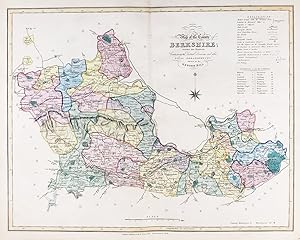
New Map of the County of Berkshire; Divided into Hundreds; Containing the District Divisions and other Local Arrangements effected by the Reform Bill" - Berkshire Newbury Reading Cookham Sandhurst Hungerford
Verlag: London, 1833
Anbieter: Antiquariat Steffen Völkel GmbH, Seubersdorf, Deutschland
Bewertung:
Karte
Antique map in original color from 1833. Size: c. 47 x 39 cm. -- in very good condition. || Original handkolorierte Stahlstich-Karte von 1833. -- gut erhalten. || James Ebden's remarkable county maps are typical of the best maps produced for English atlases at the beginning of the 19th century. Skillfully engraved and beautifully hand colored, they are relatively large compared to the majority of other county maps of the early 19th century. Their size allows for a clearer, more detailed depiction of the regions. The maps show the individual counties and all their major roads. They are accompanied by a legend, further explanations of the symbols used, a mileage scale, and a description of the counties' districts and/or other territorial divisions. || Dies ist ein Original! - Kein Nachdruck! - Keine Kopie! -- This is an original! - No copy! - No reprint! Antique map in original color from 1833. Size: c. 47 x 39 cm. -- in very good condition. || Original handkolorierte Stahlstich-Karte von 1833. -- gut erhalten. || James Ebden's remarkable county maps are typical of the best maps produced for English atlases at the beginning of the 19th century. Skillfully engraved and beautifully hand colored, they are relatively large compared to the majority of other county maps of the early 19th century. Their size allows for a clearer, more detailed depiction of the regions. The maps show the individual counties and all their major roads. They are accompanied by a legend, further explanations of the symbols used, a mileage scale, and a description of the counties' districts and/or other territorial divisions. || Dies ist ein Original! - Kein Nachdruck! - Keine Kopie! -- This is an original! - No copy! - No reprint! Sprache: Englisch.
-
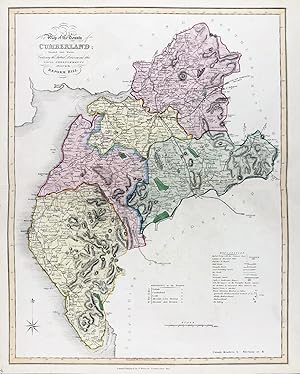
New Map of the County of Cumberland; Divided into Wards; Containing the District Divisions and other Local Arrangements effected by the Reform Bill" - Cumberland Carlisle Maryport Whitehaven Keswick
Verlag: London, 1833
Anbieter: Antiquariat Steffen Völkel GmbH, Seubersdorf, Deutschland
Bewertung:
Karte
Antique map in original color from 1833. Size: c. 47 x 39 cm. -- in very good condition. || Original handkolorierte Stahlstich-Karte von 1833. -- gut erhalten. || James Ebden's remarkable county maps are typical of the best maps produced for English atlases at the beginning of the 19th century. Skillfully engraved and beautifully hand colored, they are relatively large compared to the majority of other county maps of the early 19th century. Their size allows for a clearer, more detailed depiction of the regions. The maps show the individual counties and all their major roads. They are accompanied by a legend, further explanations of the symbols used, a mileage scale, and a description of the counties' districts and/or other territorial divisions. || Dies ist ein Original! - Kein Nachdruck! - Keine Kopie! -- This is an original! - No copy! - No reprint! Antique map in original color from 1833. Size: c. 47 x 39 cm. -- in very good condition. || Original handkolorierte Stahlstich-Karte von 1833. -- gut erhalten. || James Ebden's remarkable county maps are typical of the best maps produced for English atlases at the beginning of the 19th century. Skillfully engraved and beautifully hand colored, they are relatively large compared to the majority of other county maps of the early 19th century. Their size allows for a clearer, more detailed depiction of the regions. The maps show the individual counties and all their major roads. They are accompanied by a legend, further explanations of the symbols used, a mileage scale, and a description of the counties' districts and/or other territorial divisions. || Dies ist ein Original! - Kein Nachdruck! - Keine Kopie! -- This is an original! - No copy! - No reprint! Sprache: Englisch.
-
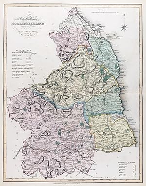
New Map of the County of Northumberland; Divided into Wards; Containing the District Divisions and other Local Arrangements effected by the Reform Bill" - Northumberland Bamburgh Seahouses Alnwick Bellingham
Verlag: London, 1833
Anbieter: Antiquariat Steffen Völkel GmbH, Seubersdorf, Deutschland
Bewertung:
Karte
Antique map in original color from 1833. Size: c. 47 x 39 cm. -- in very good condition. || Original handkolorierte Stahlstich-Karte von 1833. -- gut erhalten. || James Ebden's remarkable county maps are typical of the best maps produced for English atlases at the beginning of the 19th century. Skillfully engraved and beautifully hand colored, they are relatively large compared to the majority of other county maps of the early 19th century. Their size allows for a clearer, more detailed depiction of the regions. The maps show the individual counties and all their major roads. They are accompanied by a legend, further explanations of the symbols used, a mileage scale, and a description of the counties' districts and/or other territorial divisions. || Dies ist ein Original! - Kein Nachdruck! - Keine Kopie! -- This is an original! - No copy! - No reprint! Antique map in original color from 1833. Size: c. 47 x 39 cm. -- in very good condition. || Original handkolorierte Stahlstich-Karte von 1833. -- gut erhalten. || James Ebden's remarkable county maps are typical of the best maps produced for English atlases at the beginning of the 19th century. Skillfully engraved and beautifully hand colored, they are relatively large compared to the majority of other county maps of the early 19th century. Their size allows for a clearer, more detailed depiction of the regions. The maps show the individual counties and all their major roads. They are accompanied by a legend, further explanations of the symbols used, a mileage scale, and a description of the counties' districts and/or other territorial divisions. || Dies ist ein Original! - Kein Nachdruck! - Keine Kopie! -- This is an original! - No copy! - No reprint! Sprache: Englisch.
-
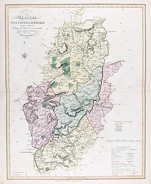
New Map of the County of Nottinghamshire; Divided into Hundreds; Containing the District Divisions and other Local Arrangements effected by the Reform Bill" - Nottinghamshire Nottingham Mansfield Workshop Retford Newark-on-Trent
Verlag: London, 1833
Anbieter: Antiquariat Steffen Völkel GmbH, Seubersdorf, Deutschland
Bewertung:
Karte
Antique map in original color from 1833. Size: c. 47 x 39 cm. -- in very good condition. || Original handkolorierte Stahlstich-Karte von 1833. -- gut erhalten. || James Ebden's remarkable county maps are typical of the best maps produced for English atlases at the beginning of the 19th century. Skillfully engraved and beautifully hand colored, they are relatively large compared to the majority of other county maps of the early 19th century. Their size allows for a clearer, more detailed depiction of the regions. The maps show the individual counties and all their major roads. They are accompanied by a legend, further explanations of the symbols used, a mileage scale, and a description of the counties' districts and/or other territorial divisions. || Dies ist ein Original! - Kein Nachdruck! - Keine Kopie! -- This is an original! - No copy! - No reprint! Antique map in original color from 1833. Size: c. 47 x 39 cm. -- in very good condition. || Original handkolorierte Stahlstich-Karte von 1833. -- gut erhalten. || James Ebden's remarkable county maps are typical of the best maps produced for English atlases at the beginning of the 19th century. Skillfully engraved and beautifully hand colored, they are relatively large compared to the majority of other county maps of the early 19th century. Their size allows for a clearer, more detailed depiction of the regions. The maps show the individual counties and all their major roads. They are accompanied by a legend, further explanations of the symbols used, a mileage scale, and a description of the counties' districts and/or other territorial divisions. || Dies ist ein Original! - Kein Nachdruck! - Keine Kopie! -- This is an original! - No copy! - No reprint! Sprache: Englisch.
-
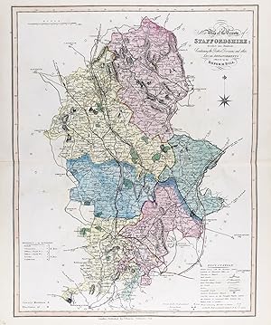
New Map of the County of Staffordshire; Divided into Hundreds; Containing the District Divisions and other Local Arrangements effected by the Reform Bill" - Staffordshire Stafford Stoke-on-Trent Cannock Wolverhampton
Verlag: London, 1833
Anbieter: Antiquariat Steffen Völkel GmbH, Seubersdorf, Deutschland
Bewertung:
Karte
Antique map in original color from 1833. Size: c. 47 x 39 cm. -- in very good condition. || Original handkolorierte Stahlstich-Karte von 1833. -- gut erhalten. || James Ebden's remarkable county maps are typical of the best maps produced for English atlases at the beginning of the 19th century. Skillfully engraved and beautifully hand colored, they are relatively large compared to the majority of other county maps of the early 19th century. Their size allows for a clearer, more detailed depiction of the regions. The maps show the individual counties and all their major roads. They are accompanied by a legend, further explanations of the symbols used, a mileage scale, and a description of the counties' districts and/or other territorial divisions. || Dies ist ein Original! - Kein Nachdruck! - Keine Kopie! -- This is an original! - No copy! - No reprint! Antique map in original color from 1833. Size: c. 47 x 39 cm. -- in very good condition. || Original handkolorierte Stahlstich-Karte von 1833. -- gut erhalten. || James Ebden's remarkable county maps are typical of the best maps produced for English atlases at the beginning of the 19th century. Skillfully engraved and beautifully hand colored, they are relatively large compared to the majority of other county maps of the early 19th century. Their size allows for a clearer, more detailed depiction of the regions. The maps show the individual counties and all their major roads. They are accompanied by a legend, further explanations of the symbols used, a mileage scale, and a description of the counties' districts and/or other territorial divisions. || Dies ist ein Original! - Kein Nachdruck! - Keine Kopie! -- This is an original! - No copy! - No reprint! Sprache: Englisch.
-
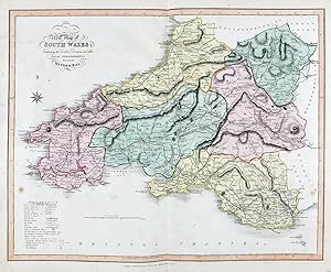
New Map of the South Wales; Containing the District Divisions and other Local Arrangements effected by the Reform Bill" - South Wales Swansea Cardiff Cardigan Fishguard Tenby
Verlag: London, 1833
Anbieter: Antiquariat Steffen Völkel GmbH, Seubersdorf, Deutschland
Bewertung:
Karte
Antique map in original color from 1833. Size: c. 47 x 39 cm. -- partly slightly stained, otherwise in very good condition. || Original handkolorierte Stahlstich-Karte von 1833. -- teils leicht fleckig, sonst gut erhalten. || James Ebden's remarkable county maps are typical of the best maps produced for English atlases at the beginning of the 19th century. Skillfully engraved and beautifully hand colored, they are relatively large compared to the majority of other county maps of the early 19th century. Their size allows for a clearer, more detailed depiction of the regions. The maps show the individual counties and all their major roads. They are accompanied by a legend, further explanations of the symbols used, a mileage scale, and a description of the counties' districts and/or other territorial divisions. || Dies ist ein Original! - Kein Nachdruck! - Keine Kopie! -- This is an original! - No copy! - No reprint! Antique map in original color from 1833. Size: c. 47 x 39 cm. -- in very good condition. || Original handkolorierte Stahlstich-Karte von 1833. -- gut erhalten. || James Ebden's remarkable county maps are typical of the best maps produced for English atlases at the beginning of the 19th century. Skillfully engraved and beautifully hand colored, they are relatively large compared to the majority of other county maps of the early 19th century. Their size allows for a clearer, more detailed depiction of the regions. The maps show the individual counties and all their major roads. They are accompanied by a legend, further explanations of the symbols used, a mileage scale, and a description of the counties' districts and/or other territorial divisions. || Dies ist ein Original! - Kein Nachdruck! - Keine Kopie! -- This is an original! - No copy! - No reprint! Sprache: Englisch.
-
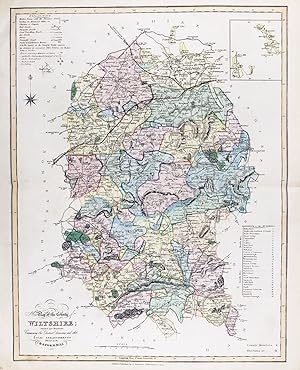
New Map of the County of Wiltshire; Divided into Hundreds; Containing the District Divisions and other Local Arrangements effected by the Reform Bill" - Wiltshire Marlborough Salisbury Warminster Chippenham
Verlag: London, 1833
Anbieter: Antiquariat Steffen Völkel GmbH, Seubersdorf, Deutschland
Bewertung:
Karte
Antique map in original color from 1833. Size: c. 47 x 39 cm. -- in very good condition. || Original handkolorierte Stahlstich-Karte von 1833. -- gut erhalten. || James Ebden's remarkable county maps are typical of the best maps produced for English atlases at the beginning of the 19th century. Skillfully engraved and beautifully hand colored, they are relatively large compared to the majority of other county maps of the early 19th century. Their size allows for a clearer, more detailed depiction of the regions. The maps show the individual counties and all their major roads. They are accompanied by a legend, further explanations of the symbols used, a mileage scale, and a description of the counties' districts and/or other territorial divisions. || Dies ist ein Original! - Kein Nachdruck! - Keine Kopie! -- This is an original! - No copy! - No reprint! Antique map in original color from 1833. Size: c. 47 x 39 cm. -- in very good condition. || Original handkolorierte Stahlstich-Karte von 1833. -- gut erhalten. || James Ebden's remarkable county maps are typical of the best maps produced for English atlases at the beginning of the 19th century. Skillfully engraved and beautifully hand colored, they are relatively large compared to the majority of other county maps of the early 19th century. Their size allows for a clearer, more detailed depiction of the regions. The maps show the individual counties and all their major roads. They are accompanied by a legend, further explanations of the symbols used, a mileage scale, and a description of the counties' districts and/or other territorial divisions. || Dies ist ein Original! - Kein Nachdruck! - Keine Kopie! -- This is an original! - No copy! - No reprint! Sprache: Englisch.
-
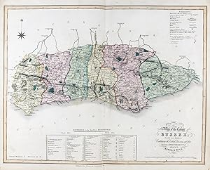
New Map of the County of Sussex; Divided into Hundreds; Containing the District Divisions and other Local Arrangements effected by the Reform Bill" - Sussex Eastburne Newhaven Hastings Rye
Verlag: London, 1833
Anbieter: Antiquariat Steffen Völkel GmbH, Seubersdorf, Deutschland
Bewertung:
Karte
Antique map in original color from 1833. Size: c. 39 x 47 cm. -- in very good condition. || Original handkolorierte Stahlstich-Karte von 1833. -- gut erhalten. || James Ebden's remarkable county maps are typical of the best maps produced for English atlases at the beginning of the 19th century. Skillfully engraved and beautifully hand colored, they are relatively large compared to the majority of other county maps of the early 19th century. Their size allows for a clearer, more detailed depiction of the regions. The maps show the individual counties and all their major roads. They are accompanied by a legend, further explanations of the symbols used, a mileage scale, and a description of the counties' districts and/or other territorial divisions. || Dies ist ein Original! - Kein Nachdruck! - Keine Kopie! -- This is an original! - No copy! - No reprint! Antique map in original color from 1833. Size: c. 47 x 39 cm. -- in very good condition. || Original handkolorierte Stahlstich-Karte von 1833. -- gut erhalten. || James Ebden's remarkable county maps are typical of the best maps produced for English atlases at the beginning of the 19th century. Skillfully engraved and beautifully hand colored, they are relatively large compared to the majority of other county maps of the early 19th century. Their size allows for a clearer, more detailed depiction of the regions. The maps show the individual counties and all their major roads. They are accompanied by a legend, further explanations of the symbols used, a mileage scale, and a description of the counties' districts and/or other territorial divisions. || Dies ist ein Original! - Kein Nachdruck! - Keine Kopie! -- This is an original! - No copy! - No reprint! Sprache: Englisch.
-
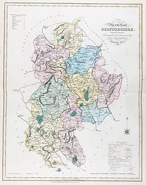
New Map of the County of Bedfordshire; Divided into Hundreds; Containing the District Divisions and other Local Arrangements effected by the Reform Bill" - Bedfordshire Bedford Luton
Verlag: London, 1833
Anbieter: Antiquariat Steffen Völkel GmbH, Seubersdorf, Deutschland
Bewertung:
Karte
Antique map in original color from 1833. Size: c. 47 x 39 cm. -- in very good condition. || Original handkolorierte Stahlstich-Karte von 1833. -- gut erhalten. || James Ebden's remarkable county maps are typical of the best maps produced for English atlases at the beginning of the 19th century. Skillfully engraved and beautifully hand colored, they are relatively large compared to the majority of other county maps of the early 19th century. Their size allows for a clearer, more detailed depiction of the regions. The maps show the individual counties and all their major roads. They are accompanied by a legend, further explanations of the symbols used, a mileage scale, and a description of the counties' districts and/or other territorial divisions. || Dies ist ein Original! - Kein Nachdruck! - Keine Kopie! -- This is an original! - No copy! - No reprint! Antique map in original color from 1833. Size: c. 47 x 39 cm. -- in very good condition. || Original handkolorierte Stahlstich-Karte von 1833. -- gut erhalten. || James Ebden's remarkable county maps are typical of the best maps produced for English atlases at the beginning of the 19th century. Skillfully engraved and beautifully hand colored, they are relatively large compared to the majority of other county maps of the early 19th century. Their size allows for a clearer, more detailed depiction of the regions. The maps show the individual counties and all their major roads. They are accompanied by a legend, further explanations of the symbols used, a mileage scale, and a description of the counties' districts and/or other territorial divisions. || Dies ist ein Original! - Kein Nachdruck! - Keine Kopie! -- This is an original! - No copy! - No reprint! Sprache: Englisch.