Gesamtpreis (1 Artikel Artikel):
Versandziel:

edmond halley (35 Ergebnisse)
Direkt zu den wichtigsten Suchergebnissen
Produktart
- Alle Product Types
- Bücher (30)
- Magazine & Zeitschriften
- Comics
- Noten
- Kunst, Grafik & Poster (2)
- Fotografien
- Karten (3)
- Manuskripte & Papierantiquitäten
Zustand
Einband
Weitere Eigenschaften
Gratisversand
- Versand nach USA gratis
Land des Verkäufers
Verkäuferbewertung
-

Die B?cher Des Apollonius Von Perga De Sectione Rationis
Verlag: Nabu Press, 2013
ISBN 10: 1294286021ISBN 13: 9781294286028
Buch
Paperback. Zustand: Used; Very Good. Dispatched, from the UK, within 48 hours of ordering. Though second-hand, the book is still in very good shape. Minimal signs of usage may include very minor creasing on the cover or on the spine. Grubby book may have mild dirt or some staining, mostly on the edges of pages.
-
The Three Voyages of Edmond Halley in the Paramore, 1698-1701: Volume I (Series II, Volume 156)
Verlag: Hakluyt Society, 1981
ISBN 10: 0904180026ISBN 13: 9780904180022
Buch
Hardcover. Zustand: Good.
-

The Three Voyages of Edmond Halley in the Paramore, 1698-1701. (Second Series. No. 156&157). In Two Volumes
Verlag: London. The Hakluyt Society. 1981, 1981
Anbieter: J. Patrick McGahern Books Inc. (ABAC), Ottawa, ON, Kanada
Verbandsmitglied: ABAC ILAB IOBA
Bewertung:

Hardcover. 8VO, 21.5cm, 392p., with 15 illustrations , 3 folding maps, appendices, bibliography, index, light blue cloth, gilt spine titles & cover logos, a fine set in fine jackets (s15). - Commanding HMS Paramore, Edmund Halley undertook what are considered the first sea journeys for purely scientific purposes; the first two voyages were to test his geomagnetical theories, the third to investigate tidal phenomena. Volume two is a portfolio of maps.
-
The Three Voyages of Edmond Halley in the Paramore, 1698 1701. (Second Series. No. 156)
Verlag: London. The Hakluyt Society. 1981, 1981
Anbieter: J. Patrick McGahern Books Inc. (ABAC), Ottawa, ON, Kanada
Verbandsmitglied: ABAC ILAB IOBA
Bewertung:
Hardcover. 8VO, 21.5cm, 392p., with 15 illustrations, appendices, bibliography, index, light blue cloth, gilt spine titles & cover logos, a fine copy. (Tr). Commanding HMS Paramore, Edmund Halley undertook what are considered the first sea journeys for purely scientific purposes; the first two voyages were to test his geomagnetical theories, the third to investigate tidal phenomena.
-
The Three Voyages of Edmond Halley in the Paramore 1698-1701. Vol. I.
Anbieter: Antiquariaat A. Kok & Zn. B.V., Amsterdam, Niederlande
Bewertung:

London, 1981. Vol. 1 (of 2). 392 pp. Ills. Hardcover, d./j. (The Hakluyt society, 2nd series, vols 156).Only the text volume. - Without the small portfolio with the three loose folding maps.
-
The Three Voyages of Edmond Halley in the Paramore 1698-1701.
Anbieter: Antiquariaat A. Kok & Zn. B.V., Amsterdam, Niederlande
Bewertung:
London, 1981. 2 vols. 392 pp. 3 loose fold. maps. Uniform hardcovers, d./j. - Dustjackets with light shelfwear. (Works issued by The Hakluyt society, 2nd series, vols 156 & 157).Complete set.
-
Halley Edmond -Engraved Portrait
Erscheinungsdatum: 1833
Anbieter: K Books Ltd ABA ILAB, York, YORKS, Vereinigtes Königreich
Verbandsmitglied: ABA ILAB PBFA
Bewertung:
Buch
No Binding. Zustand: Very Good. A splendid original antique engraved portrait . Mounted (matted) and ready to frame . Engraved portion approx. 5 x 5 inches, 13 x 13 cms. Very good condition. Printed in 1833. Rather attractive and a fine likeness of halley.
-
Halley, Edmond - an Engraved Portrait
Anbieter: K Books Ltd ABA ILAB, York, YORKS, Vereinigtes Königreich
Verbandsmitglied: ABA ILAB PBFA
Bewertung:
Buch
No Binding. Zustand: Very Good. A splendid engraved portrait, printed in circa 1880. Mounted and ready to frame. This is an excellent opportunity to purchase an attractive and decorative engraved portrait.
-

Zustand: Sehr gut. Zustand: Sehr gut - Gepflegter, sauberer Zustand. | Seiten: 400 | Sprache: Englisch.
-

Miscellanea Curiosa, Vol. 2 : Containing a Collection of Some of the Principal Phenomena in Nature, Accounted for by the Greatest Philosophers of This Age; To Which Is Added, the Laws of Stereographick Projection (Classic Reprint)
Verlag: Forgotten Books, 2017
ISBN 10: 0282406816ISBN 13: 9780282406813
Buch
Zustand: Hervorragend. Zustand: Hervorragend | Seiten: 408 | Sprache: Englisch.
-

Zustand: Sehr gut. Zustand: Sehr gut - Gepflegter, sauberer Zustand. | Seiten: 428 | Sprache: Englisch.
-
A synopsis of the astronomy of comets. By Edmund Halley, . Translated from the original, printed at Oxford.
Verlag: Books on Demand|Gale ECCO, Print Editions, 2010
ISBN 10: 1140756877ISBN 13: 9781140756873
Buch
Zustand: New. The 18th century was a wealth of knowledge, exploration and rapidly growing technology and expanding record-keeping made possible by advances in the printing press. In its determination to preserve the century of revolution, Gale initiated a revolution of i.
-

Halley. From an original Picture ascribed to Dahl in the possession of the Royal Society. Halbfigur in Professorentalar in seiner Bibliothek. Stahlstich von Fry um 1840
Verlag: London: Charles Knight under the Superintendance of the Society for the Diffusion of Useful Knowledge um, 1840
Anbieter: historicArt Antiquariat & Kunsthandlung, Wiesbaden-Breckenheim, Deutschland
Bewertung:
Kunst / Grafik / Poster Erstausgabe Signiert
1. Original-Stahlstich von Fry (in der Platte signiert) auf rückseitig unbedrucktem Büttenkarton, bildliche Darstellung ca. 13 x 10 cm, Kartongröße ca. 26 x 1 cm, sauber und sehr gut erhalten 2100 gr.
-

A Synopsis of the Astronomy of Comets. by Edmund Halley, . Translated from the Original, Printed at Oxford
Verlag: Gale Ecco, Print Editions, 2018
ISBN 10: 1379383269ISBN 13: 9781379383260
Buch
Einband - fest (Hardcover). Zustand: New.
-

0. Sprache: Deutschu.
-

Tables Astronomiques De M. Halley, Pour Les Plančtes Et Les Comčtes, Réduites Au Nouveau Stile & Méridien De Paris, Augmentées De Plusieurs Tables Nou
Verlag: WENTWORTH PR, 2018
ISBN 10: 0270648526ISBN 13: 9780270648522
Buch
Gebunden. Zustand: New.
-

Sieben Bücher Ueber Kegelschnitte
Verlag: WENTWORTH PR, 2018
ISBN 10: 0270803378ISBN 13: 9780270803372
Buch
Gebunden. Zustand: New.
-

A Voyage to the South-Sea, and Along the Coasts of Chili and Peru, in the Years 1712, 1713, and 1714
Verlag: Legare Street Press, 2021
ISBN 10: 1015388957ISBN 13: 9781015388956
Buch
Zustand: New.
-

Zustand: Sehr gut. Zustand: Sehr gut - Gepflegter, sauberer Zustand. | Seiten: 558 | Sprache: Englisch.
-
CORRESPONDENCE AND PAPERS OF EDMOND HALLEY PRECEDED BY AN UNPUBLISHED
Erscheinungsdatum: 1937
Anbieter: Boston Book Company, Inc. ABAA, Boston, MA, USA
Verbandsmitglied: ABAA ILAB SNEAB
Bewertung:

HALLEY, Edmond, ed. Eugene Fairfield MACPIKE. CORRESPONDENCE AND PAPERS OF EDMOND HALLEY PRECEDED BY AN UNPUBLISHED MEMOIR OF HIS LIFE BY ONE OF HIS CONTEMPORARIES, AND THE 'ELOGE' BY D'ORTOUS DE MAIRAN. London: Taylor and Francis (1937). History of Science Society Publications: New Series II. 300 pp. 8vo., blue cloth stamped in gilt on spine. Spine and corners gently bumped. Light rubbing and minor sunning to cloth. Offset tanning to front free endpaper. Reissue of Oxford University Press edition of 1932. Interior clean and tight. Halftone plates, some folding, fine. Figures in the text.
-
éloges des Académiciens de L'Académie Riyale des Sciences, morts dans les années 1741 , 1742 , & 1743.
Erstausgabe
Paris, chez Durand, Libraire, au Griffon, 1747, in-8°, 16 x 9,5 cm, (12)nn pp (with engraved allagorical frontispiece ) + 360 pp (complete), bound in contemporary full calf, raised gilt spine, marbled endpapers, edges painted red, some wear at extremeties but still a fine copy. First edition. Text in French. Contains the biographies and bibliographies of e.g. the medical doctor François Petit , the chemist Nicolas Lemery and the english astronomer Edmond Halley (1656 - 1742). [ science ; biography ; astronomy ; cosmology ; comets ; ].
-
The Variation of the Compass" Containing 1719 Observations to, in, and from, the East Indies, Guinea, West Indies, and Mediterranean, with the Latitudes and Longitudes at the Time of Observation. The Longitude for the Most Part Reckoned from the Merid.
London, Lockyer Davis, 1776. 4to. In recent marbled paper wrappers. In "Philosophical Transactions of The Royal Society", vol 66. All leaves reinforced in margin, light miscolouring to first and last leaves. Otherwise fine. VII, (1), 72 pp.
-
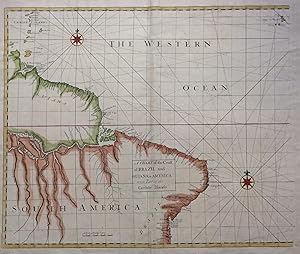
A Chart of the Coast of Brazil and Guiana in America: with Part of the Caribbe Islands
Verlag: James and John Knapton, 1728
Anbieter: Argosy Book Store, ABAA, ILAB, New York, NY, USA
Bewertung:
unbound. First. Sea Chart. Colored engraving. Sheet measures 21 1/4" x 25". Image measures 19 1/2" x 23 1/2". This stunning map of the western hemisphere depicts Guiana and Brazil in South America presented on Edward Wright's projection, also called a globular projection. It features rhumb lines to facilitate navigation. The map focuses more on the coastlines rather than the interiors. This chart was made for the 1728 issued of "Atlas maritimus & commercialis, or, A general view of the world, so far as relates to trade and navigation". The atlas which was meant to compete with Mount and Page's popular "English Pilot", was a collaboration between some of the leading cartographers of the time, including Sir Edmund Halley, John Senex, Nathaniel Cutler, Steven Parker and Daniel Defoe. The atlas unfortunately failed to achieve commercial success as great as its rival, making this a hard-to-find map.The map is in good condition with minor wear along the original folds and overall toning. Some toning over joint. Original plate mark is visible.John Senex (1678-1740) was a kind of Renaissance man of the 18th-century map world, working at times as a scholar, surveyor, engraver, astrologer, book seller and publisher of maps, atlases and globes. In a short period, he developed from an apprentice into one of the most important cartographers of the period and became a Fellow of the Royal Society of London, as well as Official Geographer to Queen Anne of Great Britain. Although well regarded for his pocket-size maps, Senex is probably best known for his globes, which display a knowledge of astronomy equal to the skill of their craftsmanship. After his death in 1740 his wife Mary continued his business and continued to produce and sell cartographic works of high quality. Together, their work represents a successful and valuable partnership in 18th-century mapmaking and publishing. Sir Edmond Halley (1656--1742) was an English astronomer, geophysicist, mathematician, meteorologist, and physicist known for computing the orbit of the eponymous Halley's Comet. He was the second Astronomer Royal in Britain after John Flamsteed. Globular Projection maps were invented by Halley, Harris and Senex. This is a wonderful example of their collaborative work.
-
A Globular Chart shewing the errors of Plain, and the Deficiencyes of Mercators Sailing, and Discovering the true Navigation according to the Globe
Verlag: James Knapton, London, 1728
Anbieter: Argosy Book Store, ABAA, ILAB, New York, NY, USA
Bewertung:
Sea Chart. Uncolored engraving. An alternate projection of the globe as a flat map to the prevailing Mercator Projection. Includes rhumb lines and coastal details. From Atlas Maritimus, a commercial sea atlas was published as a guide to British global commerce. Good condition with some stains along lower center fold. Sir Edmond Halley (1656--1742) was an English astronomer, geophysicist, mathematician, meteorologist, and physicist known for computing the orbit of the eponymous Halley's Comet. He was the second Astronomer Royal in Britain after John Flamsteed. John Senex (1678 to1740) was an English cartographer, engraver and explorer who worked prominently in the 18th century. He is especially known for his maps of the world, some of which have added elevations and minuscule detailed engravings. Globular Projection maps were invented by Halley, Harris and Senex.
-
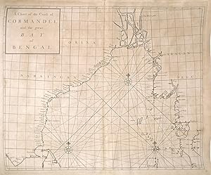
A Chart of the Coast of Cormandel and the Great Bay of Bengal
Verlag: James and John Knapton, London, 1728
Anbieter: Argosy Book Store, ABAA, ILAB, New York, NY, USA
Bewertung:
unbound. Sea Chart. Uncolored engraving.19 x 22 1/2 inches. This beautiful early sea chart of the Coromandel coast in Southeast India covers the entire eastern coast of India as well as the western coast of Burma (Myanmar) and southern Thailand. Extends from modern day Kanyakumari north to include the Ganges River Delta, the coast of Bangladesh and then south along western coast of Burma or Myanmar to Thailand. The northern parts of Sri Lanka or Ceylon are also included. The chart notes several villages and settlements along the coast. Islands, coastal features, rhumb lines and other geographical features are also noted.The Coromandel Coast was one of the most important regions for the British, Dutch, French, Danish and Portuguese during this time as much of the Indian trade was controlled through its various harbors and ports.This chart was made by Senex for the 1728 issued of "Atlas maritimus & commercialis, or, A general view of the world, so far as relates to trade and navigation". The atlas which was meant to compete with Mount and Page's popular "English Pilot", was a collaboration between some of the leading cartographers of the time, including Sir Edmund Halley, John Senex, Nathaniel Cutler, Steven Parker and Daniel Defoe. The atlas unfortunately failed to achieve commercial success as great as its rival, making this a hard-to-find map.The map is in good condition with minor wear along the original centerfold and overall toning. Map is lined with archival paper.John Senex (1678-1740) was a kind of Renaissance man of the 18th-century map world, working at times as a scholar, surveyor, engraver, astrologer, book seller and publisher of maps, atlases and globes. In a short period, he developed from an apprentice into one of the most important cartographers of the period and became a Fellow of the Royal Society of London, as well as Official Geographer to Queen Anne of Great Britain. Although well regarded for his pocket-size maps, Senex is probably best known for his globes, which display a knowledge of astronomy equal to the skill of their craftsmanship. After his death in 1740 his wife Mary continued his business and continued to produce and sell cartographic works of high quality. Together, their work represents a successful and valuable partnership in 18th-century mapmaking and publishing. Sir Edmond Halley (1656--1742) was an English astronomer, geophysicist, mathematician, meteorologist, and physicist known for computing the orbit of the eponymous Halley's Comet. He was the second Astronomer Royal in Britain after John Flamsteed. Globular Projection maps were invented by Halley, Harris and Senex. This is a wonderful example of their collaborative work.
-
Tables astronomiques de M. Hallei
Verlag: Durand & Pissot, Paris, 1754
Erstausgabe
Couverture rigide. Zustand: Trčs bon. Edition originale. Plein veau de l'époque, dos lisses ornés et dorés. Reliures dépareillées. Deux volumes in-8 (250x164 mm), xii-lxxxviii-328 pages et 5 planches dépliantes (3 tableaux, 1 planche et 1 carte) / viii-200 pages. Coiffe de tęte du volume I accidentée. Mors fragile au volume I. Premičre édition en français (malgré la mention de seconde édition) des tables astronomiques de Halley aprčs l'originale en latin de 1749. Le premier volume supervisé par Chappe d'Auteroche présente les tables du Soleil et de la Lune avec des additions par Le Monnier. Le second volume supervisé par Jérôme De Lalande présente les tables des plančtes et des comčtes, et est précédé d'une traduction de la théorie des comčtes par Halley. Au texte de Halley, Lalande présente pour la premičre fois son récit du retour de la comčte de 1682 en 1759. Le travail de Lalande est en effet publié peu aprčs le retour de la comčte de 1682 (dite dorénavant "comčte de Halley") dont le savant anglais avait prévu, d'aprčs les équations newtoniennes, le passage dans le ciel terrien ŕ la fin de l'année 1758 ou au début de l'année 1759. ce qui fut en effet le cas Cette preuve expérimentale des théories de Newton fut d'une importance capitale dans l'histoire des sciences. References : Houzeau-Lancaster [12796 : "Le traducteur, (Chappe d'Auteroche), a ajouté un exposé des méthodes pour trouver la longitude en mer et des observations sur la lune faites en 1736 et 1737. Le deuxičme volume a été publié par de Lalande qui y a insérer les tables des satellites de Jupiter de Wargentin et une histoire de la comčte de Halley"], Norman [981 for the first 1st ed. (tabulae astronomicae. 1749) : "This posthumously published astronomical tables include Halley's calculations relating to the so-called ?long inequality' of Jupiter and Saturn, caused by the deacceleration of Saturn and the increasing acceleration of Jupiter. Halley correctly theorized that this phenomenon might be the result of a gravitational attraction between the two planets. The edition also contains the third Latin edition of the Synopsis astronomiae cometicae "]. ________________________________________________________________ ___________________ ______________________________ENGLISH_DESCRIPTION : Modern quarter chagreen, spine in five compartments. Bindings slightly differents. 8vo (250x164 mm), xii-lxxxviii-328 pages and 5 folding plates (3 tables, 1 plate and 1 map) / viii-200 pages. Headcap worn on volume I. Joint fragile on volume I. First edition in French of Halley's astronomical tables after the original in Latin of 1749. The first volume supervised by Chappe d'Auteroche presents the tables of the Sun and the Moon with additions by Le Monnier. The second volume supervised by Jérôme De Lalande presents the tables of planets and comets, and is preceded by a translation of the theory of comets by Halley. More than the Halley's text, Lalande presents for the first time his account of the return of the 1682 comet in 1759. Lalande's work is indeed published shortly after the return of the 1682 comet (henceforth called "Halley's comet") whose the English scientist had predicted, according to the Newtonian equations, the passage in the terrestrial sky at the end of the year 1758 or the beginning of the year 1759. which was indeed the case. This experimental proof of the theories of Newton was a milestone in astronomy. References : Houzeau-Lancaster [12796 : "Le traducteur, (Chappe d'Auteroche), a ajouté un exposé des méthodes pour trouver la longitude en mer et des observations sur la lune faites en 1736 et 1737. Le deuxičme volume a été publié par de Lalande qui y a insérer les tables des satellites de Jupiter de Wargentin et une histoire de la comčte de Halley"], Norman [981 for the first 1st ed. (tabulae astronomicae. 1749) : "This posthumously published astronomical tables include Halley's calculations relating to the so-called ?long inequality' of Jupiter and Saturn, caused by the deacceleration of Saturn and the increasing acceleration of Jupiter. Halley correctly theorized that this phenomenon might be the result of a gravitational attraction between the two planets. The edition also contains the third Latin edition of the Synopsis astronomiae cometicae "]. 945g.
-

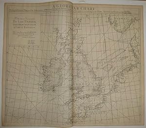
A General Chart of England to Russia Including the Baltick Sea.
Verlag: London J. & J. Knapton W. & J. Innys, 1728
Anbieter: Shapero Rare Books, London, Vereinigtes Königreich
Verbandsmitglied: ABA ILAB PBFA
Bewertung:
Karte
Six engraved sea charts on one double-page map sheet. Good condition. Dimensions: 50 x 61 cm. Published in the 'Atlas maritimus & commercialis: or, a General View of the World, so far as Relates to Trade & Navigation'. The Atlas maritius can be used as an index of English trading activity at this period, since detailed insets and harbour plans emphasise those areas of greatest commercial significance. Although the author of the text is anonymous, Daniel Defoe is thought to have contributed to it, and Halley, the Astronomer-Royal, added a prefatory note discussing the use of the charts; it is therefore sometimes catalogued under his name. It has also been attributed to Harris, Senex and Wilson, those name appears on one chart. Senex was certainly responsible for one of the atlas's innovations, the globular chart of Western Europe whose projection according to the title-page was "authorizedby letters patent". The atlas was purely commercial and was not a real rival to the 'English Pilot': unlike the Pilot it compressed global coverage into one book, as well as describing the the south and west coast of America, omitted by the former.
-
![Bild des Verkäufers für [A Chart of the White Sea and Gulf of Finland] [;] A Chart of the Sound [;] A Map of the Rivers Elbe and Weser [;] The River Duna and the Harbour of Archangel. zum Verkauf von Shapero Rare Books](https://pictures.abebooks.com/inventory/md/md22591798704.jpg)
[A Chart of the White Sea and Gulf of Finland] [;] A Chart of the Sound [;] A Map of the Rivers Elbe and Weser [;] The River Duna and the Harbour of Archangel.
Verlag: J. & J. Knapton W. & J. Innys London, 1728
Anbieter: Shapero Rare Books, London, Vereinigtes Königreich
Verbandsmitglied: ABA ILAB PBFA
Bewertung:
Karte
Four engraved sea charts on one double-page map sheet. Good condition. Dimensions: 50 x 61 cm. Published in the 'Atlas maritimus & commercialis: or, a General View of the World, so far as Relates to Trade & Navigation'. The Atlas maritimus can be used as an index of English trading activity at this period, since detailed insets and harbour plans emphasise those areas of greatest commercial significance. Although the author of the text is anonymous, Daniel Defoe is thought to have contributed to it, and Halley, the Astronomer-Royal, added a prefatory note discussing the use of the charts; it is therefore sometimes catalogued under his name. It has also been attributed to Harris, Senex and Wilson, those name appears on one chart. Senex was certainly responsible for one of the atlas's innovations, the globular chart of Western Europe whose projection according to the title-page was "authorized by letters patent". The atlas was purely commercial and was not a real rival to the 'English Pilot': unlike the Pilot it compressed global coverage into one book, as well as describing the the south and west coast of America, omitted by the former.
-

Astronomical Tables with Precepts both in English and Latin for Computing the Places of the Sun, Moon, Planets, and Comets.
Verlag: Printed for William Innys, London, 1752
First edition in English of Halley's classic work. Quarto, bound in contemporary full calf, gilt titles to the spine, gilt embossed stamp of The Society of Writers to the Signet on the front and rear panel, copper-engraved frontispiece portrait. Edited by John Bevis. In very good condition with light rubbing and wear. Astronomical Tables contains Halley's discovery of the secular inequality in the moon's mean motion and of the long inequality of Jupiter and Saturn, also a reprint of his famous Synopsis Astronomiae Cometicae which founded the modern science of astronomy and comets, and in which Halley identified the comets of 1531, 1607, and 1692 ("Halley's Comet") as one and the same.
-
Zodiacus Stellatus Fixas omnes Hactenus cognitas ad quas lunae appulsus ullibi terrarum telescopio observari potrunt complexus.
Verlag: Printed for John Bowles, Robert Sayer, and Carrington Bowles, [c1768], London,, 1768
Anbieter: Daniel Crouch Rare Books Ltd, London, Vereinigtes Königreich
Verbandsmitglied: ABA ILAB PBFA
Bewertung:

Karte
Halley's Zodiacus Stellatus Large folio (670 by 420 mm), engraved charts on two sheets, quarter buckram, red marbled paper wrappers, a few nicks and tears. Senex's 'Zodiacus Stellatus' was first published in 1718. A catalogue issued in that year records "Just Finish'd. 1. A New and Exact Map of the Zodiack on two Imperial Sheets, wherein the Stars are laid down from the best and latest Observations, together with an Explanation of its Uses both in Astronomy, and for Determining the Longitude at Sea", but the first appearance can be narrowed down from two advertisements placed in the 'Post Boy' (issue 4477) for 5th-8th April, 1718, and repeated in the subsequent issue: "This Day is publish'd, [printer's symbols] Zodiacus Stellatus fixas omnes hactenus cognitas, ad quas Lunć appulsus ullibi terrarum Telescopio observari poterunt, complexus. Or, An exact Description of all the fix'd Stars, to which the Moon or Planets can at any time apply, carefully laid down on two large sheets, from the British Catalogue of Stars lately publish'd; being of use to all Lovers of Astronomy, and particularly to such as may be desirous to put in Practice the Art of finding the Longitude by Help of the Moon." These two announcements contain valuable information about the sources and making of the star chart not found on the chart itself, which explain the importance of the delineation. The 'Zodiacus Stellatus' has a chequered past. John Flamsteed, the Astronomer Royal, was a perfectionist; as such, he was determined that his material should not be published until he was satisfied with its accuracy, a day which never quite arrived. However, in 1712, under pressure from Isaac Newton and Edmond Halley (among others), he provided the Royal Society with a manuscript copy of his catalogue of stars and an explanatory text, giving them permission to edit the text (but not the catalogue) for publication. Instead, Halley published the Catalogue of Stars without Flamsteed's permission. An enraged Flamsteed responded by buying every copy of the book he could find (about three hundred out of the four hundred printed) and destroying them all. Subsequently, Halley took the raw data from the catalogue and constructed a star chart, the 'Zodiacus Stellatus', from Flamsteed's observations, which was published under Senex's name. In a letter from one of Flamsteed's assistants to another from 1720, Joseph Crosthwaite commented: ". Senex is so much a tool of Dr. Halley's, and affronted Mr. Flamsteed so much in his lifetime by engraving the 'Zodiacus Stellatus', and putting his own name to it, in order to screen Dr. Halley from the law, that I am afraid he is not to be trusted." (quoted by Warner, 'The Sky Explored', p.242). As Crosthwaite noted, the map was issued without credit either to Flamsteed or Halley, but Senex's catalogue description makes the link clear. "The 'Zodiacus Stellatus' depicts the "zodiac constellations in three long strips arranged vertically over two pages [i.e. sheets]. Each sheet was centred 8 degrees above and below the ecliptic using a cylindrical projection with geocentric orientation" [Kanas, 'Star Charts', p.206]. It was the second European printed zodiac chart but its basis on Flamsteed's authoritative observations made it far superior to its predecessor, and it remained in wide usage for many decades to come.