Gesamtpreis (1 Artikel Artikel):
Versandziel:

findlay alex (20 Ergebnisse)
Direkt zu den wichtigsten Suchergebnissen
Produktart
- Alle Produktarten
- Bücher (10)
- Magazine & Zeitschriften
- Comics
- Noten
- Kunst, Grafik & Poster (1)
- Fotografien
- Karten (9)
-
Manuskripte &
Papierantiquitäten
Zustand
- Alle
- Neu
- Antiquarisch/Gebraucht
Einband
Weitere Eigenschaften
- Erstausgabe (1)
- Signiert
- Schutzumschlag
- Angebotsfoto (12)
Land des Verkäufers
Verkäuferbewertung
-

Einführung in die Phasenlehre und ihre Anwendungen. Handbuch der angewandten physikalischen Chemie in Einzeldarstellungen. Hrsgg. v. Dr. Georg Bredig. Band VI.
Verlag: Leipzig: Verlag v Johann Ambrosius Barth, 1907
VII, 224 S. 8°, kasch. HLn., goldgepräg. Rücken, hist. Bibl.-etik., marm. Deckenbezug u. Buchschnitt. Einbandbezug hint. mit gr. Fehlstelle. Schriftzug im Titel. Papier etw. gebräunt. Sonst sehr gut und saube erhaltenes Exemplar. Bibliotheksexemplar mit den üblichen Kennzeichnungen in Buchschnitt, Vorsatz und Titel. 800 gr.
-
Hardcover. Zustand: Poor. No Jacket. 1st Edition. boards are chipped, torn and worn. tanning, soiling and foxing. ownership inscription and sticker. poor copy.[S.K]. Our orders are shipped using tracked courier delivery services.
-
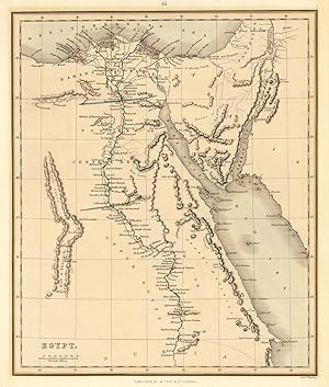
Egypt.
Verlag: Alexander Findlay, London, 1843
Anbieter: Antiquariat Reinhold Berg eK Inh. R.Berg, Regensburg, Deutschland
Bewertung:

Karte
Other. Steel engraving,hand colored in outline when published. Nice and detailed map of Egypt with engraved place names, rivers and political borders. Drawn and engraved by Alexander Findlay in London. In excellent condition. 21.3 x 26,3 cm (8.5 x 10,25 inches).
-
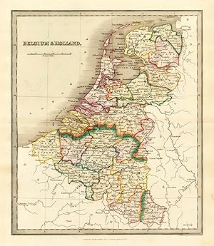
Belgium & Holland.
Verlag: Findlay Alex., London, 1843
Anbieter: Antiquariat Reinhold Berg eK Inh. R.Berg, Regensburg, Deutschland
Bewertung:
Karte
Other. Engraved map, hand colored in wash and outline, when published. Nice and detailed map of Belgium and Holland, with engraved place names, rivers and political borders. Drawn and engraved by Alexander Findley in London. In excellent condition. 218 by 253mm (8˝ by 10 inches). 218 by 253mm (8˝ by 10 inches).
-

Spain & Portugal
Verlag: Alexander Findlay, London, 1843
Anbieter: Antiquariat Reinhold Berg eK Inh. R.Berg, Regensburg, Deutschland
Bewertung:
Karte
Other. Steel engraving, hand colored in outline when published. Nice and detailed map of Spain & Portugal with engraved place names, rivers and political borders. Drawn and engraved by Alexander Findlay in London. In excellent condition. 213 by 263mm (8˝ by 10Ľ inches). 213 by 263mm (8˝ by 10Ľ inches).
-
Einführung in die Phasenlehre und ihre Anwendungen. Mit 134 Abb. im Text und einer Tafel.
Leipzig, Barth, 1907. Lex8vo. Cont. hcloth. VII,224 pp.
-
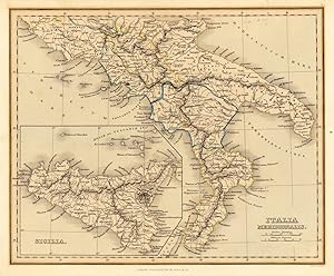
Italia Meridionalis.
Verlag: Alexander Findlay, London, 1843
Anbieter: Antiquariat Reinhold Berg eK Inh. R.Berg, Regensburg, Deutschland
Bewertung:
Karte
Other. Steel engraving, hand colored in outline when published. Nice and detailed map of southern Italy with engraved place names, rivers and political borders. Drawn and engraved by Alexander Findlay in London. In excellent condition. 215 by 264mm (8˝ by 10˝ inches). 215 by 264mm (8˝ by 10˝ inches).
-
Original fine print. Print area measures:23 cm x 17,5 cm. Karte. map. Published by Thomas Kelly, 17, Paternoster Row. Drawn and engraved by Alexander Findlay. Paper browned. Druckgrafik.
-
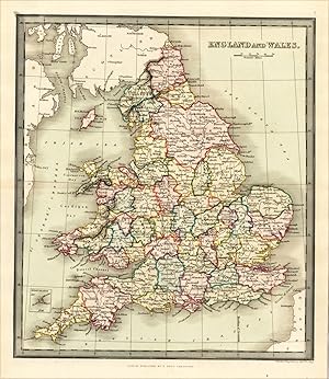
England and Wales
Verlag: Findlay Alex., London, 1843
Anbieter: Antiquariat Reinhold Berg eK Inh. R.Berg, Regensburg, Deutschland
Bewertung:
Karte
Other. Engraved map, hand colored in wash and outline, when published. Nice and detailed map of England and Wales with engraved place names, rivers and political borders. Drawn and engraved by Alexander Findley in London. In excellent condition. 220 by 255mm (8ľ by 10 inches). 220 by 255mm (8ľ by 10 inches).
-

4°, Broschiert. Original Landkarte "Italy" gest. v. Alex Findlay, hrsg. Thomas Kelly, London, 1842, Blattgröße ca. 27 x 20,5 cm guter-sehr guter Zustand. ohne nennenswerte Mängel Sprache: Deutsch Gewicht in Gramm: 750.
-
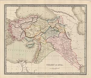
Turkey in Asia.
Verlag: Findlay Alex, London, 1843
Anbieter: Antiquariat Reinhold Berg eK Inh. R.Berg, Regensburg, Deutschland
Bewertung:
Karte
Other. Engraved map, hand colored in wash and outline, when published. Interesting map showing Turkey in Asia, with engraved place names, rivers and political borders. Drawn and engraved by Alexander Findlay in London. In excellent condition. 219 by 255mm (8˝ by 10 inches).
-
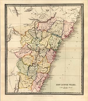
New South Wales.
Verlag: Findlay Alex, London, 1843
Anbieter: Antiquariat Reinhold Berg eK Inh. R.Berg, Regensburg, Deutschland
Bewertung:
Karte
Other. Engraved map, hand colored in wash and outline, when published. Interesting map showing New South Wales, with engraved place names, rivers and political borders. Drawn and engraved by Alexander Findlay in London. In excellent condition. 252 by 219mm (10 by 8˝ inches). 252 by 219mm (10 by 8˝ inches).
-

Arabia
Verlag: W. Tegg, London, 1847
Anbieter: Alexandre Antique Prints, Maps & Books, Toronto, ON, Kanada
Bewertung:

Karte
Zustand: Excellent. Size : 240x300 (mm), 9.5x11.75 (Inches), Hand Colored.
-
New South Wales
Verlag: Thomas Kelly c.1835, London, 1835
Anbieter: Alexandre Antique Prints, Maps & Books, Toronto, ON, Kanada
Bewertung:
Karte
Zustand: Very Good. Size : 245x295 (mm), 9.65x11.61 (Inches), Black & White.
-
Einf hrung in die Phasenlehre und ihre Anwendungen.
Verlag: Leipzig, Verlag von Johann Ambrosius Barth, 1907., 1907
HLDr mit Lederecken und gepr. Einband, 4ˇ, 224 S., mit 134 Abb. im Text und einer Tafel, Band VI. der Reihe: Handbuch der Angewandten Physikalischen Chemie". besch digtes Exlibris Erich Ebler" und zwei Stempel auf Schmutz- und Titelblatt "Prof. Dr. Erich Ebler, Heidelberg".
-
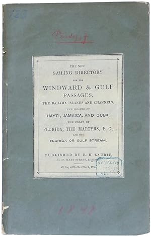
The Sailing Directory for the Windward and Gulf Passages, the Bahama Islands and Channels, the Islands of Hayti, Jamaica, and Cuba, the Coast of Florida, the Martyrs, etc., and the Florida or Gulf Stream. To Accompany the Chart . . . by John Purdy.
Verlag: London: Printed for Richard Holmes Laurie,, 1848
Anbieter: Meridian Rare Books ABA PBFA, London, Vereinigtes Königreich
Verbandsmitglied: ABA ILAB PBFA
Bewertung:

Buch
Soft cover. Zustand: Good. 4th Edition. Fourth edition, Revised and Corrected from Recent Authorities . 8vo. pp. vi, 160; a few illusts. or plans to text; minor age-toning, ex library of the Marinens Bibliotek (Copenhagen) with inkstamp to title-page, else very good in contemporary (?original) wrappers with paper label to upper wrapper (titled The New Sailing Directory ), worn to extremities, old inkstamp to label. An uncommon sailing directory for the West Indies. Though issued for use with the chart mentioned in the title, most such directories were sold separately from the charts to which they relate, and in many instances both directories and charts are hard to find. This volume previously formed part of the holdings of the Danish Marinens Bibliotek, the centre for Naval and maritime research in Copenhagen.
-
Memoir, descriptive and explanatory, to accompany the Charts of the Northern Atlantic Ocean and comprising Instructions, general and particular, for the Navigation of that Sea. Tenth Edition corrected and materially improved, from many original Comm.
London, R.H. Laurie, 1853. Orig. boards, later clothbacked. With orig. printed titlelabel pasted on frontboard. Stamps on title-page. Covers with traces of use. XIV,582 pp. + (6) pp. of printers catalogue of Charts. One folded engraved map (Coursed of various Hurricanes), textillustrations (lighthouses, coastal profiles etc.). A few scattered brownspots.
-
The British American Navigator. A sailing Directory for the Islands and Banks of New Foundland, the Gulf and River of St. Lawrence, Breton Island, Nova Scotia, the Bay of Fundy and the Coasts thence to the River Penobscot, etc. originally composed by .
London, R.H. Laurie, 1847. Contemp. boards, later clothbacked and with the printed part of the original frontwrapper pasted on upper board. Stamps on title-page. XXVI,202 pp. Some even browning to the first leaves, otherwise fine. Sabin, 66691.
-
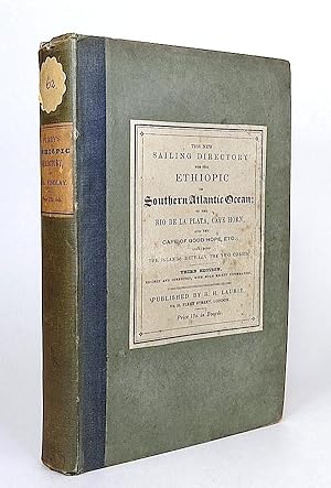
The New Sailing Directory for the Ethiopic or Southern Atlantic Ocean; including the Coasts of Brasil, etc., to the Rio de la Plata, the Coast thence to Cape Horn, and the African Coast to the Cape of Good Hope, etc.; including the Islands between the Two Coasts. Third Edition, Revised and Corrected.
Verlag: London, R. H. Laurie, 1845
Buch
Hardcover. Zustand: . ~ [TEMPORARY REDUCTION SALE: 20-30% OFF THE REGULAR PRICE] ~ (illustrator). Octavo. Pp. xlviii, 472. Engraved text figures. HARDCOVER, bound in contemporary quarter cloth and matching boards, original lettring-pieces mounted on cover and spine with a floral-shape shelf label; wear to spine head, old institutional stamp to first free endpaper, and another, almost invisible, to title-page. In a very good condition. ~ Third edition, revised and corrected by Alex G. Findlay. First published in 1837, the work went through several editions. I-1.
-
The Brasilian navigator; or, Sailing directory for all the coasts of Brasil, etc., from the River Para to the Rio de la Plata, including general instructions for the routes both from England and from North America, with descriptions of, and directions for, the Madeira, Canary, and Cape Verde Islands, Fernando Noronha, etc. [.]. By John Purdy. 4th edition. Improved from the obercations of MM. Tardy de Montravel, [etc.], By Alex G. Findlay.
Anbieter: Antiquariaat A. Kok & Zn. B.V., Amsterdam, Niederlande
Bewertung:
Lodnon, Richard Holmes Laurie 1854. XII,224 pp. Contemp. wrappers. 8vo. - Spine damaged; backcover & last pages stained. - With (cancelled) bookplate of the Scheepvaartmuseum Amsterdam. Extremely rare fourth edition of this sailing guide for the Brazilian coast (only one copy of the 4th edition registered in Worldcat). Of the of various editions issued between 1838 and 1862 only 12 copies are listed on OCLC. This work was issued to accompany Laurie's new general chart of the coasts, entitled 'General chart of the coasts of Brasil, &c., from the River Para to Buenos Ayres; with particular plans of the harbours.'.