
Gesamtpreis (1 Artikel Artikel):
Versandziel:

freycinet louis claude charles pierre boullanger (2 Ergebnisse)
Direkt zu den wichtigsten Suchergebnissen
Produktart
- Alle Produktarten
- Bücher (1)
- Magazine & Zeitschriften
- Comics
- Noten
- Kunst, Grafik & Poster
- Fotografien
- Karten (1)
-
Manuskripte &
Papierantiquitäten
Zustand
- Alle
- Neu
- Antiquarisch/Gebraucht
Einband
- alle Einbände
- Hardcover
- Softcover
Weitere Eigenschaften
- Erstausgabe
- Signiert
- Schutzumschlag
- Angebotsfoto
Land des Verkäufers
Verkäuferbewertung
-

Carte d'une partie de la Terre de Witt (a la Nouvelle-Hollande), Dressee par M. L. Freycinet, Commandant le Casuarina & Boullanger, Ingenieur-Hydrographe d'apres leurs observations et celles de Mr. Ronsard, annees 1801 & 1803 (Western Australian coast)
Verlag: l'Imprimerie Imperiale, Paris, 1812
Anbieter: Muir Books -Robert Muir Old & Rare Books - ANZAAB/ILAB, PERTH, WA, Australien
Bewertung:

Original copper engraving, 740mm x 490mm, centre fold. Plate 26, (2me Feuille) Chart of part of Witt's Land along the north-west coast of Western Australia showing the area explored by Freycinet from Bancs des Planaires (near Port Hedland) to Cape Leveque (Dampier Peninsula, north of Broome) and showing the tracks of Le Geographe in 1801 and Le Casuarina in 1803. Three insets : Coupang Bay in Timor, the town of Coupang and a detail of Terre de Witt from Cape Jaubert to Cape Bossut. Tooley 649. Near fine condition. Detailed chart produced on the official French voyage to survey and explore Australia and the Pacific. Commanded by Nicolas Baudin, the expedition left France in 1800 with Francois Peron on board as naturalist, Louis Freycinet as cartographer, and Charles-Pierre Boullanger as geographer. The two ships on the voyage 'Le Geographe' and 'Le Naturaliste' arrived at Cape Leeuwin in 1801. Details of the coastline were documented as the ships sailed north. After crossing Timor the ships moved south to survey Tasmania.
-
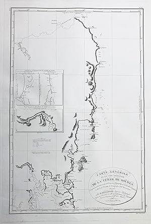
Carte Generale de la Cote Orientale de la Terre de Diemen" - Australia Tasmania / Tasmanien Australien
Verlag: Paris, 1802
Anbieter: Antiquariat Steffen Völkel GmbH, Seubersdorf, Deutschland
Bewertung:
Karte
Großformatige Kupferstich-Karte aus dem 19. Jh. -- Bildmasse: ca. 76 x 50 cm. -- gut erhalten. || Large copper engraved map from the 19th century. -- in very good condition. Sprache: Französisch Gewicht in Gramm: 35.