
Gesamtpreis (1 Artikel Artikel):
Versandziel:

johnson ward (76 Ergebnisse)
Direkt zu den wichtigsten Suchergebnissen
Produktart
- Alle Produktarten
- Bücher (63)
- Magazine & Zeitschriften (1)
- Comics
- Noten
- Kunst, Grafik & Poster
- Fotografien
- Karten (11)
-
Manuskripte &
Papierantiquitäten (1)
Zustand
Einband
Weitere Eigenschaften
Land des Verkäufers
Verkäuferbewertung
-
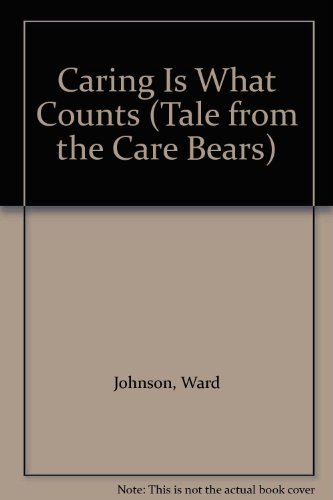
Caring Is What Counts
Verlag: Scholastic Library Publishing, 1985
ISBN 10: 0516090011ISBN 13: 9780516090016
Buch
Zustand: Good. Used book that is in clean, average condition without any missing pages.
-
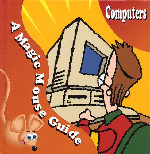
Computers : A Magic Mouse Guide
Verlag: Enslow Publishing, LLC, 2002
ISBN 10: 0766022633ISBN 13: 9780766022638
Buch
Zustand: Very Good. Laughing Gravy Design (illustrator). Used book that is in excellent condition. May show signs of wear or have minor defects.
-
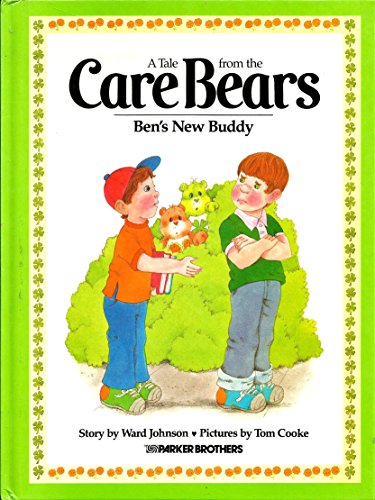
Ben's New Buddy (Tale from the Care Bears)
Verlag: Parker Brothers, 1984
ISBN 10: 0910313164ISBN 13: 9780910313162
Anbieter: Wonder Book, Frederick, MD, USA
Bewertung:

Buch
Zustand: Good. Cooke, Tom (illustrator). Good condition. A copy that has been read but remains intact. May contain markings such as bookplates, stamps, limited notes and highlighting, or a few light stains.
Mehr Angebote von anderen Verkäufern bei ZVAB
Gebraucht ab EUR 5,44
-
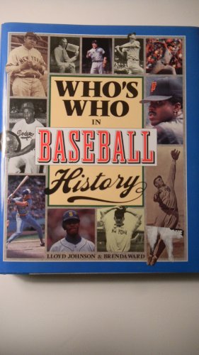
Who's Who in Baseball History
Verlag: Barnes & Noble Books, 1994
ISBN 10: 1566194695ISBN 13: 9781566194693
Buch Erstausgabe
Zustand: Good. 1st. Used book that is in clean, average condition without any missing pages.
-

Caring Is What Counts
Verlag: Parker Brothers Publishing, 1983
ISBN 10: 0910313059ISBN 13: 9780910313056
Buch Erstausgabe
Zustand: Good. Cooke, Tom (illustrator). First Edition. Used book that is in clean, average condition without any missing pages.
-

CIG: Troubleshooting your PC (Complete Idiot''s Guides)
Verlag: Pearson Education Ltd, 2002
ISBN 10: 0130456322ISBN 13: 9780130456328
Buch
Paperback. Zustand: Very Good. The book has been read, but is in excellent condition. Pages are intact and not marred by notes or highlighting. The spine remains undamaged.
Mehr Angebote von anderen Verkäufern bei ZVAB
Gebraucht ab EUR 1,27
-
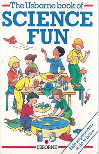
Science Fun
Verlag: Edc Pub, 1992
ISBN 10: 0746003617ISBN 13: 9780746003619
Anbieter: Wonder Book, Frederick, MD, USA
Bewertung:
Buch
Zustand: Very Good. Very Good condition. A copy that may have a few cosmetic defects. May also contain light spine creasing or a few markings such as an owner's name, short gifter's inscription or light stamp. Bundled media such as CDs, DVDs, floppy disks or access codes may not be included.
-

The World Wide Web (Magic mouse)
Verlag: Cherrytree Books
ISBN 10: 1842340778ISBN 13: 9781842340776
Buch
Hardback. Zustand: Very Good. The book has been read, but is in excellent condition. Pages are intact and not marred by notes or highlighting. The spine remains undamaged.
-
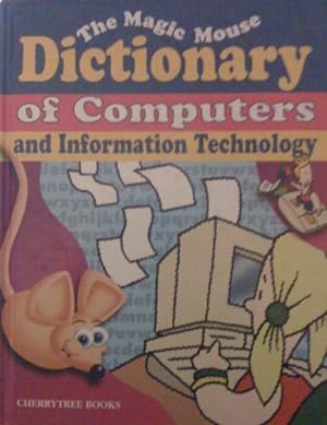
The Magic Mouse Dictionary of Computers and Information Technology
Verlag: Cherrytree Books, 2001
ISBN 10: 1842340565ISBN 13: 9781842340561
Buch
Zustand: VeryGood. Most items will be dispatched the same or the next working day.
-
Caring Is What Counts, No. 5 (Tale from the Care Bears)
Verlag: Parker Brothers, 1983
ISBN 10: 0910313059ISBN 13: 9780910313056
Anbieter: Wonder Book, Frederick, MD, USA
Bewertung:
Buch Erstausgabe
Zustand: Good. Cooke, Tom (illustrator). First edition copy. . Owner's name on page 2.
-

Spaß mit Experimenten
Verlag: Ravensburger Buchverlag G, 1986
ISBN 10: 3473355410ISBN 13: 9783473355419
Anbieter: Versandantiquariat Felix Mücke, Grasellenbach - Hammelbach, Deutschland
Bewertung:
Buch
Gebundene Ausgabe. Zustand: Akzeptabel. 192 Seiten Artikel stammt aus Nichtraucherhaushalt! T15333 Sprache: Deutsch Gewicht in Gramm: 358.
Mehr Angebote von anderen Verkäufern bei ZVAB
Gebraucht ab EUR 2,37
-

5. Aufl. 192 S 18,8x12,2cm, illustr. Hardcover, zahlr. Abbildungen im Text, gutes exemplar.
-
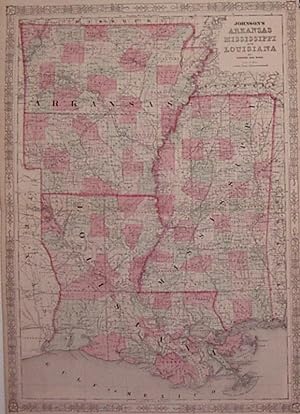
Johnson's Arkansas Mississippi and Louisiana
Verlag: Johnson & Ward, New York, 1863
Anbieter: Argosy Book Store, ABAA, ILAB, New York, NY, USA
Bewertung:
unbound. Zustand: near fine. Map. Steel engraving with original hand coloring. Image measures 24.25" x 17.25". Classic map of Arkansas, Mississippi and Louisiana divided into counties and townships. Shows all major towns, cities, routes, waterways and railroads. Alvin Jewett Johnson (1827-1884) is one of the most prolific American publishers of the 19th century. He opened his own company in 1856 that produced atlases, maps and encyclopedias. The company made great maps based on those by J.H. Colton and Johnson produced a newly updated version every year up until the late 19th century.
-

Jane Eyre
Verlag: Pearson Education 2008-03-11, Harlow, 2008
ISBN 10: 1405876638ISBN 13: 9781405876636
Buch
paperback. Zustand: New. Language: ENG.
-
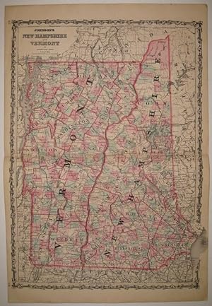
Johnson's New Hampshire and Vermont
Verlag: Johnson & Ward, New York, 1862
Anbieter: Argosy Book Store, ABAA, ILAB, New York, NY, USA
Bewertung:
unbound. Zustand: very good(+). Map. Engraving with original hand coloring. Image measures 24" x 17.5". Bold double page map of New Hampshire and Vermont divided into counties and townships. Delineates towns, waterways, railroads and major routes. In excellent condition with light creasing to upper left and light scattered foxing to margins. Alvin Jewett Johnson (1827-1884) is one of the most prolific American publishers of the 19th century. He opened his own company in 1856 that produced atlases, maps and encyclopedias. The company made great maps based on those by J.H. Colton and Johnson produced a newly updated version every year up until the late 19th century.
-
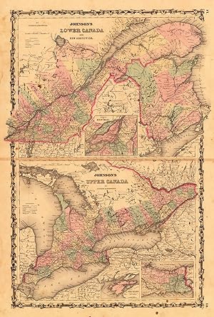
Johnson's Lower Canada and New Brunswick - Johnson's Upper Canada by Johnson and Ward.
Verlag: Johnson & Ward, New York, 1865
Anbieter: Antiquariat Reinhold Berg eK Inh. R.Berg, Regensburg, Deutschland
Bewertung:

Karte
Other. Lithograph, original colored in outline and wash. In very good condition. On the sheet some brown spots slightly visible. 610 by 396mm (24 by 15˝ inches). 610 by 396mm (24 by 15˝ inches).
-
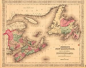
Johnson s New Brunswick, Nova Scotia, Newfoundland and Prince Edward P. by Johnson and Ward.
Verlag: Johnson & Ward, New York, 1865
Anbieter: Antiquariat Reinhold Berg eK Inh. R.Berg, Regensburg, Deutschland
Bewertung:
Karte
Other. Lithograph, original colored in outline and wash. This beautiful decorative antique map shows the Island Newfoundland, Nova Scotia, Islands of Anticosti and New Brunswick. On the sheet the upper margin is a bit narrow and a brown spot is visible else in very good condition. 320 by 400mm (12˝ by 15ľ inches). 320 by 400mm (12˝ by 15ľ inches).
-
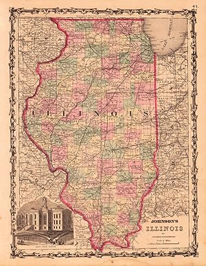
Johnson s Illinois by Johnson & Browning.
Verlag: New York, 1868
Anbieter: Antiquariat Reinhold Berg eK Inh. R.Berg, Regensburg, Deutschland
Bewertung:
Karte
Other. Lithograph, original color in outline and wash. Detailed map which shows Illinois. The map is equipped with many towns, place names, rivers, etc. In the lower left corner we find a print of the Court-House in Chicago. In very good condition. 420 by 314mm (16˝ by 12Ľ inches). 420 by 314mm (16˝ by 12Ľ inches).
-

Johnson s New York by Johnson and Ward.
Verlag: Johnson & Ward, New York, 1865
Anbieter: Antiquariat Reinhold Berg eK Inh. R.Berg, Regensburg, Deutschland
Bewertung:
Karte
Other. Lithograph, original color in outline and wash. In very good condition. On the back side some repairs visible. 428 by 635mm (16ľ by 25 inches). 428 by 635mm (16ľ by 25 inches).
-
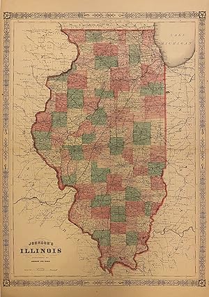
Johnson's Illinois
Verlag: Johnson & Ward, New York, 1865
Anbieter: Argosy Book Store, ABAA, ILAB, New York, NY, USA
Bewertung:
unbound. Map. Engraving with original hand coloring. Image measures 23.25" x 17.25". Nicely detailed map of Illinois divided into counties showing towns, waterways and railroads. Minor scattered foxing. Alvin Jewett Johnson (1827-1884) is one of the most prolific American publishers of the 19th century. He opened his own company in 1856 that produced atlases, maps and encyclopedias. The company made great maps based on those by J.H. Colton and Johnson produced a newly updated version every year up until the late 19th century.
-
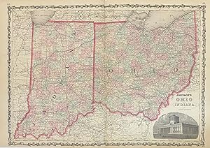
Johnson's Ohio and Indiana
Verlag: Johnson & Browning, New York, 1862
Anbieter: Argosy Book Store, ABAA, ILAB, New York, NY, USA
Bewertung:
unbound. Map. Engraving with original hand coloring. Image measures 17" x 24". Beautifully detailed double page map of Ohio and Indiana divided into counties and townships. Shows towns, major routes, waterways and railroads. Includes image of the state capitol building in Columbus. In excellent condition. Alvin Jewett Johnson (1827-1884) is one of the most prolific American publishers of the 19th century. He opened his own company in 1856 that produced atlases, maps and encyclopedias. The company made great maps based on those by J.H. Colton and Johnson produced a newly updated version every year up until the late 19th century.
-
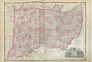
Johnson's Ohio and Indiana
Verlag: Johnson & Ward, New York, 1863
Anbieter: Argosy Book Store, ABAA, ILAB, New York, NY, USA
Bewertung:
unbound. Map. Engraving with original hand coloring. Image measures 17" x 24". Beautifully detailed double page map of Ohio and Indiana divided into counties and townships. Shows towns, major routes, waterways and railroads. Includes image of the state capitol building in Columbus. In excellent condition. Alvin Jewett Johnson (1827-1884) is one of the most prolific American publishers of the 19th century. He opened his own company in 1856 that produced atlases, maps and encyclopedias. The company made great maps based on those by J.H. Colton and Johnson produced a newly updated version every year up until the late 19th century.
-
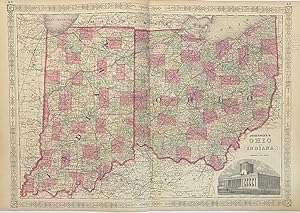
Johnson's Ohio and Indiana
Verlag: Johnson & Ward, New York, 1864
Anbieter: Argosy Book Store, ABAA, ILAB, New York, NY, USA
Bewertung:
unbound. Map. Engraving with original hand coloring. Image measures 17" x 24". Beautifully detailed double page map of Ohio and Indiana divided into counties and townships. Shows towns, major routes, waterways and railroads. Includes image of the state capitol building in Columbus. In very good condition. Pencil notations in right margin. Alvin Jewett Johnson (1827-1884) is one of the most prolific American publishers of the 19th century. He opened his own company in 1856 that produced atlases, maps and encyclopedias. The company made great maps based on those by J.H. Colton and Johnson produced a newly updated version every year up until the late 19th century.
-
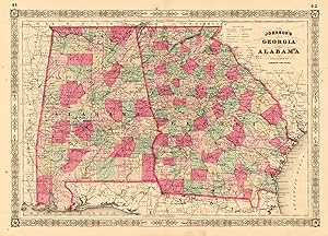
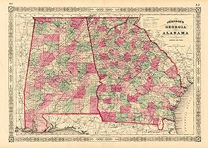
Johnson s Georgia and Alabama
Verlag: New York, 1863
Anbieter: Antiquariat Reinhold Berg eK Inh. R.Berg, Regensburg, Deutschland
Bewertung:
Karte
Other. Lithograph, original hand colored in outline and wash. This antique map shows the southern states Georgia and Alabama. Inside the map are many place names, rivers, etc. Detailed map of Georgia and Alabama, the two southern states divided up into counties in fine hand color. In very good to excellent condition. Two minor brown spots, one within the image of the map. 395 by 560mm (15˝ by 22 inches). 395 by 560mm (15˝ by 22 inches).
-
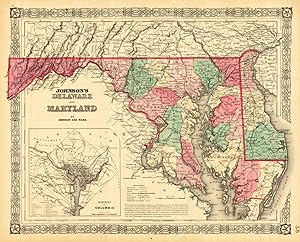
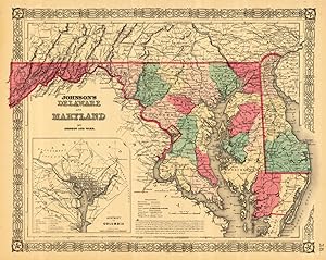
Johnson s Delaware and Maryland by Johnson and Ward.
Verlag: Johnson & Ward, New York, 1865
Anbieter: Antiquariat Reinhold Berg eK Inh. R.Berg, Regensburg, Deutschland
Bewertung:
Karte
Other. Lithograph, original color in outline and wash. This very detailed antique map shows the states Maryland, Delaware and Pennsylvania. The cartouche and an inset map of the district of Columbia is in the lower left corner. Some explanations and a mileage scale are on the left of the inset map. In excellent condition. 323 by 405mm (12ľ by 16 inches). 323 by 405mm (12ľ by 16 inches).
-
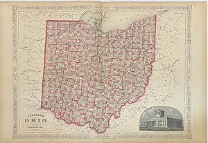
Johnson's Ohio
Verlag: Johnson & Ward, New York, 1867
Anbieter: Argosy Book Store, ABAA, ILAB, New York, NY, USA
Bewertung:
unbound. Map. Engraving with original hand coloring. Image measures 17" x 24". Beautifully detailed double page map of Ohio and Indiana divided into counties and townships. Shows towns, major routes, waterways and railroads. Includes image of the state capitol building in Columbus. In excellent condition. Alvin Jewett Johnson (1827-1884) is one of the most prolific American publishers of the 19th century. He opened his own company in 1856 that produced atlases, maps and encyclopedias. The company made great maps based on those by J.H. Colton and Johnson produced a newly updated version every year up until the late 19th century.
-
JOHNSON'S JAPAN, NIPPON, KIUSIU, SIKOK, YESSO AND THE JAPANESE KURILES.
Anbieter: RARE ORIENTAL BOOK CO., ABAA, ILAB, Aptos, CA, USA
Bewertung:
New York 1855, Johnson. A single sheet map, very good, 18 x 14.25 inches, colored, with inset of Nagasaki & Yesso. A few margin chips, suitable for framing, matted. S C A R C E.
-
Delaware and Maryland
Verlag: Johnson & Ward, New York, 1862
Anbieter: Antiquariat Reinhold Berg eK Inh. R.Berg, Regensburg, Deutschland
Bewertung:
Karte
Other. Original antique lithograph, colored in outline and wash when published. This very detailed antique map shows the states Maryland, Delaware and Pennsylvania. The cartouche and an inset map of the district of Columbia is in the lower left corner. Some explanations and a mileage scale are on the left of the inset map. In very good condition. 400 by 320mm (15ľ by 12˝ inches). 400 by 320mm (15ľ by 12˝ inches).
-
Johnson s Georgia and Alabama published by Johnson and Ward.
Verlag: Johnson & Ward, New York, 1865
Anbieter: Antiquariat Reinhold Berg eK Inh. R.Berg, Regensburg, Deutschland
Bewertung:
Karte
Other. Lithograph, original color in outline and wash. In very good condition. 394 by 562mm (15˝ by 22Ľ inches). 394 by 562mm (15˝ by 22Ľ inches).
-
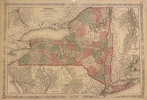
Johnson's New York
Verlag: Johnson & Ward, New York, 1864
Anbieter: Argosy Book Store, ABAA, ILAB, New York, NY, USA
Bewertung:
unbound. Zustand: very good. Map. Engraving with original hand coloring. Image measures 16.75" x 24.75". Beautifully detailed double page map of New York state divided into counties and townships. Shows towns, waterways, railroads and topographical features. Includes insets of Oswego, Albany, Troy, Buffalo, Rochester, Syracuse and "vicinity of New York". In very good condition. Minor stair and foxing to lower margin, not affecting the image. Alvin Jewett Johnson (1827-1884) is one of the most prolific American publishers of the 19th century. He opened his own company in 1856 that produced atlases, maps and encyclopedias. The company made great maps based on those by J.H. Colton and Johnson produced a newly updated version every year up until the late 19th century.
