
Gesamtpreis (1 Artikel Artikel):
Versandziel:

laurie richard holmes james whittle (3 Ergebnisse)
Direkt zu den wichtigsten Suchergebnissen
Produktart
- Alle Produktarten
- B¸cher (2)
- Magazine & Zeitschriften
- Comics
- Noten
- Kunst, Grafik & Poster
- Fotografien
- Karten (1)
-
Manuskripte &
Papierantiquit‰ten
Zustand
- Alle
- Neu
- Antiquarisch/Gebraucht
Einband
- alle Einb‰nde
- Hardcover (2)
- Softcover
Weitere Eigenschaften
- Erstausgabe (1)
- Signiert
- Schutzumschlag
- Angebotsfoto (1)
Land des Verk‰ufers
Verk‰uferbewertung
-
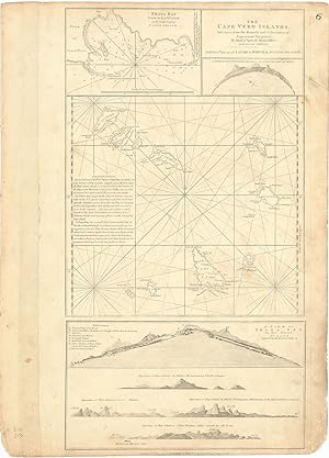
The Cape Verd Islands, laid down from the Remarks and Observations of Experienced Navigators, by Monsr. d'Apres de Mannevillete, with several Additions.
Verlag: LondonLaurie & Whittle 12th May ., 1794
Anbieter: Robert Frew Ltd. ABA ILAB, London, Vereinigtes Kˆnigreich
Verbandsmitglied: ABA ILAB PBFA
Bewertung:

Karte
Original uncoloured engraved map of the Cape Verde islands. Map dimensions 52 x 28.5 cm, overall sheet dimensions 54 x 38.5 cm. A bit toned overall and with some smudging to marings. A finely detailed chart of the Cape Verde Islands off the Coast of Africa, which appeared in a later edition of the West India Atlas. This sheet of sea charts details the Cape Verde Islands. First settled by the Portuguese in 1462, it soon became a popular haunt for pirates, including Sir Francis Drake in the 1580s. The sheet features with inset maps of Praya Bay, A View of the English Road, A View of Praya Bay and a group of recognition views. Sayer and Bennet based their work on charts by Jean-Baptiste Mannevillettes's Le Neptune Oriental (Paris, 1745).
-

Laurie and Whittle's piloting directions for the eastern coasts of Britain, from Flamborough Head to Buchanness including the Frith of Forth, and other harbours.
Erstausgabe
London : Printed for Robert Laurie and James Whittle, 1810. 4to (210 x 135 mm). In later half cloth with title in gilt lettering to front board. Three stamps to title-page and paper with light creasing throughout, otherwise fine. (4), 30, (2) pp. Rare first (only?) edition of this pilot.OCLC only locates two copies (British Library, National Library of Scotland).
-
New Sailing Directions to accompany the Channel Pilot and their large general chart of the English Channel, [.]. Fifth Edition.
London, printed for James Whittle and Richard Holmes Laurie, 1815. 8vo. In contemporary blue boards (original ?). Stamp to spine. Stamp and annotations in contemporary hand to title-page. Soiling and wear to extremities and brownspottet throughout. VIII, 130 pp. + folded tabel on the tides in English channel. Rare fifth edition of Whittle and Laurie's pilot to the English Channel.
