Gesamtpreis (1 Artikel Artikel):
Versandziel:

maitland william 1693 1757 (2 Ergebnisse)
Direkt zu den wichtigsten Suchergebnissen
Produktart
- Alle Produktarten
- Bücher (1)
- Magazine & Zeitschriften
- Comics
- Noten
- Kunst, Grafik & Poster
- Fotografien
- Karten (1)
-
Manuskripte &
Papierantiquitäten
Zustand
- Alle
- Neu
- Antiquarisch/Gebraucht
Einband
- alle Einbände
- Hardcover
- Softcover
Weitere Eigenschaften
- Erstausgabe (1)
- Signiert
- Schutzumschlag
- Angebotsfoto
Land des Verkäufers
Verkäuferbewertung
-
The History of London from Its Foundation by the Romans to the Present Time. Containing a Faithful Relation of the Publick Transactions of the Citizens; Accounts of the Several Parishes; Parallels between London and Other Great Cities; Its Governments Civil Ecclesiastical and Military; Commerce State of Learning Charitable Foundations &c. With the Several Accounts of Southwark and Other Parts within the Bill of Mortality. In Nine Books with An Account of the Number of Persons Dying at the Several Ages Undermentioned for Ten Years Past
Verlag: Samuel Richardson, in Salisbury Court near Fleet Street, London, 1739
Anbieter: James Cummins Bookseller, ABAA, New York, NY, USA
Bewertung:

Erstausgabe
First edition. First edition. Folding frontispiece and 24 plates (3 folding) viii, [5, Subscribers], [1], [1]-800, [14, index] pp. 1 vols. Folio (15-1/2 x10 inches). Later brown half morocco, t.e.g. Some rubbing to binding, frontispiece backed at top, some creasing Folding frontispiece and 24 plates (3 folding) viii, [5, Subscribers], [1], [1]-800, [14, index] pp. 1 vols. Folio (15-1/2 x10 inches).
-
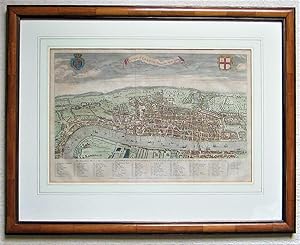
A View of London about the Year 1560. Reduced to this Size from a Large Print in the collection of Sir Hans Sloane Bart. 1738.
Verlag: London, 1738
Anbieter: Angelika C. J. Friebe Ltd. - MapWoman, Dorking, Vereinigtes Königreich
Bewertung:
Karte
No Binding. Zustand: Very Good. An iconic plan of London at the time of Elizabeth I. copper engraved map with old hand colouring. wooden frame 55 x 70 cm. some wear and tear, o/w vg cond. platesize 31 x 47 cm. folds as issued; some slight browning; o/w vg cond. This map of London was published as frontispice to Volume I of William Maitland s History of London . As quoted on the map, this is a derivative of a larger map in the collection of Sir Hans Sloane, to be believed from a woodcut map attributed to Ralph Agas, and copied for the Society of Antiquaries in 1737. The map gives a marvellous impression of Elizabethan London, with a key identifying 80 streets and places of interest. The title is in a banner-like cartouche, surrounded with coat-of-arms of the City of London and the Royal crest. Howgego 8b However, some details in the map, such as the delineation of Lambeth Palace, are reminiscent of the so-called Copperplate Map : the oldest printed map of the city of which no complete copy has survived , and on which both the Agas view and the Braun & Hogenberg s 1724 map were based.