Gesamtpreis (1 Artikel Artikel):
Versandziel:

mortier pierre (272 Ergebnisse)
Direkt zu den wichtigsten Suchergebnissen
Produktart
- Alle Produktarten
- Bücher (93)
- Magazine & Zeitschriften
- Comics
- Noten
- Kunst, Grafik & Poster (92)
- Fotografien
- Karten (87)
-
Manuskripte &
Papierantiquitäten
Zustand
Einband
Weitere Eigenschaften
Land des Verkäufers
Verkäuferbewertung
-
Paris,Chez Ronald Davis 1927. In-8 carré broché de 29 pages non coupées. Tiragel imité ŕ 500 exemplaires. Bon état. Livres.
-
Benjamin Constant; 46e année, N° 467, mai 1968.
Verlag: Paris, Europe et les Editeurs français réunis
Anbieter: JLG_livres anciens et modernes, Saint Maur des Fossés, Frankreich
Verbandsmitglied: ILAB
Bewertung:

Buch
Zustand: Trčs bon. Le centenaire d'André Spire. Nos envois se font avec suivi, pour tout problčme n'hésitez pas ŕ nous contacter pour trouver une solution.
-
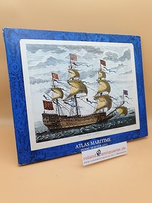
Atlas Maritime - Pierre Mortier 1693 (komplett: mit 12 Tafeln)
Verlag: Wuppertal, Dr. Wolfgang Schwarze Verlag o. J.
Anbieter: Roland Antiquariat UG haftungsbeschränkt, Weinheim, Deutschland
Bewertung:

Kunst / Grafik / Poster
Mappe mit Umschlag. Mappe mit Umschlag und 12 Tafeln Mappe mit Umschlag und 12 Tafeln - Sehr guter Zustand. Altersfreigabe FSK ab 0 Jahre Sprache: Deutsch Gewicht in Gramm: 2500.
-

atlas maritime. 11 lose tafeln ( plus einer unterlagstafel ) in mappe. eine faksimile von 1693.
Verlag: dr. wolfgang schwarz verlag, wuppertal
Anbieter: alt-saarbrücker antiquariat g.w.melling, Saarbrücken, Deutschland
Bewertung:
Erstausgabe
Paperback. Zustand: Sehr gut. 1. auflage. quer-oktav paperback. gutes bis sehr gutes exemlar. 11 zum teil einfarbig-illustrierten tafeln in blauer farbig-illustrierter mappe ecken bestoßen und berieben, tafeln noch sehr gut erhalten. einband von ca. 1990. format 43 x 34,5 cm. 620 Gramm.
-
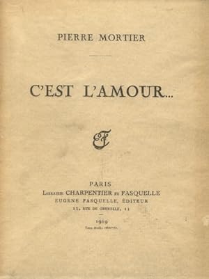
Paris, Librairie Charpentier et Fasquelle, 1919, in-16, br., pp. 202, (8). Graziosa edizione su carta vergata. Ex libris A. Manzini.
-
Couverture souple. Zustand: bon. R160130626: 1919. In-12. Broché. Bon état, Couv. convenable, Dos plié, Intérieur acceptable. 203 pages. Couverture contre pliée. . . . Classification Dewey : 841-Poésie.
-
Zustand: New.
-
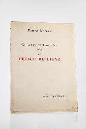
Conversation familičre avec le Prince de ligne
Verlag: Fasquelle, 1953
Buch Erstausgabe
couverture souple. - Fasquelle, Paris 1953, 14,5x19,5cm, broché. - Edition originale de ce discours prononcé ŕ Bruxelles ŕ l'occasion du deuxičme centenaire de la naissance du Prince de Ligne, un des 15 exemplaires numérotés sur Hollande, seuls grands papiers. Trois petites mouillures en pied du premier plat et en tęte du second, que:ques petites rousseurs intérieures. [ENGLISH DESCRIPTION ON DEMAND].
-
Senigallia 1724, um ca. Ľ vergrösserter Nachdruck aus dem 19. Jahrhundert
Verlag: Amsderdam, ohne Jahr
Guter Zustand, Blattmasse: 69 x 52 cm 1 Seite Sprache: Französisch.
-
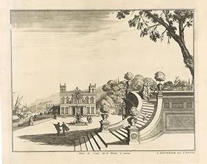
Palais de Livorne au bord de la Mer
Verlag: Livorno2
Anbieter: Sergio Trippini, Gavirate, Italien
Bewertung:
-
Palais du Grand Duc de Florence a Livorne
Verlag: Livorno2
Anbieter: Sergio Trippini, Gavirate, Italien
Bewertung:
-
Stampa antica ed originale con veduta dei resti del tempio.
-
Stampa antica ed originale con veduta del paese, e della cascata.
-
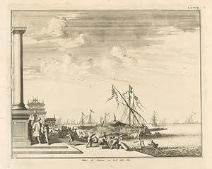
L'Isle d'Ischia dans le voisinage de Naples. Kupferstichkarte. Amsterdam (ca. 1700). Kartenblatt 39 x 50 cm. Mit vergoldetem Holzrahmen (56 x 66 cm) unter Glas mit Passepartout. Die Karte ist leicht gebräunt, mit leichter Knickfalte in der Mitte, insgesamt gut erhalten.- Mit detaillierten Darstellungen der wichtigsten Bauwerke wie Festungen, Türme und Städten, sowie verschiedenen Schiffen.
-
Enfants d Israel Dans le Desert depuis leur sortie d Egypte
Verlag: Mortier, Pierre
Anbieter: Apple Boutique, Drawings, Prints & Books, Geneva, Schweiz
Bewertung:
Kunst / Grafik / Poster
No Binding. Zustand: Very Good. Voyages des Enfants d Israel Dans le Desert depuis leur sortie d Egypte Par le Mare Rouges Iusques au Pays de Canaan. By: Pieter Mortier Date: 1725 (Published) Amsterdam Dimensions: 16.1 x 18.9 inches (488 mm x 417 mm) This elegant map illustrates the flight of the Children of Israel from Egypt to the Promised Land including their wanderings in the desert of what is now Arabia. We see the group congregated, ready to leave from Remeses in the land of Goshen. From there they moved in a southerly direction toward the Red Sea, camping at Etham, described as being at the edge of the wilderness. From Etham they made their way to Pihachiroth. It was from this encampment that they crossed the Red Sea. Once across the sea, the route of their wanderings and their numerous encampments are drawn, some in fine detail. At the center of the map is a prominent Mount Sinai, with the Jordan River and the Dead Sea in the upper left quadrant. The lower right quadrant features a graphic depiction of the closing of the Dead Sea over the pursuing Egyptians, with the Israelites safe on the opposite shore, looking down on the gruesome spectacle as soldiers, Pharaoh and all his charioteers drown when the waters close over them. Embellishing the upper right quadrant is a detailed figural title cartouche featuring the Israelites sowing and harvesting, as they must have done during the long years of their wandering. Covens & Mortier (1721-1866) were publishers of maps of the eighteenth century. The company was founded by Johannes Covens I (1697-1774) and Cornelis Mortier (1699-1783), located in Amsterdam. Condition: This map is in A condition. Minor foxing with even toning. Condition: This map is in good condition, mounted on a sheet of paper, some wear on the upper margin.
-
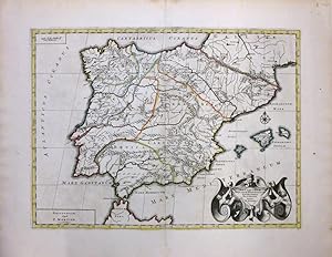
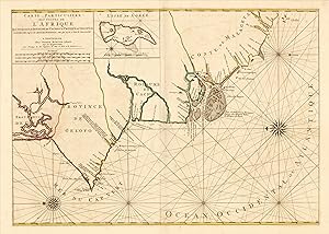
Antiquorum Hispaniae Episcopatuum Geographica Descriptio
Verlag: Pierre Mortier, Amsterdam, 1705
Anbieter: Argosy Book Store, ABAA, ILAB, New York, NY, USA
Bewertung:
unbound. Zustand: very good. Map. Copper plate engraving with original hand coloring. Image measures 14.5 x 19.5". Beautiful map of the Iberian Peninsula with several place names and topography noted. Includes the Balearic Islands of Majorca, Minorca and Ibiza. Territories shown with outline color. Map is on good condition with minor wear along centerfold and some offsetting. Minor spotting. Margins shows toning along edges and some spotting. Based on the earlier plates by Nicolas Sanson (1600 - 1667), who is considered the founder of the French school of cartography. In reaction to the prevailing trend of Dutch lavishness, Sanson favored minimal details, focusing rather on accurate cartography than ornament. Pierre Mortier (1661-1711) was a Dutch cartographer, engraver, and printseller who worked in Amsterdam. He used advanced Dutch printing methods to produce high quality editions of contemporary French maps by cartographers such as De L'Isle, Sanson, Jaillot, de Fer and De Wit. His greatest feat was the nautical atlas "Le Neptune Francois." This map is a resplendent example of his work.
-
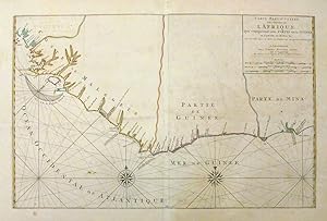
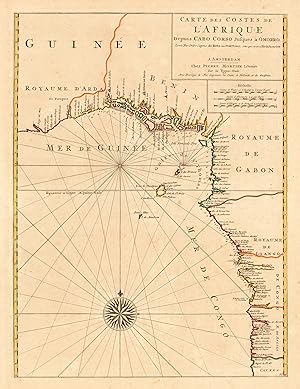
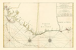
Carte Particuliere des Costes de l'Afrique qui comprend une Partie dela GuinĂ e et Partie de Mina etc.
Verlag: Pierre Mortier, Amsterdam, 1693
Anbieter: Argosy Book Store, ABAA, ILAB, New York, NY, USA
Bewertung:
unbound. Map. Copper plate engraving with original hand coloring. Image measures 19.5 x 31". This beautiful chart of the coast of Africa extends from Palmares (close to modern day Conakry in Guinea) to Fort Nassau in Ghana including parts of the Gold Coast, Pepper Coast or Grain Coast and the Ivory Coast. The map covers the coastline of modern day Guinea, Sierra Leone, Liberia, Cote d'Ivoire and Ghana. The chart offers incredible coastal detail and labels several towns, capes, bays, forts and rivers. Two beautiful compass roses are included. The map is in good condition with large margins. Minor wear along the centerfold with some offsetting and foxing at places. Original pressmark is visible. Two sheets joined at center, with horizontal fold. Pierre Mortier (1661-1711) was a Dutch cartographer, engraver, and printseller who worked in Amsterdam. He used advanced Dutch printing methods to produce high quality editions of contemporary French maps by cartographers such as De L'Isle, Sanson, Jaillot, de Fer and De Wit. His greatest feat was the nautical atlas "Le Neptune Francois" or "Suite de Neptune Francois", considered to contain the most beautiful examples of cartographic art. Most of the charts from the atlas were based on earlier manuscripts by the Portuguese, who were the first explorers of the African coast. This chart is a beautiful example of one of those charts.
-
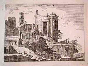
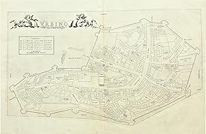
Pianta planimetrica schematica della cittŕ.
-
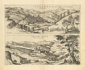
Nocerra Ville de l'Etat del'Eglise, dans le Duché de Spoletp - Castel Novo. Entre Lorette & Rome
Verlag: Nocera - Castelnuovo
Anbieter: Sergio Trippini, Gavirate, Italien
Bewertung:
Stampa. antica ed originale, con vedute delle delle cittadine di Nocera e Castelnuovo in unico foglio. Autore: Mortier Pierre. Luogo: Nocera - Castelnuovo. Anno: 1724. Tecnica: incisione in rame. Dimensioni: 408x515 mm.
-
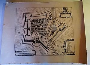
Traw Ville de la Republique de Venise dans la Dalmatie
Verlag: Pierre Mortier, Amsterdam, 1704
Anbieter: Antiquariat Reinhold Berg eK Inh. R.Berg, Regensburg, Deutschland
Bewertung:
Karte
Other. Original copper engraving. Uncolored. Fascinating plant of Traw and the Bua island. Mortier, publisher active in Amsterdam at the beginning of the century, reprinted the "Theatrum Civitatum. Italiae" of Blaeu in 1663 adding a fourth volume, relating to northern Italy, Dalmatia, Greece and Tuscany. Beautiful specimen with wide margins. In excellent condition. 415 by 510mm (16Ľ by 20 inches).
-
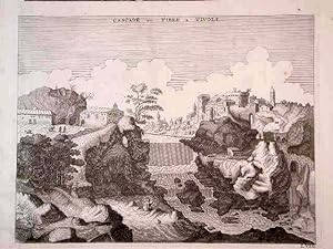
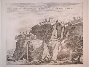
Cascate del Teverone a Tivoli piů basse della Grande
Verlag: Tivoli
Anbieter: Sergio Trippini, Gavirate, Italien
Bewertung:
Decorativa veduta delle cascate a Tivoli.
-
Utriusque Portus Ostiae Delineatio
Verlag: Ostia
Anbieter: Sergio Trippini, Gavirate, Italien
Bewertung:
Pianta planimetrica prospettica della cittŕ, in basso rimandi da 1 a 14.
-
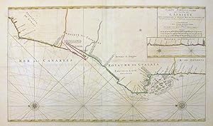
Carte Particuliere des Costes de l'Afrique qui comprend le Royaume de Gualata etc.
Verlag: Pierre Mortier, Amsterdam, 1693
Anbieter: Argosy Book Store, ABAA, ILAB, New York, NY, USA
Bewertung:
unbound. Map. Copper plate engraving with original hand coloring. Image measures 19.5 x 33". The large chart of the NW coast of Africa extends from Cape Boujdour south as far as the Senegal River, with the southern part of the coast depicted in an inset. Oriented to the left, it depicts the region of modern day Western Sahara, Mauritania and Senegal. The sea chart offers incredible detail along the coast noting towns, rivers, islands and coastal features including banks and depth soundings. The map is in good condition with large margins. Minor wear along the centerfold with some offsetting and foxing, large horizontal fold. Original pressmark is visible. Two sheets joined at center. Pierre Mortier (1661-1711) was a Dutch cartographer, engraver, and printseller who worked in Amsterdam. He used advanced Dutch printing methods to produce high quality editions of contemporary French maps by cartographers such as De L'Isle, Sanson, Jaillot, de Fer and De Wit. His greatest feat was the nautical atlas "Le Neptune Francois" or "Suite de Neptune Francois", considered to contain the most beautiful examples of cartographic art. Most of the charts from the atlas were based on earlier manuscripts by the Portuguese, who were the first explorers of the African coast.
-
Carte Des Costes de L Afrique Depuis Cabo Corso Jusques ŕ Omorro. Levée Par Ordre Expres des Roys De Portugal sous qui on en a Fait la Decouverte.
Verlag: Pierre Mortier, Amsterdam, 1705
Anbieter: Antiquariat Reinhold Berg eK Inh. R.Berg, Regensburg, Deutschland
Bewertung:
Karte
Other. Copper engraving, hand colored in outline as published. In excellent condition. 577 by 435mm (22ľ by 17Ľ inches). 577 by 435mm (22ľ by 17Ľ inches).
-
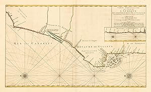
Carte Particuliere Des Costes De L Afrique Qui comprend le Royaume De Gualata &c. Levée Par Ordre Expres des Roys De Portugal sous qui on en a Fait la Decouverte.
Verlag: Pierre Mortier, Amsterdam, 1705
Anbieter: Antiquariat Reinhold Berg eK Inh. R.Berg, Regensburg, Deutschland
Bewertung:
Karte
Other. Copper engraving, hand colored in outline as published. In excellent condition. 497 by 842mm (19˝ by 33Ľ inches). 497 by 842mm (19˝ by 33Ľ inches).
-
Partie du Royaume de Boheme.
Verlag: Amsterdam (ca. 1700)., 1700
Kupferkarte, altkolor. Unter Passep. Kl. Bereibung in der Bugfalte. Zeigt das gesamte Gebiet Böhmens und Mährens. Gewicht in Gramm: 500.
-
Carte Particuliere Des Costes De L Afrique Qui comprend le Royaume De Cacheo le Province De Gelofo &c. Levée Par Ordre Expres des Roys De Portugal sous qui on en a Fait la Decouverte.
Verlag: Pierre Mortier, Amsterdam, 1705
Anbieter: Antiquariat Reinhold Berg eK Inh. R.Berg, Regensburg, Deutschland
Bewertung:
Karte
Other. Copper engraving, hand colored in outline as published. In excellent condition. 548 by 768mm (21˝ by 30Ľ inches). 548 by 768mm (21˝ by 30Ľ inches).
-
Carte Particuliere Des Costes De L Afrique Qui comprend une Partie De La Guinée et Partie De Mina &c. Levée Par Ordre Expres des Roys De Portugal sous qui on en a Fait la Decouverte.
Verlag: Pierre Mortier, Amsterdam, 1705
Anbieter: Antiquariat Reinhold Berg eK Inh. R.Berg, Regensburg, Deutschland
Bewertung:
Karte
Other. Copper engraving, hand colored in outline as published. In excellent condition. 507 by 792mm (20 by 31Ľ inches). 507 by 792mm (20 by 31Ľ inches).
-
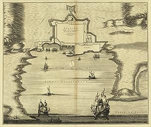
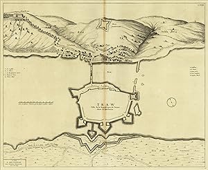
Spalato. Ville des Venetiens. Elle est dans la Dalmatie. a Amsterdam par Pierrre Moriter Avec Privilege.
Verlag: Pierre Mortier, Amsterdam, 1704
Anbieter: Antiquariat Reinhold Berg eK Inh. R.Berg, Regensburg, Deutschland
Bewertung:
Karte
Other. Original copper engraving. Uncolored. Fascinating plant of Split enriched by ships sailing in the Gulf of Venice. Mortier, publisher active in Amsterdam at the beginning of the century, reprinted the "Theatrum CivitatumÖItaliae" of Blaeu in 1663, adding a fourth volume, relating to northern Italy and Tuscany. In excellent condition. 448 by 530mm (17ľ by 20ľ inches).
-
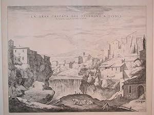
La Gran Cascata del Teverone a Tivoli
Verlag: Tivoli
Anbieter: Sergio Trippini, Gavirate, Italien
Bewertung:
Bella e decorativa veduta della cascata al centro della cittadina.