Gesamtpreis (1 Artikel Artikel):
Versandziel:

moule thomas (143 Ergebnisse)
Direkt zu den wichtigsten Suchergebnissen
Produktart
- Alle Produktarten
- Bücher (130)
- Magazine & Zeitschriften
- Comics
- Noten
- Kunst, Grafik & Poster
- Fotografien
- Karten (13)
-
Manuskripte &
Papierantiquitäten
Zustand
Einband
Weitere Eigenschaften
Gratisversand
Land des Verkäufers
Verkäuferbewertung
-
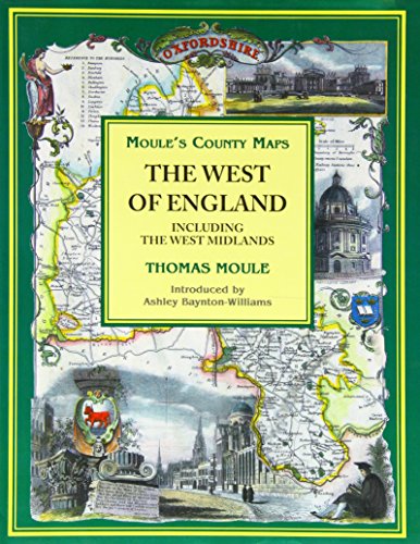
Moule's County Maps: West of England Including the West Midlands
Verlag: Bracken Books, 1994
ISBN 10: 1858911966ISBN 13: 9781858911960
Buch
Hardback. Zustand: Very Good. The book has been read, but is in excellent condition. Pages are intact and not marred by notes or highlighting. The spine remains undamaged.
Mehr Angebote von anderen Verkäufern bei ZVAB
Gebraucht ab EUR 2,02
-
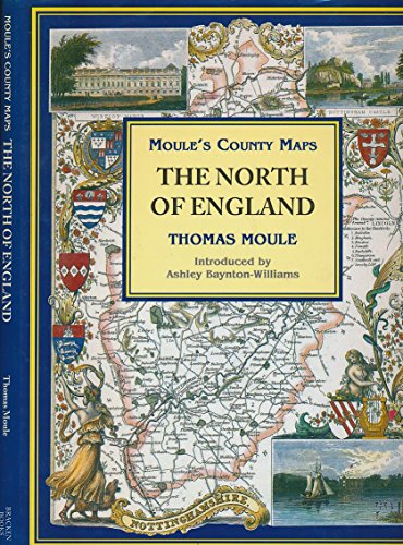
The North of England (Moule's county maps)
Verlag: Studio, 1994
ISBN 10: 185891194XISBN 13: 9781858911946
Buch
Hardback. Zustand: Very Good. The book has been read, but is in excellent condition. Pages are intact and not marred by notes or highlighting. The spine remains undamaged.
Mehr Angebote von anderen Verkäufern bei ZVAB
Gebraucht ab EUR 2,45
-
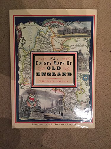
THE COUNTY MAPS OF OLD ENGLAND.
Verlag: Dolphin Publications, 1993
ISBN 10: 1858910382ISBN 13: 9781858910383
Buch
Paperback. Zustand: Very Good. The book has been read, but is in excellent condition. Pages are intact and not marred by notes or highlighting. The spine remains undamaged.
Mehr Angebote von anderen Verkäufern bei ZVAB
Gebraucht ab EUR 4,28
-
The County Maps of Old England
Verlag: Studio Editions, 1990
ISBN 10: 1851704035ISBN 13: 9781851704033
Buch Erstausgabe
Zustand: Very Good. 1st. Used book that is in excellent condition. May show signs of wear or have minor defects.
Mehr Angebote von anderen Verkäufern bei ZVAB
Gebraucht ab EUR 9,69
Mehr entdecken Hardcover Softcover Erstausgabe
-
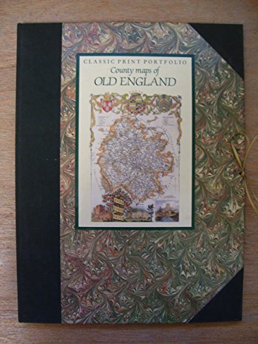
Classic Print Portfolio - County Maps of Old England
Verlag: Studio Editions, 1991
ISBN 10: 1851706852ISBN 13: 9781851706853
Buch
Paperback. Zustand: Very Good. The book has been read, but is in excellent condition. Pages are intact and not marred by notes or highlighting. The spine remains undamaged.
Mehr Angebote von anderen Verkäufern bei ZVAB
Gebraucht ab EUR 8,08
-
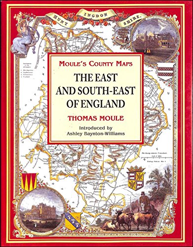
The East and South-East of England (Moule's county maps)
Verlag: Bracken Books, 1994
ISBN 10: 1858911990ISBN 13: 9781858911991
Buch
Hardback. Zustand: Very Good. The book has been read, but is in excellent condition. Pages are intact and not marred by notes or highlighting. The spine remains undamaged.
Mehr Angebote von anderen Verkäufern bei ZVAB
Gebraucht ab EUR 11,16
-

The County Maps of Old England (Hardcover)
Verlag: Studio Editions
Anbieter: Wonder Book, Frederick, MD, USA
Bewertung:

Zustand: Very Good. Very Good condition. Good dust jacket. (Great Britain, England, maps) [ISBN 1851704035] A copy that may have a few cosmetic defects. May also contain light spine creasing or a few markings such as an owner's name, short gifter's inscription or light stamp. Bundled media such as CDs, DVDs, floppy disks or access codes may not be included.
-
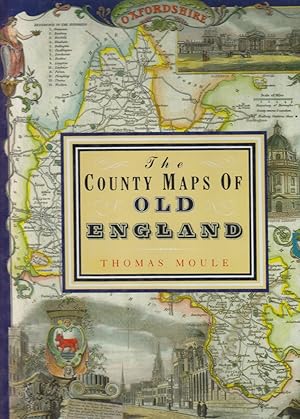
The County Maps of Old England. Introd. by Roderick Barron.
Verlag: London Studio Editions (Reprint d Ausg v 1830 u 1842), 1990
Buch
Hardcover. Zustand: Gut. Schutzumschlag. 126 S. Mit vielen farb. Karten engl. Grafschaften (Faks. d. Karten aus dem 19.Jh.). Folio(. Orig.-Ln. (Ecken etwas berieben, Schutzumschl. m. leichten Gebrauchsspuren). Thomas Moule (1784-1851) war einer der bekanntesten Kartographen des frühen Viktorianischen Zeitalters. In engl. Sprache. Innen sehr gut erhalten.
-
Bibliotheca Heraldica Magnae Britanniae an Analytical Catalogue of Books on Genealogy, Heraldry, Nobility, Knighthood and Ceremonies.
Verlag: Heraldry Today, 1966
Anbieter: Scarthin Books ABA, ILAB., Cromford, Vereinigtes Königreich
Bewertung:
Hardcover. Zustand: Very Good. No Jacket. London: Heraldry Today, 1966. Reprint . Book Publisher's Cloth. Very Good/No Jacket. Octavo. Reproduced from the edition of 1822. 668 pages. Frontispiece of William Camden and other illustrations, mainly as chapter headings. Bound in the original cream buckram boards. No names or inscriptions.
-
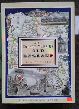
THE COUNTY MAPS OF OLD ENGLAND. WITH AN INTRODUCTION BY RODERICK BARRON.
Erscheinungsdatum: 1994
Anbieter: Graham York Rare Books ABA ILAB, Honiton, Vereinigtes Königreich
Verbandsmitglied: ABA ILAB PBFA
Bewertung:

Karte
Zustand: Very good. 1994, London, Studio Editions, elephant folio, reprint, pp127, colour maps, blue cloth in dustwrapper.
-
The County Maps Of Old England. Introduction by Roderick Barron.
Erscheinungsdatum: 1990
Anbieter: Libreria Piani, Monte San Pietro, BO, Italien
Bewertung:
Buch
London, Studio, 1990, 4to (cm. 36 x 26,5) legatura tutta tela con titoli dorati al dorso e sovraccopertina illustrata a colori (piccolo strappo) pp. 127 con 56 carte a colori a piena pagina nel testo.
-
Bibliotheca Heraldica Magnć Brittannić. An Analytical Catalogue of Books on Genealogy, Heraldry, Nobility, Knighthood, & Ceremonies.
Heraldry Today, London 1966. 8vo. XVI+668 pages. Illustrated in b/w. Orig. offwhite cloth. * Reproduced from the original edition of 1822.
-
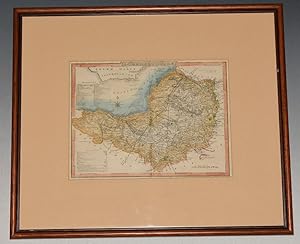
ORIGINAL ENGRAVED MAP OF SOMERSETSHIRE. With later hand-colouring.
Verlag: Moule, ca1837., 1837
Anbieter: PROCTOR / THE ANTIQUE MAP & BOOKSHOP, DORCHESTER, Vereinigtes Königreich
Verbandsmitglied: PBFA
Bewertung:
Karte
Framed size 16 x 14 inches. Size within mount approx 9 x 7 inches. In natural wood frame behind glass, with wide ivory mount. In very good condition. Vertical centre crease from original binding. Some small light foxing spots around edges and text. Else a clean and bright example. With later hand-colouring.
-
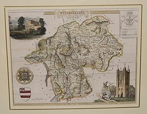
ORIGINAL ENGRAVED MAP OF WESTMORELAND. From ?The English Counties Delineated?. Or, A Topographical Description of England.
Verlag: 1837., 1837
Anbieter: PROCTOR / THE ANTIQUE MAP & BOOKSHOP, DORCHESTER, Vereinigtes Königreich
Verbandsmitglied: PBFA
Bewertung:
Karte
Engraved surface: 10 x 8 ins. In ivory mount with gilt line 14 x 12 ins. T. Moule (1754 - 1851), an authority on heraldry, embellished his maps with amorials and other features. His was the last series of British Maps to follow the tradition of decorative armorial cartography and they make a pleasing and attractive addition to any home. Nice later hand colouring. Attractive map.
-
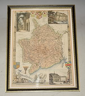
ORIGINAL ENGRAVED MAP OF MONMOUTHSHIRE. From ?The English Counties Delineated?. Or, A Topographical Description of England.
Verlag: 1831, 1831
Anbieter: PROCTOR / THE ANTIQUE MAP & BOOKSHOP, DORCHESTER, Vereinigtes Königreich
Verbandsmitglied: PBFA
Bewertung:
Karte
Framed size 22.5cm x 28.5cm. Engraved surface approx 20cm x 26.5cm. In black and gold Hogarth wood frame behind glass. In very good condition. Nice later hand colouring. Attractive map. T.Moule (1754 - 1851), an authority on heraldry, embellished his maps with amorials and other features. His was the last series of British Maps to follow the tradition of decorative armorial cartography and they make a pleasing and attractive addition to any home.
-

ORIGINAL HAND COLOURED ENGRAVED MAP OF MIDDLESEX From ?The English Counties Delineated?. Or, A Topographical Description of England.
Verlag: 1837., 1837
Anbieter: PROCTOR / THE ANTIQUE MAP & BOOKSHOP, DORCHESTER, Vereinigtes Königreich
Verbandsmitglied: PBFA
Bewertung:
Karte
Hand coloured engraved map, in black and gold wooden frame with glass. Size in frame 29.5cm x 23cm. Engraved surface approx 26.5cm x 20cm. In very good condition. A very clean with attractive colouring. Nice later hand colouring. Decorative border with views of Westminster Bridge & Abbey and Buckingham Palace. T. Moule (1754 - 1851), an authority on heraldry, embellished his maps with amorials and other features. His was the last series of British Maps to follow the tradition of decorative armorial cartography and they make a pleasing and attractive addition to any home.
-

Bibliotheca Heraldica Magnć Britannić : An Analytical Catalogue of Books on Genealogy, Heraldry, Nobility, Knighthood,& Ceremonies, With a List of Provincial Visitations, Pedigrees, Collections of Arms, and Other Manuscripts; And a Suppleme
Verlag: Forgotten Books, 2015
ISBN 10: 1331986931ISBN 13: 9781331986935
Buch
Zustand: Sehr gut. Zustand: Sehr gut - Gepflegter, sauberer Zustand. | Seiten: 702 | Sprache: Englisch.
-
Heraldry of Fish. Notices of the Principal Families Bearing Fish in their Arms.
Verlag: London, John Van Voorst,, 1842
Buch Erstausgabe
8°, cloth-bound ca. 1900. 1st ed. Illustrated by engravings on wood, XV, 250 p. Binding minimal rubbed, otherwise fine copy. Sprache: Englisch Gewicht in Gramm: 0.
-
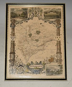
ORIGINAL ENGRAVED MAP OF RUTLANDSHIRE. From ?The English Counties Delineated?. Or, A Topographical Description of England.
Verlag: 1837., 1837
Anbieter: PROCTOR / THE ANTIQUE MAP & BOOKSHOP, DORCHESTER, Vereinigtes Königreich
Verbandsmitglied: PBFA
Bewertung:
Karte
Framed size 22.5cm x 28.5cm. Engraved surface approx 20cm x 26.5cm. In black and gold Hogarth wood frame behind glass. In very good condition. Nice later hand colouring. Attractive map. T.Moule (1754 - 1851), an authority on heraldry, embellished his maps with amorials and other features. His was the last series of British Maps to follow the tradition of decorative armorial cartography and they make a pleasing and attractive addition to any home.
-
Winkle's Architectural and Picturesque Illustrations of the Cathedral Churches of England and Wales; The drawings made from sketches taken expressly for this work, By Robert Garland, Architect. Volumes 1 & 2 (of 3)
Verlag: London. Effingham Wilson and Charles Tilt. 1836-1838, 1838
Anbieter: J. Patrick McGahern Books Inc. (ABAC), Ottawa, ON, Kanada
Verbandsmitglied: ABAC ILAB IOBA
Bewertung:
Hardcover. 4to, 26.5cm, xx,144 & viii,140pp., with 2 steel engraved frontispieces and 119 steel engraved plates, tissue guards, original dark green blind decorated cloth, gilt spine titles & decoration, front board on Volume One detached, contents very good volume two near fine (bkds). - Cathedrals studied are Salisbury, Canterbury, York, St. Paul's, Wells, Rochester, Winchester, Lincoln, Chichester, Ely, Peterborough, Norwich, Exeter, Bristol and Oxford. The striking collection of engravings are by Henry and B. Winkles from drawings by Robert Garland, Hablot Browne, John Salmon and J. Archer. Each cathedral has an engraved plan drawn by Robert Garland.
-
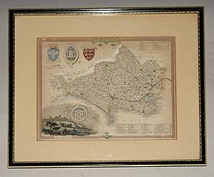
ORIGINAL ENGRAVED MAP OF DORSETSHIRE. Dorset From ?The English Counties Delineated?. Or, A Topographical Description of England.
Verlag: 1836, 1836
Anbieter: PROCTOR / THE ANTIQUE MAP & BOOKSHOP, DORCHESTER, Vereinigtes Königreich
Verbandsmitglied: PBFA
Bewertung:
Karte
In black and gilt wooden frame, with glass. Size of engraved surface 10.5 x 8.5 inches. Frame 14.5 x 12.5 inches. In very good condition. Some light tanning & a few small foxing spots. A few small fly spots lower margin. With later hand-colouring. T.Moule (1754 - 1851), an authority on heraldry, embellished his maps with amorials and other features. His was the last series of British Maps to follow the tradition of decorative armorial cartography and they make a pleasing and attractive addition to any home. This map has two shields, two seals and a vingette of Shaftesbury. Also the Hundreds and Liberties are numbered and listed.
-

Heraldry of Fish: Notices of the Principal Families Bearing Fish in Their Arms
Verlag: Legare Street Press, 2022
ISBN 10: 1016986114ISBN 13: 9781016986113
Buch
Zustand: New.
-
Heraldry of Fish: Notices of the Principal Families Bearing Fish in their Arms.
Verlag: London: John Van Voorst
Anbieter: Powell's Bookstores Chicago, ABAA, Chicago, IL, USA
Bewertung:
Zustand: Used - Very Good. 1842. 1st Cloth, 250 pp., illustrated throughout with wood engravings. Red pencil check marks in margins throughout. Otherwise, very bright copy and overall, Very Sound.
-

An Essay On the Roman Villas of the Augustan Age: Their Architectural Disposition and Enrichments and On the Remains of Roman Domestic Edifices Disco
Verlag: LIGHTNING SOURCE INC, 2016
ISBN 10: 1358672385ISBN 13: 9781358672385
Buch
Gebunden. Zustand: New.
-
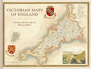
England\ s Victorian Maps
Verlag: Batsford Books|Batsford, 2018
ISBN 10: 1849944970ISBN 13: 9781849944977
Buch
Zustand: New. The most beautiful Victorian maps of England s counties and cities - in large format - by one of Britain s great cartographer s Thomas Moule.The most beautiful Victorian maps of England s counties and cities by one of Britain s great cartographer s Tho.
-
Heraldry of Fish. Notices of the Principal Families Bearing Fish in their Arms
Verlag: John Van Voorst, London, 1842
Anbieter: Graphem. Kunst- und Buchantiquariat, Berlin, Deutschland
Bewertung:
gr 8°, Lwd., XV, 250 S. - Einband berieben und teilw. stärker bestoßen, Bindungen an den Innendeckeln fixiert, die ersten und letzten Seiten etwas stockfleckig. Buch.
-
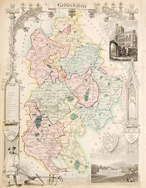
Bedforshire.
Verlag: London; George Virtue. 1842, 1842
Anbieter: Peter Harrington. ABA/ ILAB., London, Vereinigtes Königreich
Verbandsmitglied: ABA ILAB PBFA
Bewertung:
Highly decorative map with ornate border in a Gothic arch, coat of arms, scale and reference to the hundreds. Inset views of Dunstable Priory and Woburn Abbey. From the atlas The English Counties Delineated. Size: 270 x 210 mm. Steel engraving. Original hand colouring. Fine condition.
-
Bibliotheca Heraldica Magnć Britannić: An Analytical Catalogue of Books On Genealogy, Heraldry, Nobility, Knighthood, & Ceremonies: With a List of Pro
Verlag: ARKOSE PR, 2015
ISBN 10: 1344931154ISBN 13: 9781344931151
Buch
Gebunden. Zustand: New.
-
Heraldry of Fish. Notices of the Principal Families Bearing Fish in their Arms
Verlag: John van Voorst, London, 1842
Anbieter: Graphem. Kunst- und Buchantiquariat, Berlin, Deutschland
Bewertung:
8°, Ganzledereinbd. m. Zierbünden und goldgeprägtem Rücken, XV, 250 S. m. zumeist prachtvoll handkolorierten Wappen - Einband teiwl. stärker berieben, sonst gutes unikales Exemplar. Ex Libris. Buch.
-

Essex.
Verlag: London: George Virtue. 1842, 1842
Anbieter: Peter Harrington. ABA/ ILAB., London, Vereinigtes Königreich
Verbandsmitglied: ABA ILAB PBFA
Bewertung:
Highly decorative map of Essex with border, coats of arms, scale and reference to the hundreds. Inset views of Chelmsford top right and Southend bottom right. Steel engraving. Later and colouring. Good condition. Some staining to outer margins.