Gesamtpreis (1 Artikel Artikel):
Versandziel:

mount page (18 Ergebnisse)
Direkt zu den wichtigsten Suchergebnissen
Produktart
- Alle Produktarten
- Bücher (12)
- Magazine & Zeitschriften
- Comics
- Noten
- Kunst, Grafik & Poster (1)
- Fotografien
- Karten (5)
-
Manuskripte &
Papierantiquitäten
Zustand
- Alle
- Neu
- Antiquarisch/Gebraucht
Einband
- alle Einbände
- Hardcover (2)
- Softcover
Weitere Eigenschaften
- Erstausgabe (1)
- Signiert
- Schutzumschlag
- Angebotsfoto (16)
Land des Verkäufers
Verkäuferbewertung
-
The haven of St. Malo
Verlag: Artist: Mount & Page; issued in: London ; ca: ; -, 1750
Anbieter: Antique Sommer& Sapunaru KG, München, Deutschland
Bewertung:

Technic: Copper print; colorit: original colored; condition: Very good, size (in cm): 39,5 x 23; - Map shows the city and the harbour of St. Malo and some smal islands.
-
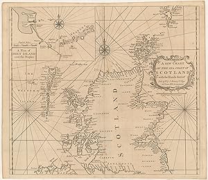
A new Chart of the sea Coast of Scotland with the Islands thereof
Verlag: [ca. 1751], 1751
Anbieter: Maggs Bros. Ltd ABA, ILAB, PBFA, BA, London, Vereinigtes Königreich
Verbandsmitglied: ABA ILAB PBFA
Bewertung:

Double-page engraved chart, 490 by 570 mm. A good example. London : William & John Mount & Thomas Page (II), A mid century version of this chart. The inset depicts Holy Island and the Staples.
-
![Bild des Verkäufers für [Untitled Chart of 'The Island of Diego Rays'] zum Verkauf von Maggs Bros. Ltd ABA, ILAB, PBFA, BA](https://pictures.abebooks.com/inventory/md/md30971887233.jpg)
[Untitled Chart of 'The Island of Diego Rays']
Verlag: [ca. 1745], 1745
Anbieter: Maggs Bros. Ltd ABA, ILAB, PBFA, BA, London, Vereinigtes Königreich
Verbandsmitglied: ABA ILAB PBFA
Bewertung:
Copperplate engraving, 425 x 543 mm. London : William Mount & Thomas Page (II), Very scarce chart of the island of 'Diego Rays', now Isle Rodrigues part of the Mascarene Islands in the Indian Ocean, named after the Portuguese explorer Dom Diego Rodrigues. It was added to late edition of John Thornton's The English Pilot . for the Oriental Navigation . published by the Mount and Page family.
-
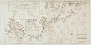
A Chart for the Newcastle Trade Describeing the Sea Coasts of England from the South Foreland to New:castle w.th the Soundings, Sands, Shoals, Harbours Buoys Beacons and Seamarks, upon ye said Coasts.
Erscheinungsdatum: 1747
Anbieter: Altea Antique Maps, London, Vereinigtes Königreich
Verbandsmitglied: ABA ILAB PBFA
Bewertung:
Karte
London: W. & J. Mount and T. Page, 1747. Two sheets conjined, total 510 x 1000mm. The east coast of England, orientatedwith north to the right, showing from Hythe in Kent to Tynemouth in what was Northumberland, also showing the Thames to London. Insets show the Harwich roads, the Yarmouth Sands and a detail of the coast from Sunderland to Blyth. This chart was first published in Mount & Page's 'The English Pilot. The Second Book' in 1729. It was replaced with a copy engraved by Mynde in 1770.
-
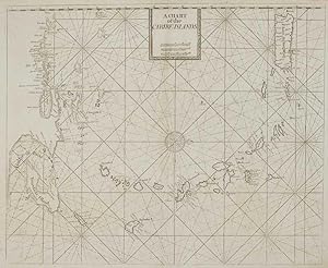
A Chart of the Caribe Islands.
Erscheinungsdatum: 1748
Anbieter: Altea Antique Maps, London, Vereinigtes Königreich
Verbandsmitglied: ABA ILAB PBFA
Bewertung:
Karte
London: W. & J. Mount and T. Page, 1748. 435 x 530mm. A chart of the Lesser Antilles, orientated with north to the right, showing from Purto Rico south to Trinidad and the Gulf of Paria. This example comes from Mount & Page's 'The English Pilot. The Fourth Book Describing The West India Navigation.', the first sea atlas of America containing charts only from English sources.
-
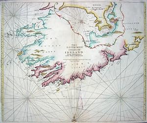
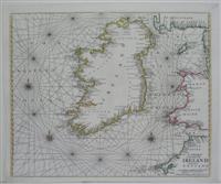
The South-West Coast of Ireland from Dungarvan to the River Shannon/ Kinsale Harbour
Verlag: Artist: Mount & Page; issued in: London ; ca: ; -, 1748
Anbieter: Antique Sommer& Sapunaru KG, München, Deutschland
Bewertung:
Technic: Copper print; colorit: original colored; condition: Some restoration at centerfold, missing part on lower centerfold replaced, size (in cm): 43,5 x 53; - Representation of south west Irland, on iset map Kinsale near Cork; - Special feature: From the English Pilot.
-
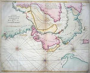
A chart of the seacoasts of Irland from Dublin to London- Derry/ Lough Foyle or the passage to London- Derry
Verlag: Artist: Mount & Page; issued in: London ; ca: ; -, 1748
Anbieter: Antique Sommer& Sapunaru KG, München, Deutschland
Bewertung:
Technic: Copper print; colorit: original colored; condition: Corners perfectly replaced, some restoration at the center fold, size (in cm): 43,5 x 54; - Map shows the coast of Irland from Dublin to Londonderry, on inset map shows the passage to Londonderry; - Special feature: From the English Pilot, hightened with Gold.
-
A Chart of the Coast of Ireland and Part of England
Verlag: London, 1740
Anbieter: Alexandre Antique Prints, Maps & Books, Toronto, ON, Kanada
Bewertung:
Karte
Zustand: Excellent. Size : 450x540 (mm), Hand Colored in Outline.
-

A Chart of New York Harbour with the banks Soundings and sailing marks from the most accurate Surveys & Observations
Verlag: London, , c.1784., 1784
Anbieter: Alexandre Antique Prints, Maps & Books, Toronto, ON, Kanada
Bewertung:
A rare post revolutionary chart of New York Harbour showing shoals, channels, soundings, navigational sightings, and landmarks. This map only appeared in the of the English Pilot. Size: 605 x 465, 23 3/4" x 18 1/4". Hand Colored, Two mirror image faint brown area located near the upper left and right margins. Laid on acid free tissue paper for long term preservation. References: Sellers 1236.
-
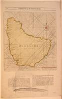
Barbados
Verlag: London, 1773
Anbieter: Alexandre Antique Prints, Maps & Books, Toronto, ON, Kanada
Bewertung:
Karte
Zustand: Very Good. Size : 290x255 (mm), 11.375x10 (Inches), Hand Colored.
-
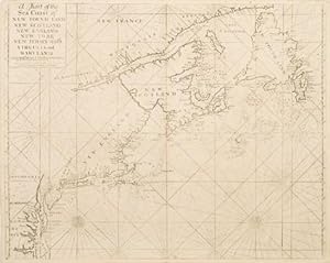
A Chart of the Coast of Newfoundland, New Scotland, New England, New York, New Jersey with Virginia and Maryland.
Verlag: London. 1759, 1759
Anbieter: Peter Harrington. ABA/ ILAB., London, Vereinigtes Königreich
Verbandsmitglied: ABA ILAB PBFA
Bewertung:
Detailed chart of the eastern seaboard of North America, from Virginia to Newfoundland, with compass points at sea, rhumb lines, sand banks and depth soundings, originally published in The English Pilot, fourth Book. Size: 575 x 450 mm Copper engraving. Uncoloured. Very good condition.
-
[The English Pilot Parts I and III] The English Pilot for the Southern Navigation: Describing the Sea-Coasts, Capes, Headlands, Bays, Roads, Harbours, Rivers and Ports: together with the Soundings, Sands, Rocks and Dangers on the Coast of England, Scotland, Ireland, Holland, Flanders, Spain, Portugal, to the Streight's-Mouth; with the Coasts of Barbary, and off to the Canary, Madeira, Cape de Verde and Western Islands Shewing the Courses and Distances from on Place to another; The Setting of the Tides and Currents; the Ebbing and Flowing of the Sea, &c. The English Pilot. Part III. Describing The Sea-Coasts, Capes, Head-Lands, Bays, Roads, Harbours, Rivers and Ports; Together with the Soundings, Sands, Rocks and Dangers in the Whole Mediterranean Sea, Likewise The Courses and distances from on Place to another. The Setting of the Tides and Currents. The Ebbing and Flowing of the Sea. The Bearing, Distance and Prospects of the Land, and how they shew themselves at Sea. Carefully Correct
Verlag: J. Mount, and T. Page, London, 1771
Anbieter: Argosy Book Store, ABAA, ILAB, New York, NY, USA
Bewertung:
hardcover. Zustand: very good. Folio atlas. Two parts (I and III) bound in one volume, London: 1771. Part I: 46 pp of text; 22 double page and folding maps plus 2 small maps and many additional charts and views. Ink inscription on title page reads "1774 John Hamilton Ought This Book-Bought of James Alex.(?) Stewart". Stamped name in margin of one page of text. Part III: 43 pp of text; 17 double page or folding maps, 34 half page maps and numerous topographical and panoramic views. Ink inscription "John Hamilton" on title page. Stamped name on title page and two maps. Numerous woodcut elevations and additional engraved maps throughout both volumes. Rebound in blue bukram with gilt title stamped on spine. Stamp from G.H. Crawford Co. Bookbinders, Dec. 1955 on inside back free fly page. Light scattered foxing and a few stains throughout with more toning in the final 8 pages. Small chip to title page and one map. Small wormholes to a few maps. In general, maps are crisp and clean. Beautiful composite atlas with a series of stunning maps and charts and explicit sailing directions and notations. Part I has charts of the River Thames, Newcastle trade routes, the coastlines and various ports of England, Scotland, Ireland, Flanders and the Netherlands, France, Portugal, Spain, the Strait of Gibraltar, the Canary Islands and the Cape Verde Islands. Part III has maps and charts of the Mediterranean from the Strait of Gibraltar to the Levant including the Balearic Islands, southern France, the Barbary Coast, Corsica, Sardinia, Sicily, Malta, Venice and Greece. The "English Pilot" was a sea-chart atlas published in several editions from 1671 to 1803. The Mount family was active in publishing in various manifestations for many generations from the 1650s to 1800.
-
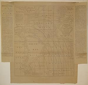
A New and Correct Chart of the Western and Southern Oceans Showing the Variations of the Compass.
Verlag: Mount & Davidson, Tower-Hill, London, 1794
Anbieter: Argosy Book Store, ABAA, ILAB, New York, NY, USA
Bewertung:
unbound. Zustand: very good(+). Map. Uncolored engraving. Image measures 22.75" x 19.5", page including text measures 26.5" x 27 7/8". Beautiful and rare chart of the Atlantic including South America and parts of North America, Europe and Africa. Features lines of magnetic variation, or how much the compass deviates from true north. As explained in the two columns of pasted text, these observations are based upon the work of Dr. Edmond Halley in 1700 with additions in 1744. Other elements include two compass roses, extensive place names, and a note and depiction of fabled sea birds off the eastern coast of South America. The map was originally published by William Mount, John Mount and Thomas Page in "The English Pilot. The Fourth Book" circa 1750. This edition was reissued by William Mount II and James Davidson. Light offsetting. Expert repair to split along original centerfold. The "English Pilot" was a sea-chart atlas published in several editions from 1671 to 1803. The Mount family was active in publishing in various manifestations for many generations from the 1650s to 1800.
-
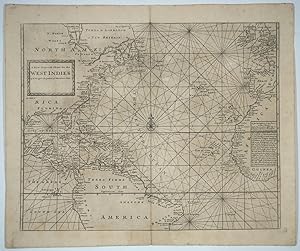
A New Generall Chart for the West Indies of E. Wrights Projection vul. Mercators Chart
Verlag: London, 1750
Anbieter: Antipodean Books, Maps & Prints, ABAA, Garrison, NY, USA
Verbandsmitglied: ABAA ANZAAB ESA ILAB
Bewertung:

Engraved uncolored chart of the entire Gulf of Mexico, extending from Hudsons Bay in North America, through Central America and to St. Salvador in Brazil, with western Europe (England, France, Spain) and West Africa in the east. First published ca. 1750 in The English Pilot. Using Mercator projection, with a text block at the right margin explaining how "to find the distances of two places in this chart". With compass rose, rhumb lines, and decorative title cartouche. Image size: 22 1/4 x 17 3/4". Paper size: 24 1/2 x 20 5/8". References: Phillips, P.L. (Atlases) 10318-2, 10324-2. Very good.
-
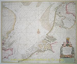
A Chart of Part of the North Sea from the South Foreland to Burnham Flatts, and from Callis Schelling Isle'Copper engraving from "The English Pilot Describing The Sea-Coasts, Capes, Head-Lands, Soundings, Sands, Shoals, Rocks and Dangers, The Bays, Roads, Harbours, Rivers and Ports in the Whole Northern Navigation"' published by W
Anbieter: Inter-Antiquariaat Mefferdt & De Jonge, Amsterdam, Niederlande
Bewertung:
Kunst / Grafik / Poster
A Chart of Part of the North Sea from the South Foreland to Burnham Flatts, and from Callis Schelling Isle'Copper engraving from "The English Pilot Describing The Sea-Coasts, Capes, Head-Lands, Soundings, Sands, Shoals, Rocks and Dangers, The Bays, Roads, Harbours, Rivers and Ports in the Whole Northern Navigation"' published by W. and J. Mount, T. Page and Sons, London 1756. Coloured by a later hand. Size: 44 x 54 cm. The English Pilot was an important British sea-atlas published from 1671 to 1803. Initially published by John Seller, publication of the atlas changed hands periodically, with other publishers including Charles Price, John Thornton, and the Mount & Page firm. The charts from the English Pilot were intended as working charts so there was an effort to make them accurate, although predictably, many seamen complained that the charts were consistently out of date and that changes were slow to appear, a charge leveled at virtually every British, French and American Chart maker, including the respective governments of these nations. Ironically, it was in no small part due to the proprietary nature of the information included in the maps and sailing directions that there was a tendency for commercial pilots to pass the information from mariner to chart-maker more slowly than might otherwise have been the case, although the chart makers on the Thames and otherwise were undoubtedly reluctant to immediately make each and every necessary correction, for fear of undermining the economic viability of their businesses. Price: Euro975,- (excl. VAT/BTW).
-
A Chart of the Sea Coast of New Foundland, New Scotland, New England, New York, New Jersey with Virginia and Maryland
Verlag: W. & I. Mount ; T. Page c. 1750, London, 1750
Anbieter: Alexandre Antique Prints, Maps & Books, Toronto, ON, Kanada
Bewertung:
Karte Erstausgabe
A fine example of Thornton\'s chart of the coast of British Colonial North America, which was the standard used by English sailors for almost a century. The map first appeared in 1689 in the first edition of The English Pilot, The Fourth Book. A second edition of the chart was then created in 1749., Size : 480x595 (mm), 18.90x23.43 (Inches), Black & White Very Good, usual wear at the folds. Mounted on Acid Free Tissue paper for long term preservation.
-
The Coasting Pilot. Describing the Sea-Coasts, Capes, Headlands, Soundings, Sands, Shoals, Rocks and Dangers. The Bays, Roads, Harbours, Rivers and Ports of England, Scotland, Holland, Zealand, Flanders and France. .'bound with: The English Pilot, for the Southern Navigation: describing the Sea-Coasts, Capes, Headlands, Bays, Roads, Harbours, Rivers and Ports: together with the Soundings, Sands, Rocks and Dangers on the Coast of England, Scotland, Ireland, Holland, Flanders, Spain, Portugal, to the Streight's-Mouth; with the Coasts of Barbary, and off to the Canary, Madeira, Cape de Verde and Western-Islands. .bound with: The English Pilot. Describing the Sea-Coasts, Capes, Head-Lands, Soundings, Sands, Shoals, Rocks and Dangers, the Bays, Roads, Harbours, Rivers and Ports in the Whole Northern Navigation; . describing the North Coast of England and Scotland, with the Islands of Orkney, Shetland, Lewis, Farro, Iceland, &c. The sea-coast of Flanders, Zealand, Holland, Germany, Denmark,
Erscheinungsdatum: 1759
Anbieter: Maggs Bros. Ltd ABA, ILAB, PBFA, BA, London, Vereinigtes Königreich
Verbandsmitglied: ABA ILAB PBFA
Bewertung:
London : Mount & Page, 1758; London : Mount & Page, 1758; London : Mount & Page, 1756; London : Mount & Page, 1753; London : Mount & Page, 1753; London : Mount & Page, 1755; London : Mount & Page, 1759. Apparently unique compilation of the six constituent volumes of the English Pilot bound in two, lacking all the inserted charts, but the text complete, retaining the engraved charts in the text (notably in the 'Fourth Book': Antigua, Barbados and Bermuda), with the woodcuts and engravings in fine original wash colour. There is no indication of the charts having been removed; it may be that they were originally bound separately or not purchased at all. The individual volumes of the English Pilot series were the best available English chart books for much of the eighteenth century. The series was begun by John Seller in 1671, with the Northern Navigation, and 1672, Southern Navigation and subsequently expanded by Seller, his successors and heirs with the Mediterranean Pilot (1677), West-India Pilot (1689), West African Pilot (1701) and Oriental Navigation (1703). As a working book, individual editions of the various volumes can be rare. This group, put together at the time of the Seven Years' War / French and Indian War contains several rare printings, but the real significance is the assemblage of the volumes together and the exceptional original colouring throughout, these volumes clearly intended for library use, hence the colouring and fine internal condition. Locations: Coasting Pilot (title-page only): ESTC N44114: only Folger Shakespeare English Pilot Southern: apparently unrecorded, but cf. ESTC N47593. Northern: unrecorded in ESTC. Mediterranean: ESTC N69402: recording the Yale and New York Public Library copies, to which can be added a copy in the National Maritime Museum. West Africa: unrecorded in ESTC; with a copy in the National Maritime Museum. Oriental Navigation: ESTC T218365: recording the Cambridge and National Maritime Museum copies. West India Navigation: ESTC N69401: recording only the Yale copy, with further copies in the Library of Congress and Dartmouth College Library.
-
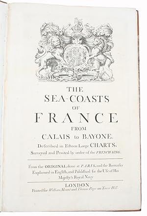
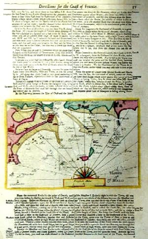
The Sea-Coasts of France, from Calais to Bayone. Described in Fifteen Large Charts. Surveyed and Printed by the order of the French King. From the Original, done at Paris, and the Remarks Explained in English, and Published for the Use of His Majesty'.
London, Printed for William Mount and Thomas Page on Tower Hall, no date (c. 1715). Folio. 53X35 cm. Cont. hcalf with marbled boards. Rebacked and recornered in old style with raised bands. Engraved typographical titlepage with a large engraved vignette showing the English King's Coat of Arms. With all 15 double-page engraved sea-charts (numbered (1)-(15) in lower right corners). Neat repairs to inner margins of free endpapers and titlepage. Some browning to charts. Chart 5 (45x75,5 cm) having the right margin shaved reaching the printed frame. Second edition of this scarce "Atlas Maritime". According to Shirley it was first published by Richard Mount and Thomas Page in 1701 and re-issued with undated title (as this) in ab. 1715, but with the charts unchanged and a new engraved titlepage. A third issue came out in 1737 with a dated title. The fine charts are copied from Pieter Mortier's famous "Neptune Francois" (1693-1702) and reduzed in size."The charts in this early Mount & Page atlas "The Sea-Coasts of France" are re-engravings, reduzed in size, from the charts in the French Neptune of 1693. The charts may also be found in the 1702 edition of Mount and Page's Atlas Maritimus Novus." (Rodney Shirley). - Not in Phillips. - Shirley Vol. II: M.M&P - 12 b.

![Bild des Verkäufers für [The English Pilot Parts I and III] The English Pilot for the Southern Navigation: Describing the Sea-Coasts, Capes, Headlands, Bays, Roads, Harbours, Rivers and Ports: together with the Soundings, Sands, Rocks and Dangers on the Coast of England, Scotland, Ireland, Holland, Flanders, Spain, Portugal, to the Streight's-Mouth; with the Coasts of Barbary, and off to the Canary, Madeira, Cape de Verde and Western Islands Shewing the Courses and Distances from on Place to another; The Setting of the Tides and Currents; the Ebbing and Flowing of the Sea, &c. The English Pilot. Part III. Describing The Sea-Coasts, Capes, Head-Lands, Bays, Roads, Harbours, Rivers and Ports; Together with the Soundings, Sands, Rocks and Dangers in the Whole Mediterranean Sea, Likewise The Courses and distances from on Place to another. The Setting of the Tides and Currents. The Ebbing and Flowing of the Sea. The Bearing, Distance and Prospects of the Land, and how they shew themselves at Sea. Carefully Correct zum Verkauf von Argosy Book Store, ABAA, ILAB](https://pictures.abebooks.com/inventory/md/md3716837647.jpg)