
Gesamtpreis (1 Artikel Artikel):
Versandziel:

ptolemy claudius buckinck arnold (2 Ergebnisse)
Direkt zu den wichtigsten Suchergebnissen
Produktart
- Alle Produktarten
- Bücher (2)
- Magazine & Zeitschriften
- Comics
- Noten
- Kunst, Grafik & Poster
- Fotografien
- Karten
-
Manuskripte &
Papierantiquitäten
Zustand
- Alle
- Neu
- Antiquarisch/Gebraucht
Einband
- alle Einbände
- Hardcover
- Softcover
Weitere Eigenschaften
- Erstausgabe
- Signiert
- Schutzumschlag
- Angebotsfoto
Land des Verkäufers
Verkäuferbewertung
-
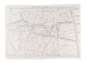
Quinta Asiae Tabula
Verlag: [1507]., 1507
Anbieter: Maggs Bros. Ltd ABA, ILAB, PBFA, BA, London, Vereinigtes Königreich
Verbandsmitglied: ABA ILAB PBFA
Bewertung:

Double-page engraved map, printed on two sheets totalling 355 by 530 mm. Some faint water-staining to the left side, a few instances of mild spotting, otherwise very good. One (later?) annotation in ink to Susa, ?Cittŕ Reale di Persiani? [Rome, Evangelista Tosinus], The second printed map of Persia. Claudius Ptolemy, often considered the ?Father of Geography? was a Greco-Egyptian scholar working in Alexandria, Egypt, circa 150 A.D. His most lasting monument was the Geographia, a summation of the geographical knowledge of the world as it was known in his time, possibly illustrated with maps, but certainly incorporating the technical data necessary to create them. With the fall of the Western Roman Empire, the text was lost to western scholars until about 1406 when the scholar Jacobo d'Angelo prepared a Latin translation of a Greek manuscript. The rediscovery prompted great excitement; numerous manuscript copies were made, many of them containing maps from Ptolemy's calculations. Later, with the invention of printing - particularly printing from engraved plates - Ptolemy's text, and the accompanying maps, formed the basis of the earliest printed atlases. This printing plate was published by Arnold Buckinck in Rome in 1478; his was the second printed edition of Ptolemy with maps, but the first version, issued in 1477, is so rare as to be unobtainable, leaving this as the oldest map of Persia acquirable by a collector. The present example is from the third printing of the atlas, which took place in 1507. It shows all of Persia and part of Turkmenistan, to the southeast of the Caspian Sea.
-
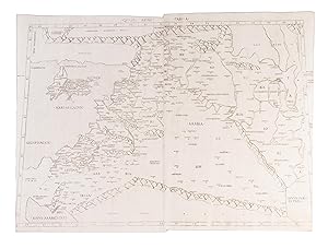
Quarta Asiae Tabula
Verlag: 1507]., 1507
Anbieter: Maggs Bros. Ltd ABA, ILAB, PBFA, BA, London, Vereinigtes Königreich
Verbandsmitglied: ABA ILAB PBFA
Bewertung:
Double-page engraved map, printed on two sheets totalling 370 by 550mm. Trimmed into the marginal text. Two later annotations/additions in ink; a cross above Jerusalem and ?Bagdad? neatly written above Babylon. A few small dark spots to the centre, otherwise very good. [Rome, Evangelista Tosinus, A lovely copy of the second printed map of Mesopotamia (modern-day Iraq), the Levant and the Holy Land. Claudius Ptolemy, often considered the ?Father of Geography? was a Greco-Egyptian scholar working in Alexandria, Egypt, circa 150 A.D. His most lasting monument was the 'Geographia', a summation of the geographical knowledge of the world as it was known in his time, possibly illustrated with maps, but certainly incorporating the technical data necessary to create them. With the fall of the Western Roman Empire, the text was lost to western scholars until about 1406 when the scholar Jacobo d'Angelo prepared a Latin translation of a Greek manuscript. The rediscovery prompted great excitement; numerous manuscript copies were made, many of them containing maps from Ptolemy's calculations. Later, with the invention of printing - particularly printing from engraved plates - Ptolemy's text, and the accompanying maps, formed the basis of the earliest printed atlases. This printing plate was published by Arnold Buckinck in Rome in 1478; his was the second printed edition of Ptolemy with maps, but the first version, issued in 1477, is so rare as to be unobtainable, leaving this as the oldest engraved map of Mesopotamia, the Levant and the Holy Land acquirable by a collector.