Gesamtpreis (1 Artikel Artikel):
Versandziel:

ptolemy claudius (117 Ergebnisse)
Direkt zu den wichtigsten Suchergebnissen
Produktart
- Alle Product Types
- Bücher (114)
- Magazine & Zeitschriften
- Comics
- Noten
- Kunst, Grafik & Poster
- Fotografien
- Karten (3)
- Manuskripte & Papierantiquitäten
Zustand
Einband
Weitere Eigenschaften
- Erstausgabe (4)
- Signiert
- Schutzumschlag
- Angebotsfoto (109)
Gratisversand
- Versand nach USA gratis
Land des Verkäufers
Verkäuferbewertung
-
Paperback. Zustand: Very Good.
-
Ptolemy's Tetrabiblos
Verlag: CreateSpace Independent Publishing Platform, 2011
ISBN 10: 1461118255ISBN 13: 9781461118251
Buch
Zustand: VeryGood. Most items will be dispatched the same or the next working day. A copy that has been read, but is in excellent condition. Pages are intact and not marred by notes or highlighting. The spine remains undamaged.
-
Geography of Claudius Ptolemy
Verlag: Cosimo Classics, 2011
ISBN 10: 1605204382ISBN 13: 9781605204383
Buch
Paperback. Zustand: Very Good. The book has been read, but is in excellent condition. Pages are intact and not marred by notes or highlighting. The spine remains undamaged.
Mehr Angebote von anderen Verkäufern bei ZVAB
Neu ab EUR 28,09
Gebraucht ab EUR 20,05
Mehr entdecken Softcover
-
The Almagest
Verlag: Green Lion Press 2014-12-07, Santa Fe, 2014
ISBN 10: 1888009438ISBN 13: 9781888009439
Buch
paperback. Zustand: New. Language: ENG.
-
Tetrabiblos, Together with the Centiloquy
Verlag: Symbols & Signs, 1974
ISBN 10: 0912504315ISBN 13: 9780912504315
Buch
Zustand: Very Good. Used book that is in excellent condition. May show signs of wear or have minor defects.
-
Tetrabiblos
Verlag: Astrology Center of America, 2005
ISBN 10: 1933303123ISBN 13: 9781933303123
Buch
Zustand: Fine. Englisch.
-

Zustand: New.
-
Zustand: New.
-

Zustand: New.
-

Hardcover. Zustand: Very Good. An oversized facsimile with 26 maps in color and decorative writing in Latin of an unknown edition of Ptolemy's Cosmographia. Bound in beigh cloth with a brown leather spine with gilt decoration by Gray Parrot of Hancock, Maine. There is no title page, English text, or other indication of what this is a facsimile of.
-
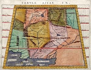
Tabula Asiae IX
Verlag: Artist: Ptolemy/Giovanni Magini Claudius ( - 1617 ) Padua ; ca: 1617; - Giovanni Antonio Magini was an italian astronomer astrologer cartographer and mathematician In 1592 he issued "De Planis Triangulis" by describing the Quadrant Magini also maufactured an atlas of Italy which has been issued by his son in 1620 The moon craterMagnius was named after Magini Claudius Ptolemy ( arround 100- 160 aC) Geographia gives a list of geographic coordinates of spherical longitude and latitude of almost ten thousand point locations on the earth surface as they were known at his times The list is organized in Tabulae which cor- respond to specific regions of the three known continents at that time Africa Asia and Europe Research on Ptolemy?s Geographia, 1555
Anbieter: Antique Sommer& Sapunaru KG, München, Deutschland
Bewertung:

Technic: Copper print; colorit: original colored; condition: Very good, size (in cm): 13 x 17; - Map shows Persia, pakistan and Afganistan.
-
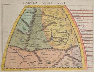
Tabula Asiae VIII
Verlag: Artist: Ptolemy/Giovanni Magini Claudius ( - 1617 ) Padua ; ca: 1617; - Giovanni Antonio Magini was an italian astronomer astrologer cartographer and mathematician In 1592 he issued "De Planis Triangulis" by describing the Quadrant Magini also maufactured an atlas of Italy which has been issued by his son in 1620 The moon craterMagnius was named after Magini Claudius Ptolemy ( arround 100- 160 aC) Geographia gives a list of geographic coordinates of spherical longitude and latitude of almost ten thousand point locations on the earth surface as they were known at his times The list is organized in Tabulae which cor- respond to specific regions of the three known continents at that time Africa Asia and Europe Research on Ptolemy?s Geographia, 1555
Anbieter: Antique Sommer& Sapunaru KG, München, Deutschland
Bewertung:
Technic: Copper print; colorit: original colored; condition: Very good, size (in cm): 13 x 16,5; - Map shows Tartarie, Tibet and partly India.
-
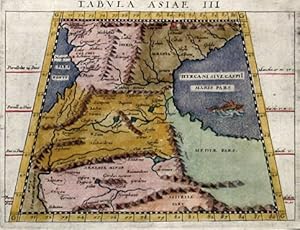
Tabula Asiea III
Verlag: Artist: Ptolemy/Giovanni Magini Claudius ( - 1617 ) Padua ; ca: 1617; - Giovanni Antonio Magini was an italian astronomer astrologer cartographer and mathematician In 1592 he issued "De Planis Triangulis" by describing the Quadrant Magini also maufactured an atlas of Italy which has been issued by his son in 1620 The moon craterMagnius was named after Magini Claudius Ptolemy ( arround 100- 160 aC) Geographia gives a list of geographic coordinates of spherical longitude and latitude of almost ten thousand point locations on the earth surface as they were known at his times The list is organized in Tabulae which cor- respond to specific regions of the three known continents at that time Africa Asia and Europe Research on Ptolemy?s Geographia, 1555
Anbieter: Antique Sommer& Sapunaru KG, München, Deutschland
Bewertung:
Technic: Copper print; colorit: original colored; condition: Very good, size (in cm): 13 x 17; - Map shows Cucasian with Armenia and partly Syria and Turkey.
-
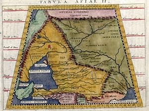
Tabula Asiea II
Verlag: Artist: Ptolemy/Giovanni Magini Claudius ( - 1617 ) Padua ; ca: 1617; - Giovanni Antonio Magini was an italian astronomer astrologer cartographer and mathematician In 1592 he issued "De Planis Triangulis" by describing the Quadrant Magini also maufactured an atlas of Italy which has been issued by his son in 1620 The moon craterMagnius was named after Magini Claudius Ptolemy ( arround 100- 160 aC) Geographia gives a list of geographic coordinates of spherical longitude and latitude of almost ten thousand point locations on the earth surface as they were known at his times The list is organized in Tabulae which cor- respond to specific regions of the three known continents at that time Africa Asia and Europe Research on Ptolemy?s Geographia, 1555
Anbieter: Antique Sommer& Sapunaru KG, München, Deutschland
Bewertung:
Technic: Copper print; colorit: original colored; condition: Very good, size (in cm): 13 x 17; - Interesting map shows in Trapeziod shape former Sarmatia, now partly Russia with the Black Sea, the Ukraine and the peninsula Krim with the Asow sea. On reverse a dexcription with ornamental decoration.
-
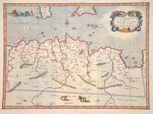
Tab. II Africae, complectens Africam proprie dictam
Verlag: Artist: Ptolemy/ Gerhard Mercator Claudius ( - 1594 ) ; issued in: Duisburg ; ca: 1578; - Gerardus Mercator (1512 - 1594) He was a cartographer philosopher and mathematician He is best known for his work in cartography in particular the world map of 1569 based on a new projection which represented sailing courses of constant bearing as straight lines He is renowned to the present day as the cartographer who created a world map based on a new projection which represented sailing courses of constant bearing as straight lines In his own day he was the world's most famous geographer but in addition he had interests in theology philosophy history mathematics and magnetism as well as being an accomplished engraver calligrapher and maker of globes, 1512
Anbieter: Antique Sommer& Sapunaru KG, München, Deutschland
Bewertung:
Technic: Copper print; colorit: original colored; condition: Very good, size (in cm): 33 x 45; - Map shows total Tunesie with Malta and partly Lybia.
-
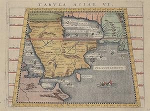
Tabula Asiae VI
Verlag: Artist: Ptolemy/Giovanni Magini Claudius ( - 1617 ) Padua ; ca: 1617; - Giovanni Antonio Magini was an italian astronomer astrologer cartographer and mathematician In 1592 he issued "De Planis Triangulis" by describing the Quadrant Magini also maufactured an atlas of Italy which has been issued by his son in 1620 The moon craterMagnius was named after Magini Claudius Ptolemy ( arround 100- 160 aC) Geographia gives a list of geographic coordinates of spherical longitude and latitude of almost ten thousand point locations on the earth surface as they were known at his times The list is organized in Tabulae which cor- respond to specific regions of the three known continents at that time Africa Asia and Europe Research on Ptolemy?s Geographia, 1555
Anbieter: Antique Sommer& Sapunaru KG, München, Deutschland
Bewertung:
Technic: Copper print; colorit: original colored; condition: Very good, size (in cm): 13 x 16,5; - Map shows total Arabia, partly the red sea and the Persian Gulf.
-

Tabula Asiae VII
Verlag: Artist: Ptolemy/Giovanni Magini Claudius ( - 1617 ) Padua ; ca: 1617; - Giovanni Antonio Magini was an italian astronomer astrologer cartographer and mathematician In 1592 he issued "De Planis Triangulis" by describing the Quadrant Magini also maufactured an atlas of Italy which has been issued by his son in 1620 The moon craterMagnius was named after Magini Claudius Ptolemy ( arround 100- 160 aC) Geographia gives a list of geographic coordinates of spherical longitude and latitude of almost ten thousand point locations on the earth surface as they were known at his times The list is organized in Tabulae which cor- respond to specific regions of the three known continents at that time Africa Asia and Europe Research on Ptolemy?s Geographia, 1555
Anbieter: Antique Sommer& Sapunaru KG, München, Deutschland
Bewertung:
Technic: Copper print; colorit: original colored; condition: Missing part at lower centerfold replaced, size (in cm): 13 x 17; - Map shows the Caspian sea with Persia, Afganistan and Pakistan.
-
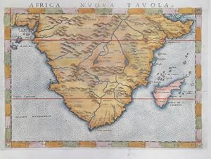
Africa nuova Tavola
Verlag: Artist: Ptolemy/ Ruscelli Claudius ( - 1566 ) ; issued in: Venice ; ca: 1564; - Girolamo Ruscelli (1500s-1566) was an Italian polymath humanist editor and cartographer active in Venice during the early 16th century Ruscelli is best known for his important revision of Ptolemy's Geographia which was published post humously in 1574 It is generally assumed that Alexius Pedemontanus was a pseudonym of Girolamo Ruscelli In a later work Ruscelli reported that the Secreti contained the experimental results of an ?Academy of Secrets? that he and a group of humanists and noblemen founded in Naples in the 1540s Ruscelli?s academy is the first recorded example of an experimental scientific society The academy was later imitated by Giambattista Della Po, 1500
Anbieter: Antique Sommer& Sapunaru KG, München, Deutschland
Bewertung:
Erstausgabe
Technic: Copper print; colorit: original colored; condition: Very good, size (in cm): 18,5 x 25 cm; - Map shows almost all of Africa with Madagascar.; - Special feature: First edition, from the atlas Geographia CL Ptolemaei Alexandrini, latin edition.
-
![Bild des Verkäufers für Tabula Europae VI [Italia]. zum Verkauf von Libreria Oreste Gozzini snc](https://pictures.abebooks.com/inventory/md/md31584031977.jpg)
[In Venetia], [per Gioan. Baptista Pedrezano], [1548], carta geografica raffigurante l'Italia, la Corsica ed altre altre isole vicine all'Italia: incisa in rame, mm. 132x172 (l'impronta della lastra), mm. 167x197 (il foglio, che reca, sull'altra facciata, la descrizione a stampa della carta). Proveniente dall'edizione della Geografia di Tolomeo stampata a Venezia dal Pedrezano nel 1548: in-8, prima edizione con le carte geografiche incise da Giacomo Gastaldi, prima edizione della traduzione italiana di Pietro Andrea Mattioli. "This important edition, printed in a portable format and thus the first to address the needs of travellers, contains the first full series of Ptolemaic maps to appear since the incunable editions of the preceding century. The maps of the present edition were engraved by the prolific Giacomo Gastaldi (c. 1500 - c.1565), cosmographer to the Republic of Venice; while Gastaldi based his engravings of the 26 Ptolemaic maps on the woodcuts by Münster which illustrated the 1540 Basel edition, the 34 modern maps (which are interposed between the ancient maps), were of his own design, and contain significant innovations. [.] The translation by the botanist Pietro Andrea Mattioli appears in this edition only; it was superseded by Girolamo Ruscelli's translation, which was first published in 1561 and frequently reprinted. The only earlier Italian version was Berlinghieri's verse paraphrase (Florence: ca. 1482)". Ottime condizioni.
-
Tabula VIII Asiae ( reverse)
Verlag: Artist: Ptolemy/ Fries Claudius/ Laurent ( Lorenz) ( - 1531 ) Lyon ; issued in: Lyon ; ca: 1535; - Lorenz (Laurent) Fries was born in Alsace in 1490 or thereabouts describing himself on one occasion as from Colmar one of the towns of the region He studied medicine at university or rather at universities as he seems to have had a peripatetic education apparently spending time at the universities of Pavia Piacenza Montpellier and Vienna Having successfully completed his education Fries established himself as a physician at a succession of places in the Alsace region with a short spell in Switzerland before settling in Strasbourg in about 1519 By this time he had established a reputation as a writer on medical topics with several publications, 1490
Anbieter: Antique Sommer& Sapunaru KG, München, Deutschland
Bewertung:
Technic: Copper print; colorit: original colored; condition: Very good, size (in cm): 30,5 x 40,5; - Map shows Mongolia (Antique:Scythie ), Tartarien, Tibet and Indien.
-
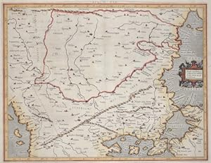
Eur: IX TAB: / Medius meridianus. 51. reliqui ad hune inclinantnr pro ratione. 43. 47. parallelorum.
Verlag: Artist: Ptolemy/ Gerhard Mercator Claudius ( - 1594 ) ; issued in: Duisburg ; ca: 1650; - Gerardus Mercator (1512 - 1594) He was a cartographer philosopher and mathematician He is best known for his work in cartography in particular the world map of 1569 based on a new projection which represented sailing courses of constant bearing as straight lines He is renowned to the present day as the cartographer who created a world map based on a new projection which represented sailing courses of constant bearing as straight lines In his own day he was the world's most famous geographer but in addition he had interests in theology philosophy history mathematics and magnetism as well as being an accomplished engraver calligrapher and maker of globes, 1512
Anbieter: Antique Sommer& Sapunaru KG, München, Deutschland
Bewertung:
Technic: Copper print; colorit: gouache; condition: Some minor restoration at upper centerfold, size (in cm): 35,5 x 45,5; - Map shows the countireis of Romania, Bulgaria, Macedonia and the european part of Turkey with the Bosporus ( partly the asian part of Turkey). With a decorative title cartouche.
-

Tabula Asiae I
Verlag: Artist: Ptolemy/ Ruscelli Claudius ( - 1566 ) ; issued in: Venice ; ca: 1564; - Girolamo Ruscelli (1500s-1566) was an Italian polymath humanist editor and cartographer active in Venice during the early 16th century Ruscelli is best known for his important revision of Ptolemy's Geographia which was published post humously in 1574 It is generally assumed that Alexius Pedemontanus was a pseudonym of Girolamo Ruscelli In a later work Ruscelli reported that the Secreti contained the experimental results of an ?Academy of Secrets? that he and a group of humanists and noblemen founded in Naples in the 1540s Ruscelli?s academy is the first recorded example of an experimental scientific society The academy was later imitated by Giambattista Della Po, 1500
Anbieter: Antique Sommer& Sapunaru KG, München, Deutschland
Bewertung:
Erstausgabe
Technic: Copper print; colorit: original colored; condition: Very good, size (in cm): 18,5 x 25; - Map shows toltal Turkey, map has a trapezoidal projection.; - Special feature: First edition, from the atlas Geographia CL Ptolemaei Alexandrini, latin edition.
-
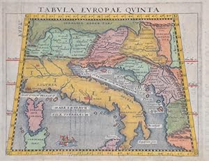
Tabula Europae quinta
Verlag: Artist: Ptolemy/Giovanni Magini Claudius ( - 1617 ) Padua ; ca: 1617; - Giovanni Antonio Magini was an italian astronomer astrologer cartographer and mathematician In 1592 he issued "De Planis Triangulis" by describing the Quadrant Magini also maufactured an atlas of Italy which has been issued by his son in 1620 The moon craterMagnius was named after Magini Claudius Ptolemy ( arround 100- 160 aC) Geographia gives a list of geographic coordinates of spherical longitude and latitude of almost ten thousand point locations on the earth surface as they were known at his times The list is organized in Tabulae which cor- respond to specific regions of the three known continents at that time Africa Asia and Europe Research on Ptolemy?s Geographia, 1555
Anbieter: Antique Sommer& Sapunaru KG, München, Deutschland
Bewertung:
Technic: Copper print; colorit: original colored; condition: Very good, size (in cm): 13 x 16; - Map shows Italy with the Island Corsica, South Germany, Austria, Hungaria, Croatia, Dalmatia and Bosnia.
-

Bohemiae nova descriptio tabula
Verlag: Artist: Ptolemy/Münster Sebastian Claudius ( - 1552 ) Basel ; issued in: Basle ; ca: 1540; - Sebastian Münster (1488 ? 1552) belongs tot he very important Comographers oft he Renaicance He issued his first famous Cosmographia in 1544 with 24 double paged maps with German description of the worldIt had numerous editions in different languages including Latin French Italian English and Czech The last German edition was published in 1628 long after his death The Cosmographia was one of the most successful and popular books of the 16th century It passed through 24 editions in 100 years This success was due to the notable woodcuts some by Hans Holbein the Younger Urs Graf Hans Rudolph Deutsch and David Kandel It was most important in reviving ge, 1489
Anbieter: Antique Sommer& Sapunaru KG, München, Deutschland
Bewertung:
Technic: Woodcut; colorit: original colored; condition: Very good, size (in cm): 27 x 35,5 cm; - Map shows the whole of Bohemia with its sites, rivers, mountains and forests in the Czech Republic.; - Special feature: From the famous Cosmographia, latin edition.
-
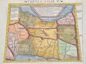
Tabula Asiae V
Verlag: Artist: Ptolemy/Münster Sebastian Claudius ( - 1552 ) Basel ; issued in: Basle ; ca: 1552; - Sebastian Münster (1488 ? 1552) belongs tot he very important Comographers oft he Renaicance He issued his first famous Cosmographia in 1544 with 24 double paged maps with German description of the worldIt had numerous editions in different languages including Latin French Italian English and Czech The last German edition was published in 1628 long after his death The Cosmographia was one of the most successful and popular books of the 16th century It passed through 24 editions in 100 years This success was due to the notable woodcuts some by Hans Holbein the Younger Urs Graf Hans Rudolph Deutsch and David Kandel It was most important in reviving ge, 1489
Anbieter: Antique Sommer& Sapunaru KG, München, Deutschland
Bewertung:
Technic: Woodcut; colorit: original colored; condition: Perfect condition, size (in cm): 26,5 x 34 cm; - Trapezoidal map shows Asia Minor with Persia, the area of __the Tigris and Euphrates rivers, the former Mesopotamia.
-
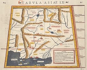
Tabula Asiae IX
Verlag: Artist: Ptolemy/Münster Sebastian Claudius ( - 1552 ) Basel ; issued in: Basle ; ca: 1550; - Sebastian Münster (1488 ? 1552) belongs tot he very important Comographers oft he Renaicance He issued his first famous Cosmographia in 1544 with 24 double paged maps with German description of the worldIt had numerous editions in different languages including Latin French Italian English and Czech The last German edition was published in 1628 long after his death The Cosmographia was one of the most successful and popular books of the 16th century It passed through 24 editions in 100 years This success was due to the notable woodcuts some by Hans Holbein the Younger Urs Graf Hans Rudolph Deutsch and David Kandel It was most important in reviving ge, 1489
Anbieter: Antique Sommer& Sapunaru KG, München, Deutschland
Bewertung:
Technic: Woodcut; colorit: original colored; condition: Very good, size (in cm): 26 x 34 cm; - Map shows Pakistan with the river Indus, Afgansitan and partly Iran.
-
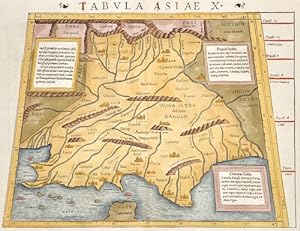
Tabula Asiae X
Verlag: Artist: Ptolemy/Münster Sebastian Claudius ( - 1552 ) Basel ; issued in: Basle ; ca: 1550; - Sebastian Münster (1488 ? 1552) belongs tot he very important Comographers oft he Renaicance He issued his first famous Cosmographia in 1544 with 24 double paged maps with German description of the worldIt had numerous editions in different languages including Latin French Italian English and Czech The last German edition was published in 1628 long after his death The Cosmographia was one of the most successful and popular books of the 16th century It passed through 24 editions in 100 years This success was due to the notable woodcuts some by Hans Holbein the Younger Urs Graf Hans Rudolph Deutsch and David Kandel It was most important in reviving ge, 1489
Anbieter: Antique Sommer& Sapunaru KG, München, Deutschland
Bewertung:
Technic: Woodcut; colorit: colored; condition: Some restoration at centerfold, size (in cm): 26 x 34,5; - Map shows India with the river Ganges, Irak, and Iran. Decorative ornamental title on reverse.
-
Medius meridianus 56, reliqui inclinantur ad hunc ratione 25 et 30 parallorum
Verlag: Artist: Ptolemy/ Gerhard Mercator Claudius ( - 1594 ) ; issued in: Duisburg ; ca: 1578; - Gerardus Mercator (1512 - 1594) He was a cartographer philosopher and mathematician He is best known for his work in cartography in particular the world map of 1569 based on a new projection which represented sailing courses of constant bearing as straight lines He is renowned to the present day as the cartographer who created a world map based on a new projection which represented sailing courses of constant bearing as straight lines In his own day he was the world's most famous geographer but in addition he had interests in theology philosophy history mathematics and magnetism as well as being an accomplished engraver calligrapher and maker of globes, 1512
Anbieter: Antique Sommer& Sapunaru KG, München, Deutschland
Bewertung:
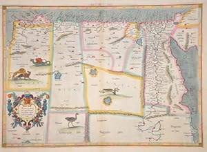
Technic: Copper print; colorit: original colored; condition: Very good, size (in cm): 34,5 x 47,5; - Map shows Egypt and Lybia.
-

Helvetiae Tabula.
Verlag: Artist: Ptolemy/Münster Sebastian Claudius ( - 1552 ) Basel ; issued in: Basle ; ca: 1540; - Sebastian Münster (1488 ? 1552) belongs tot he very important Comographers oft he Renaicance He issued his first famous Cosmographia in 1544 with 24 double paged maps with German description of the worldIt had numerous editions in different languages including Latin French Italian English and Czech The last German edition was published in 1628 long after his death The Cosmographia was one of the most successful and popular books of the 16th century It passed through 24 editions in 100 years This success was due to the notable woodcuts some by Hans Holbein the Younger Urs Graf Hans Rudolph Deutsch and David Kandel It was most important in reviving ge, 1489
Anbieter: Antique Sommer& Sapunaru KG, München, Deutschland
Bewertung:
Technic: Woodcut; colorit: original colored; condition: Perfect condition, size (in cm): 27 x 34,5 cm; - Map shows total Swizzerland and its borgering countries, Germany with the Elsass.; - Special feature: From the famous Cosmographia, latin edition.
-
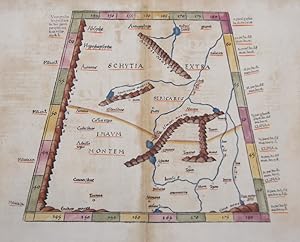
Tab. VII. Asiae exhibens Scythiam, intra Imaum Sogdianam, Bactrianam, Hircaniam.
Verlag: Artist: Ptolemy/ Gerhard Mercator Claudius ( - 1594 ) ; ca: 1578; - Gerardus Mercator (1512 - 1594) He was a cartographer philosopher and mathematician He is best known for his work in cartography in particular the world map of 1569 based on a new projection which represented sailing courses of constant bearing as straight lines He is renowned to the present day as the cartographer who created a world map based on a new projection which represented sailing courses of constant bearing as straight lines In his own day he was the world's most famous geographer but in addition he had interests in theology philosophy history mathematics and magnetism as well as being an accomplished engraver calligrapher and maker of globes and scientific instru, 1512
Anbieter: Antique Sommer& Sapunaru KG, München, Deutschland
Bewertung:
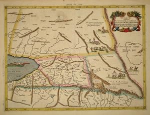
Technic: Copper print; colorit: original colored; condition: Very good, size (in cm): 35 x 46; - Map shows parts of Kazakhstan at the Caspian sea.