
Gesamtpreis (1 Artikel Artikel):
Versandziel:

ptolemy gerhard mercator claudius (9 Ergebnisse)
Direkt zu den wichtigsten Suchergebnissen
Produktart
- Alle Produktarten
- Bücher (9)
- Magazine & Zeitschriften
- Comics
- Noten
- Kunst, Grafik & Poster
- Fotografien
- Karten
-
Manuskripte &
Papierantiquitäten
Zustand
- Alle
- Neu
- Antiquarisch/Gebraucht
Einband
- alle Einbände
- Hardcover
- Softcover
Weitere Eigenschaften
- Erstausgabe
- Signiert
- Schutzumschlag
- Angebotsfoto
Land des Verkäufers
Verkäuferbewertung
-
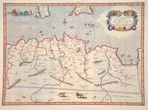
Tab. II Africae, complectens Africam proprie dictam
Verlag: Artist: Ptolemy/ Gerhard Mercator Claudius ( - 1594 ) ; issued in: Duisburg ; ca: 1578; - Gerardus Mercator (1512 - 1594) He was a cartographer philosopher and mathematician He is best known for his work in cartography in particular the world map of 1569 based on a new projection which represented sailing courses of constant bearing as straight lines He is renowned to the present day as the cartographer who created a world map based on a new projection which represented sailing courses of constant bearing as straight lines In his own day he was the world's most famous geographer but in addition he had interests in theology philosophy history mathematics and magnetism as well as being an accomplished engraver calligrapher and maker of globes, 1512
Anbieter: Antique Sommer& Sapunaru KG, München, Deutschland
Bewertung:

Technic: Copper print; colorit: original colored; condition: Very good, size (in cm): 33 x 45; - Map shows total Tunesie with Malta and partly Lybia.
-
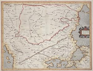
Eur: IX TAB: / Medius meridianus. 51. reliqui ad hune inclinantnr pro ratione. 43. 47. parallelorum.
Verlag: Artist: Ptolemy/ Gerhard Mercator Claudius ( - 1594 ) ; issued in: Duisburg ; ca: 1650; - Gerardus Mercator (1512 - 1594) He was a cartographer philosopher and mathematician He is best known for his work in cartography in particular the world map of 1569 based on a new projection which represented sailing courses of constant bearing as straight lines He is renowned to the present day as the cartographer who created a world map based on a new projection which represented sailing courses of constant bearing as straight lines In his own day he was the world's most famous geographer but in addition he had interests in theology philosophy history mathematics and magnetism as well as being an accomplished engraver calligrapher and maker of globes, 1512
Anbieter: Antique Sommer& Sapunaru KG, München, Deutschland
Bewertung:
Technic: Copper print; colorit: gouache; condition: Some minor restoration at upper centerfold, size (in cm): 35,5 x 45,5; - Map shows the countireis of Romania, Bulgaria, Macedonia and the european part of Turkey with the Bosporus ( partly the asian part of Turkey). With a decorative title cartouche.
-
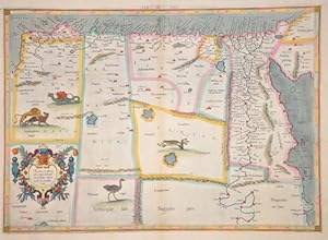
Medius meridianus 56, reliqui inclinantur ad hunc ratione 25 et 30 parallorum
Verlag: Artist: Ptolemy/ Gerhard Mercator Claudius ( - 1594 ) ; issued in: Duisburg ; ca: 1578; - Gerardus Mercator (1512 - 1594) He was a cartographer philosopher and mathematician He is best known for his work in cartography in particular the world map of 1569 based on a new projection which represented sailing courses of constant bearing as straight lines He is renowned to the present day as the cartographer who created a world map based on a new projection which represented sailing courses of constant bearing as straight lines In his own day he was the world's most famous geographer but in addition he had interests in theology philosophy history mathematics and magnetism as well as being an accomplished engraver calligrapher and maker of globes, 1512
Anbieter: Antique Sommer& Sapunaru KG, München, Deutschland
Bewertung:
Technic: Copper print; colorit: original colored; condition: Very good, size (in cm): 34,5 x 47,5; - Map shows Egypt and Lybia.
-
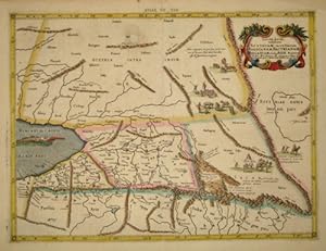
Tab. VII. Asiae exhibens Scythiam, intra Imaum Sogdianam, Bactrianam, Hircaniam.
Verlag: Artist: Ptolemy/ Gerhard Mercator Claudius ( - 1594 ) ; ca: 1578; - Gerardus Mercator (1512 - 1594) He was a cartographer philosopher and mathematician He is best known for his work in cartography in particular the world map of 1569 based on a new projection which represented sailing courses of constant bearing as straight lines He is renowned to the present day as the cartographer who created a world map based on a new projection which represented sailing courses of constant bearing as straight lines In his own day he was the world's most famous geographer but in addition he had interests in theology philosophy history mathematics and magnetism as well as being an accomplished engraver calligrapher and maker of globes and scientific instru, 1512
Anbieter: Antique Sommer& Sapunaru KG, München, Deutschland
Bewertung:
Technic: Copper print; colorit: original colored; condition: Very good, size (in cm): 35 x 46; - Map shows parts of Kazakhstan at the Caspian sea.
-
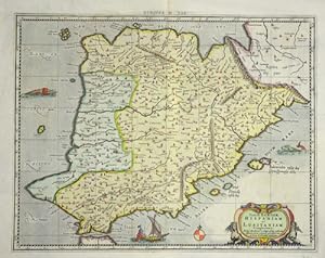
Tab. II. Europae, Hispaniam ac Lusitaniam Complectens.
Verlag: Artist: Ptolemy/ Gerhard Mercator Claudius ( - 1594 ) ; issued in: Duisburg ; ca: 1578; - Gerardus Mercator (1512 - 1594) He was a cartographer philosopher and mathematician He is best known for his work in cartography in particular the world map of 1569 based on a new projection which represented sailing courses of constant bearing as straight lines He is renowned to the present day as the cartographer who created a world map based on a new projection which represented sailing courses of constant bearing as straight lines In his own day he was the world's most famous geographer but in addition he had interests in theology philosophy history mathematics and magnetism as well as being an accomplished engraver calligrapher and maker of globes, 1512
Anbieter: Antique Sommer& Sapunaru KG, München, Deutschland
Bewertung:
Technic: Copper print; colorit: colored; condition: Perfect condition, size (in cm): 34 x 43 cm; - Map shows the Iberian Peninsula with Spain, Portugal, the Balearic Islands and a title cartouche.
-
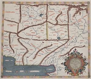
Asiae Tabula IX / Medius meridianus jjj ad quem resiqui inclinantur.
Verlag: Artist: Ptolemy/ Gerhard Mercator Claudius ( - 1594 ) ; issued in: Duisburg ; ca: 1584; - Gerardus Mercator (1512 - 1594) He was a cartographer philosopher and mathematician He is best known for his work in cartography in particular the world map of 1569 based on a new projection which represented sailing courses of constant bearing as straight lines He is renowned to the present day as the cartographer who created a world map based on a new projection which represented sailing courses of constant bearing as straight lines In his own day he was the world's most famous geographer but in addition he had interests in theology philosophy history mathematics and magnetism as well as being an accomplished engraver calligrapher and maker of globes, 1512
Anbieter: Antique Sommer& Sapunaru KG, München, Deutschland
Bewertung:
Technic: Copper print; colorit: original colored; condition: Very good, size (in cm): 34,5 x 39; - Map shows Pakistan with the river Indus, Afgansitan and partly Iran.
-
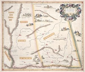
Asiae VIII Tab / Medius meridianus 160, ad quem applicantur reliqui iuxta rationes parallelorum 42 u 54.
Verlag: Artist: Ptolemy/ Gerhard Mercator Claudius ( - 1594 ) ; issued in: Bruxelles ; ca: 1578; - Gerardus Mercator (1512 - 1594) He was a cartographer philosopher and mathematician He is best known for his work in cartography in particular the world map of 1569 based on a new projection which represented sailing courses of constant bearing as straight lines He is renowned to the present day as the cartographer who created a world map based on a new projection which represented sailing courses of constant bearing as straight lines In his own day he was the world's most famous geographer but in addition he had interests in theology philosophy history mathematics and magnetism as well as being an accomplished engraver calligrapher and maker of globe, 1512
Anbieter: Antique Sommer& Sapunaru KG, München, Deutschland
Bewertung:
Technic: Copper print; colorit: original colored; condition: Small tears at the margin restored, little stains and browning, size (in cm): 35 x 40,5 cm; - Decorative map shows a part of China with Mongolia and many decorative representations as tents, hunting scene, cows etc. The rare first issue from Mercator?s definitive edition of Ptolemy?s Geography. This map depicts the area now known as China and Mongolia. Specifically, it shows the lands of Scythia Extra Imaum and Serica. Scythia Extra Imaum refers to the territory of the nomadic Scythians to the east of the Tian Shan mountain range, and the several vignettes within the map illustrate various aspects of nomadic life. Serica was a mysterious land thought to be the source of silk: indeed, the placename literally means ?the land where silk comes from.? Meeting in this map are two of the most important figures in the history of geography. Geographic data and mapmaking instructions left by the Alexandrian, Claudius Ptolemy (fl. A.D. 127-180), became the foundation of mapmaking as we know it today. And it was Gerard Mercator (1512-1594), the great Flemish geographer, whose edition of Ptolemy was considered the most accurate. In particular, Mercator?s maps conformed more closely to Ptolemy?s original design than any of the several earlier editions. Mercator?s became the standard text, with many editions following this one as late as the 18th century. Mercator in 1540 published Literarum latinarum, the first instructional handbook in the use of the italic hand to appear outside of Italy. It was also the first work to offer instruction in the use of italic script in the engraving of maps. The maps in Mercator?s Ptolemy are arguably the finest demonstrations Mercator provided in the use of italics. Moreover, ?the beauty and legibility of the best sixteenth and severteenth-century Dutch maps can be traced in large measure to Mercator?s influence? (Karrow, p. 382).
-
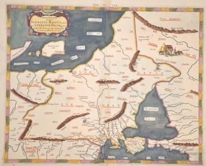
EUR: VIII. TAB:
Verlag: Artist: Ptolemy/ Gerhard Mercator Claudius ( - 1594 ) ; issued in: Duisburg ; ca: 1600; - Gerardus Mercator (1512 - 1594) He was a cartographer philosopher and mathematician He is best known for his work in cartography in particular the world map of 1569 based on a new projection which represented sailing courses of constant bearing as straight lines He is renowned to the present day as the cartographer who created a world map based on a new projection which represented sailing courses of constant bearing as straight lines In his own day he was the world's most famous geographer but in addition he had interests in theology philosophy history mathematics and magnetism as well as being an accomplished engraver calligrapher and maker of globes, 1512
Anbieter: Antique Sommer& Sapunaru KG, München, Deutschland
Bewertung:
Technic: Copper print; colorit: colored; condition: Some minor repairs, size (in cm): 34,5 x 43; - Map depicts the area of Sarmatia, Russia and the Ukrain with the peninsula Krim and the black sea.
-
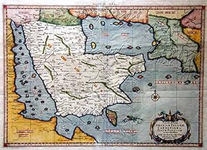
Tab. VI. Asiae Arabiam Felicem. Carmaniam ac. Sinum Persicum comprehendens"
Verlag: Artist: Ptolemy/ Gerhard Mercator Claudius ( - 1594 ) ; ca: 1690; - Gerardus Mercator (1512 - 1594) He was a cartographer philosopher and mathematician He is best known for his work in cartography in particular the world map of 1569 based on a new projection which represented sailing courses of constant bearing as straight lines He is renowned to the present day as the cartographer who created a world map based on a new projection which represented sailing courses of constant bearing as straight lines In his own day he was the world's most famous geographer but in addition he had interests in theology philosophy history mathematics and magnetism as well as being an accomplished engraver calligrapher and maker of globes and scientific instru, 1512
Anbieter: Antique Sommer& Sapunaru KG, München, Deutschland
Bewertung:
Technic: Copper print; colorit: colored; condition: Very good, size (in cm): 34 x 48; - Map of the Arabic Peninsula, the Red Sea and the Persian Gulf.