
Gesamtpreis (1 Artikel Artikel):
Versandziel:

ptolemy petrus turre claudius (4 Ergebnisse)
Direkt zu den wichtigsten Suchergebnissen
Produktart
- Alle Produktarten
- Bücher (3)
- Magazine & Zeitschriften
- Comics
- Noten
- Kunst, Grafik & Poster
- Fotografien
- Karten (1)
-
Manuskripte &
Papierantiquitäten
Zustand
- Alle
- Neu
- Antiquarisch/Gebraucht
Einband
- alle Einbände
- Hardcover
- Softcover
Weitere Eigenschaften
- Erstausgabe
- Signiert
- Schutzumschlag
- Angebotsfoto
Land des Verkäufers
Verkäuferbewertung
-

Quinta Europe tabula
Verlag: Artist: Ptolemy/ Petrus de Turre Claudius ; issued in: Rome ; ca: ; - Petrus de Turre puchased Conrad Sweynheyms plates in 1490 to reissue the maps based on Claudius Ptolemy notes Claudius Ptolemy ( arround 100- 160 aC) Geographia gives a list of geographic coordinates of spherical longitude and latitude of almost ten thousand point locations on the earth surface as they were known at his times The list is organized in Tabulae which cor- respond to specific regions of the three known continents at that time Africa Asia and Europe Research on Ptolemy?s Geographia has started at the University of Thessaloniki Greece in the eighties focused mainly but not exclusively on data re- lated to territories which are now under the sovereignty of the m, 1490
Anbieter: Antique Sommer& Sapunaru KG, München, Deutschland
Bewertung:

Technic: Woodcut; colorit: original colored; condition: Perfect condition, size (in cm): 26,5 x 55 cm; - Map shows north east Italy, Slowenis, Croatia and Dalmatia.; - Special feature: Published in the second edition Ptolomy of Angelus & Caldarini.
-

Septima Asiae Tabula
Verlag: Artist: Ptolemy/ Petrus de Turre Claudius ; issued in: Rome ; ca: ; - Petrus de Turre puchased Conrad Sweynheyms plates in 1490 to reissue the maps based on Claudius Ptolemy notes Claudius Ptolemy ( arround 100- 160 aC) Geographia gives a list of geographic coordinates of spherical longitude and latitude of almost ten thousand point locations on the earth surface as they were known at his times The list is organized in Tabulae which cor- respond to specific regions of the three known continents at that time Africa Asia and Europe Research on Ptolemy?s Geographia has started at the University of Thessaloniki Greece in the eighties focused mainly but not exclusively on data re- lated to territories which are now under the sovereignty of the m, 1490
Anbieter: Antique Sommer& Sapunaru KG, München, Deutschland
Bewertung:
Technic: Woodcut; colorit: original colored; condition: Perfect condition, size (in cm): 30 x 55; - Rare trapezoind projection map of the Caspian Sean with the bordering countries.; - Special feature: After the manuscript of Nicolas Germanus.
-
Secunda Europe Tabula
Verlag: Artist: Ptolemy/ Petrus de Turre Claudius ; issued in: Rome ; ca: ; - Petrus de Turre puchased Conrad Sweynheyms plates in 1490 to reissue the maps based on Claudius Ptolemy notes Claudius Ptolemy ( arround 100- 160 aC) Geographia gives a list of geographic coordinates of spherical longitude and latitude of almost ten thousand point locations on the earth surface as they were known at his times The list is organized in Tabulae which cor- respond to specific regions of the three known continents at that time Africa Asia and Europe Research on Ptolemy?s Geographia has started at the University of Thessaloniki Greece in the eighties focused mainly but not exclusively on data re- lated to territories which are now under the sovereignty of the m, 1490
Anbieter: Antique Sommer& Sapunaru KG, München, Deutschland
Bewertung:
Technic: Woodcut; colorit: black/white; condition: Very good, size (in cm): 34,5 x 54 cm; - Map shows in trapezoidal form the Iberian Peninsula with Spain, Portugal and the Balearic Islands (Mallorca, Menorca, Ibiza).
-
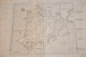
![Bild des Verkäufers für [The Balkans, Austria and Southern Germany]. Quinta Europe Tabula. zum Verkauf von Antiquariat Dasa Pahor GbR](https://pictures.abebooks.com/inventory/md/md15853160875.jpg)
[The Balkans, Austria and Southern Germany]. Quinta Europe Tabula.
Anbieter: Antiquariat Dasa Pahor GbR, München, Deutschland
Bewertung:

Karte
The rare map of the Balkans, Austria and Southern Germany from the 'Rome Ptolemy', a monument in the early history of engraving and the cartography of Central and Southeastern Europe. This exquisitely engraved incunable map is one of the earliest printed maps to focus on what is now Slovenia, Austria, Croatia, Serbia, Montenegro, Macedonia and much of Southern Germany. It depicts the Ancient Roman conception of the region as proscribed by Claudius Ptolemy (c. 150 AD), and while at first not entirely familiar to the modern viewer, upon closer examination, the map takes one on a fascinating historical journey. The map embraces the entire upper Danube Basin, from the river's source in the Black Forest down to a point beyond Belgrade, and gives a detailed rendering of the territory between the Danube and the Alps (in the west) and the river and the Adriatic Sea (in the east). Names of the various Roman provinces are labelled, as are the locations of numerous settlements, some of which occupy the sitecities. Some notable locations include: 'Augusta' (Augsburg), 'Emona' (Ljubljana), 'Tergestum' (Trieste), 'Julio Bona' (Vindobona, modern Vienna), 'Taururum' (modern Belgrade) and 'Salona Colonia' (near modern Split). The Alps, which merge into the Balkans' Dinaric Alps, move across the map in a brilliantly engraved chain. Much of Italy is shown in silhouette, labelling both Ancient Roman cities, such as 'Roma' (Rome) and 'Mediolanum (Milan) and modern cities that were prominent during the time in which present map was published, including 'Venetia' (Venice) and 'Pisa' (Pisa). The story of the creation of the 'Rome Ptolemy' maps is one of the most fascinating and consequential in the history of incunabula. It begins with Konrad Sweynheim, who is widely thought to have been present at the birth of printing while an apprentice to Johann Guttenberg. After Mainz was sacked in 1462, Sweynheim fled to Italy and arrived at the Benedictine monastery of Subiaco, likely and cad with the active support of Cardinal Giovanni of Turrecremata, the Abbot of Subiaco. In 1464-5, Sweynheim, in partnership with another German émigré, Arnold Pannartz, introduced the first printing press to Italy. Over the next few years, Pope Paul II was to become so enthusiastic about the new medium of printing that he liquidated scriptoria and commissioned several newly established printers to publish religious and humanist texts. In 1467, Sweynheim and Pannartz moved to Rome under the Pope's patronage where they issued over fifty books from their press at the Massimi Palace. They are credited for inventing Roman typeface during this period. By 1472, while Sweynheim and Pannartz's accomplishments were impressive, they were not able to sell enough books to sustain their enterprise. Fortunately, the new pope, Sixtus IV stepped in and gave both men ecclesiastical sinecures, which paid the bills. Sweynheim and Pannartz decided to move away from mass ping and to rededicate their efforts to creatine first printed illustrated edition of Claudius Ptolemy's "Geography". Claudius Ptolemy (c. 90 - c. 168 AD) was a Greco-Egyptian scholar who wrote the "Geography" (circa 150 AD), a work that is regarded as the apogee of Greco-Roman geographical knowledge and cartography. The work featured a gazetteer with around 8,000 place names and their corresponding coordinates of latitude and longitude, as well as 27 maps of the known world, including Europe, North Africa and Asia. The present map is the "Quinta Tabula" or 'Fifth Map' of Ptolemy's ten regional maps of Europe. By 1474, the project was well under way, as Swey"mathematicians" to engrave maps on copper. However, the Germans encountered competition from Taddeo Crivelli of Bologna, who was determined to be the first to the goal. Crivelli even allegedly poached one of Sweynheim's employees who possessed sensitive information on the progress of the work going on in Rome. Crivelli raced to complete his project, while Sweynheim painstakingly guided the quality of his work, an endeavour slowed by the death of Pannartz in the plague of 1476. Crivelli's work was finally published on June 29, 1477, making it the first printed edition of the Geography to feature maps. Sweynheim died in 1477, and the work was taken up by Arnold Buckinck, originally from Cologne, who saw the endeavour to its completion on October 10, 1478. While the 'Rome Ptolemy' may not have contained the first printed Ptolemaic maps, the quality of its engraving was absolutely magnificent and dramatically superior to that of the Bologna edition. As Rodney Shirley notes: "The copper plates engraved at Rome . [uperior in clarity and craftsmanship to those of the 1477 Bologna edition . Many consider the Rome plates to be the finest Ptolemaic plates produced until Gerard Mercator engraved his classical world atlas in 1578." (Shirley, p. 3). According to Skelton, Sweynheim's close supervision of his engravers saw that: "The superior craftsmanship of the engraved maps in the Rome edition, by comparison with those of the [1477] Bologna edition, is conspicuous and arresting. The cleanliness and precision with which the geographical details are drawn; the skill with which the elements of the map are arranged according to their significance, and the sensitive use of the burin in working the plates - these qualities . seem to point to the hand of an experienced master, perhaps from North Italy." (Skelton, p. VIII). A number of authorities have suggested that the principal engraver of the Rome Ptolemy's maps came from either Venice or Ferrara. Another aspect of these maps that stands out are theman leed for the place names on the plates. In an apparently unique experiment, these letters were not engraved with a burin but punched into the printing plate using metal stamps or dies. The maps represent a milestone in the medium, being some of the earliest successful intaglio engravings, quite apart from their undeniable cartographic importance. While t.