
Gesamtpreis (1 Artikel Artikel):
Versandziel:

puissant louis (29 Ergebnisse)
Direkt zu den wichtigsten Suchergebnissen
Produktart
- Alle Produktarten
- Bücher (29)
- Magazine & Zeitschriften
- Comics
- Noten
- Kunst, Grafik & Poster
- Fotografien
- Karten
-
Manuskripte &
Papierantiquitäten
Zustand
Einband
Weitere Eigenschaften
- Erstausgabe (7)
- Signiert
- Schutzumschlag
- Angebotsfoto (19)
Gratisversand
Land des Verkäufers
Verkäuferbewertung
-

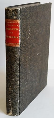
Traité de Topographie, d'Arpentage et de Nivellement. (No planches!)
Verlag: Paris: Courcier, 1820
Erstausgabe
fest gebunden. XXVI S., 1 Bl. Errata, 412 S., 7 Bl. Tableaux des échelles métriques, 14 Bl. Tables Topographiques, 1 Bl. Errata. Halblederband der Zeit (hinterer Buchdeckel lose, vorderes Außengelenk angeplatzt, Rücken mit Fehlstellen, Titelblatt fehlend, es fehlen die Kupfer, Text vollständig). Gr.-8°. 1350 gr.
-

Memoire Sur La Projection de Cassini, Pour Servir de Supplement A Sa Theorie Des
Verlag: HACHETTE LIVRE, 2016
ISBN 10: 2019495945ISBN 13: 9782019495947
Buch
Zustand: New.
-
Traité de Géodésie, Ou Exposition Des Méthodes Trigonométriques Et Astronomiques. Tome 1
Verlag: HACHETTE LIVRE, 2016
ISBN 10: 201369797XISBN 13: 9782013697972
Buch
Zustand: Wie neu. Zustand: Wie neu.
Mehr Angebote von anderen Verkäufern bei ZVAB
Neu ab EUR 37,89
Gebraucht ab EUR 27,44
Mehr entdecken Softcover
-
Traite´ de topographie, d arpentage et de nivellement.
Verlag: British Library, Historical Print Editions, 2012
ISBN 10: 1249003342ISBN 13: 9781249003342
Buch
Zustand: New.
-
Traite de Geodesie, Ou Exposition Des Methodes Trigonometriques Et Astronomiques
Verlag: HACHETTE LIVRE, 2013
ISBN 10: 2013378386ISBN 13: 9782013378383
Buch
Zustand: New. KlappentextrnrnTraite de geodesie, ou Exposition des methodes trigonometriques et astronomiques, applicables soit a la mesure de la terre, soit a la confection des canevas, des cartes et des plans topographiques, par L. Puissant, . 2e edition.
-

Supplément au Traité de Géodésie, contenant de nouvelles Remarques sur plusieurs questions de Géographie mathématique, et sur l'application des Mesures géodésiques et astronomiques ŕ la détermination de la figure de la Terre
Verlag: Bachelier (successeur de M.me V.e Courcier), Paris, 1827
Anbieter: LIBRERIA ANTIQUARIA PIEMONTESE, TORINO, Italien
Bewertung:

In-4°, pp. (4), VIII, 123 + 12 di "Catalogue des livres de fonds, et d'une partie des livres d'assortiment, qui se trouvent a la Librairie Mathématique de Bachelier" aggiornato al luglio 1827, brossura editoriale marmorizzata color rosa pesco con titolo manoscritto al dorso. Le pp. 111-123 sono di tabelle. Ex-libris nobiliare e timbro di appartenenza Scati di Collegno. Bell'esemplare a fogli chiusi. Edizione originale del supplemento scritto dal Puissant (Le Châtelet-en-Brie, 1769-Parigi, 1843) per il proprio importante trattato di geodesia, con cui egli pose le basi della moderna cartografia scientifica. "L'ouvrage que je publie en ce moment offre une collection complčte des méthodes d'observations et de calculs les plus exactes et les plus rigoreuses que les géomčtres aient employées relativement ŕ la mesure de la terre", scrisse il Puissant nell'introduzione alla prima edizione del trattato, risalente al 1805.
-
Traité De Géodésie: Ou, Exposition Des Méthodes Trigonométriques Et Astronomiques, Applicables Ŕ La Mesure De La Terre, Et Ŕ La Constructi
Verlag: WENTWORTH PR, 2018
ISBN 10: 0270231072ISBN 13: 9780270231076
Buch
Zustand: New.
-
PRINCIPES DU FIGURÉ DU TERRAIN ET DU LAVIS: Sur les plans et cartes topographiques, susceptibles de servir de base ŕ l'enseignement du dessin dans les écoles des services publics, et comparaison des différens modes proposés ŕ ce sujet; suivis de nouvelles tables géodésiques relatives a la construction de ces cartes.
Verlag: Libr. Janet et Cotelle. París, 1827, 1827
Anbieter: Libreria Anticuaria Farré, Barcelona, BARCE, Spanien
Bewertung:
. 21 cm. 2 h., III-132 pág., 1 h. y 1 lám. plegada. Ilustr. con tablas en el texto. Enc. en media piel reciente, conserva las cubiertas originales. Puntos de óxido. Marca de caucho.
-
Traite de Topographie, d\ Arpentage Et de Nivellement
Verlag: HACHETTE LIVRE, 2013
ISBN 10: 2012931960ISBN 13: 9782012931961
Buch
Zustand: New.
-

Traité De Géodésie, Ou, Exposition Des Méthodes Trigonométriques Et Astronomiques: Applicables Soit Ŕ La Mesure De La Terre, Soit Ŕ La Confection Des . Topographiques; Volume 2 (French Edition)
Verlag: Legare Street Press, 2022
ISBN 10: 1016960352ISBN 13: 9781016960359
Buch
Gebunden. Zustand: New.
-
Traité De Géodésie: Ou, Exposition Des Méthodes Trigonométriques Et Astronomiques, Applicables Ŕ La Mesure De La Terre, Et Ŕ La Constructi
Verlag: WENTWORTH PR, 2018
ISBN 10: 0270231080ISBN 13: 9780270231083
Buch
Zustand: New.
-
Recueil de diverses propositions de géométrie, résolues ou démontrées par l'analyse algébrique, suivant les principes de Monge et de Lacroix: A l'usage de ceux qui suivent le Traité élémentaire d'application de l'algčbre ŕ la géométrie de ce dernier&
Verlag: de l'Imprimerie de Crapelet,, A Paris,, 1801
Anbieter: Studio Bibliografico Benacense, Riva del garda, Italien
Bewertung:

Erstausgabe
Cm. 21, pp. 121 (7). Con due tavole incise in rame e ripiegate f.t. Leg. coeva in cartoncino d'attesa. Esemplare genuino e marginoso. Prima edizione.
-
Recueil de diverses propositions de géométrie, résolues ou démontrées par l'analyse algébrique, précédé d'un précis du levé des plans. Seconde édition considérablement augmentée.
Verlag: Bernard, librairie de l'Ecole Impériale,, Paris,, 1809
Anbieter: Studio Bibliografico Benacense, Riva del garda, Italien
Bewertung:
Cm. 21,5, pp. xx, 442 (2). Con sei tavole incise in rame e ripiegate f.t. Leg. coeva in cartoncino d'attesa. Esemplare genuino e marginoso, ben conservato.
-
Traité de topographie, d'arpentage et de nivellement&
Verlag: chez Courcier,, A Paris,, 1807
Anbieter: Studio Bibliografico Benacense, Riva del garda, Italien
Bewertung:
Cm. 26, pp. xx, 331 (19). Con 6 tavole incise in rame e ripiegate fuori testo. Solida ed elegante legatura del tempo in mezza pelle, dorso liscio con titoli e filetti in oro. Una riparazione al centro dell'ultima tavola, peraltro esemplare genuino e ben conservato.
-
Traite de geodesie ou exposition des methodes astronomiques et trigonometriques, appliquees soit a la mesure de la terre, soit a la confection des canevas des cartes et des plans. Paris, Courcier 1805 (AN XIV). 4°. XXIV, 319 p., 24 leaves. Contemporary half leather. (rubbed, corners bumped, spine ends slightly damaged, back with tear).- Joints broken, private stamp on flyleaf, title and one page with tear on margin, title and 3 leaves waterstained, throughout slightly wavy, otherwise inside in good condition.
-
Notice sur la nouvelle carte de France suivie de tables, par ordre alphabetique, des noms des prinicipaux points trigonométriques compris dans chacune des feuilles de cette carte.
Verlag: Paris, Ch. Picquet, 1832., 1832
Anbieter: Antiquariat MEINDL & SULZMANN OG, Wien - Vienna, Österreich
Bewertung:
Erstausgabe
4°. 7 SS., 183 nn. Bll. Hldr. d. Zt. mit goldgepr. Rtitel (Ecken u. Kanten etw. bestoßen, gering beschabt, Kapitale mit minimalen Läsuren). Vgl. Poggendorff II, 542.- Erste Ausgabe.- Der französische Geograph und Mathematiker Puissant (1769-1843) hat sich besondere Verdienste um die Erfindung einer neuen Kartenprojektion erworben. Er war Professor für Mathematik an der École Centrale de Lot-et-Garonne, und später an der Militärakademie in Fontainebleau.- Innendeckel mit Bibl.-Schildchen, Titel mit Bibl.-Stempel. Unterschiedlich gebräunt u. stockfleckig, etw. angestaubt. Kartographie, Atlanten.
-
Traite de Géodésie, ou Exposition des Méthodes Trigonométriques et Astronomiques, Applicables a la mesure de la terre, et a la construction du canevas des cartes topographiques.
Verlag: Paris: Bachelier, 1842
Anbieter: Forest Books, ABA-ILAB, Grantham, LINCS, Vereinigtes Königreich
Verbandsmitglied: ABA ILAB PBFA
Bewertung:
Third edition, 4to, 2 vols., in one, xvi, 515, [1]pp., 11 engraved folding plates; xi, [1], 496, xxxii + 24pp., of publishers adverts, 3 engraved plates (first with slight chipping to blank foremargin, cont. calf, lacks spine.
-
Traité de géodesie ou exposition des Méthodes Astronomiques et Trigonométriques, appliquées soit ŕ la mesure de la terre, soit ŕ la confection du canevas des Cartes et des Plans&
Verlag: chez Courcier,, A Paris,, 1805
Anbieter: Studio Bibliografico Benacense, Riva del garda, Italien
Bewertung:
Erstausgabe
Cm. 26, pp. xxiv, 318 (4). Con molte tabelle di geodesia non numerate e 10 tavole nitidamente incise in rame e ripiegate fuori testo. Solida ed elegante legatura del tempo in mezza pelle, dorso liscio con titoli e filetti in oro. Esemplare genuino e ben conservato. Prima edizione.
-
Traité de géodésie, ou exposition des méthodes astronomiques et trigonométriques, appliquées soit ŕ la mesure de la terre, soit ŕ la confection du canevas des cartes et des plans.
Verlag: Courcier, Paris, 1805
Anbieter: Auceps-Antiquariat Sebastian Vogler, Weimar, Deutschland
Bewertung:
Buch
Hardcover. Zustand: Sehr gut. Jean-Baptiste Fosseyeux (illustrator). XXIV, 318 S., [26], X Bl. gef., graph. Darst. (Kupferst.), 1. Ausgabe. Pappbd. d.Zt. mit Kleisterpapier bezogen, goldgepr. Rücken-Titelschildchen, Ecken bestoßen, Papier u. Tafeln tadellos. Poggendorff II, 542.
-
![Bild des Verkäufers für Traité de topographie, d'arpentage et de nivellement [.]. [UNITO A]: Supplement au second livre du traité de topographie, contenant la théorie des projections des cartes. [UNITO A]: Mémoire sur la projection de Cassini pour servir de supplément a sa théorie des projection des cartes géographiques. zum Verkauf von Gabriele Maspero Libri Antichi](https://pictures.abebooks.com/inventory/md/md2688621736.jpg)
Traité de topographie, d'arpentage et de nivellement [.]. [UNITO A]: Supplement au second livre du traité de topographie, contenant la théorie des projections des cartes. [UNITO A]: Mémoire sur la projection de Cassini pour servir de supplément a sa théorie des projection des cartes géographiques.
Verlag: A Paris, chez Courcier, 1807
Anbieter: Gabriele Maspero Libri Antichi, Como, Italien
Bewertung:
Erstausgabe
Zustand: Good. 2 volumi in uno in-4ş (cm. 25,2), legatura in m. pelle (piccoli strappi al dorso); pp. XX, 331, [19] di tabelle e 6 tavole ripiegate f.t.; pp. 112 e 2 tavole ripiegate f.t.; pp 43, [1] in ottimo stato. Prima edizione di quest'opera (1807) e dei suoi supplementi (1810-1812), testi base per gli Ingenieurs-Geographes del Depot general de la guerre, e per le scuole di applicazione del periodo napoleonico. Louis Puissant (1769-1843) pose qui le basi della moderna cartografia scientifica e delle misurazioni astronomiche. Dedicata al principe Alessandro, l'opera espone nella prima parte le teorie fondamentali delle grandi operazioni geodetiche, e nella seconda parte le applicazioni sul terreno e le operazioni grafiche che conducono alla formazione delle carte topografiche. Il Puissant soggiorno' anche in Italia, prima per il tracciamento della posizione geografica e della cartografia dell'Isola d'Elba, e poi, a Milano, per la nuova carta d'Italia. Cfr. NBG XLI, 188-189. Buon esemplare. (SE3).
-
Traité de Topographie, d'arpentage et de nivellement. + Supplément au second livre du Traité de Topographie.
2 volumes in 1. Courcier, Paris 1807-1810. 4to. XX+331+(1)+112 pages. With VII + 1 folding, engraved plates. Contemporary brown halfcalf binding with richly gilt spine. Bookplate on front pastedown. Slight wear to corners.
-
Traite de Topographie, d'Arpentage et de Nivellement
Verlag: Courcier, Paris, 1820
Anbieter: Argosy Book Store, ABAA, ILAB, New York, NY, USA
Bewertung:
hardcover. Second. 9 folding plates. Square 4to, contemporary 1/2 calf, gilt spine; (slight wear to edges of corners), marbled boards. Paris: Courcier, 1820. Second edition. Internally a fine copy. Author was a colonel and surveyor with the French Army in Pyrenees-Orient and Spain beginning in 1792. Later he became a professor of mathematics at several schools including the Military School of Fontainebleau. Brunet 8008.
-
Traité de topographie, d'arpentage et de nivellement
Erscheinungsdatum: 1820
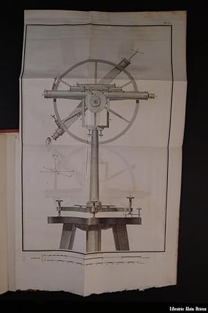
Couverture rigide. Zustand: Bon. de XXVI, (2), 412, (46) pages Paris, Veuve Courcier, 1820, in-4, de XXVI, (2), 412, (46) pages et 9 planches, demi-chagrin, plats de percaline verte estampé ŕ froid et or, trichement dentelles dorées sur les contreplats, Seconde édition de cet ouvrage qui fut imprimé pour la premičre fois en 1807. On y trouve l'une des meilleures théories de la projection des cartes. Louis Puissant (1769-1843) fut, entre autres, professeur de mathématiques ŕ l'Ecole Militaire de Fontainebleau et professeur de Géodésie dans plusieurs écoles d'application. En fin de volume, 9 planches repliés dont certaines représentent des instruments de topographie. Restauration de papier sur la page de titre, sans manque et cachet annulé de l'Institut Catholique de Paris, sinon bon exemplaire bien relié et grand de marges.
-
Traité de géodésie, ou exposition des méthodes astronomiques et trigonométriques, appliquées soit ŕ la mesure de la terre, soit ŕ la confection du canevas des cartes et des plans
Couverture rigide. Zustand: Bon. XXIV, 318, (4), (48) pp., et Paris, Courcier, an XIV-1805, in-4, XXIV, 318, (4), (48) pp, et 10 planches, demi-basane de l'époque, dos lisse orné de filets et fers dorés, pičce de titre en maroquin noir, Premičre édition illustrée de 10 planches repliées. La publication de cet ouvrage fut un événement dans le monde scientifique de l'époque. Louis Puissant réforma les méthodes astronomiques appliquées ŕ la détermination de la mesure de la figure de la terre ; il fut le premier ŕ avoir relevé des erreurs dans la "base du systčme métrique décimal" de Delambre et Méchain. Exemplaire bien complet des 4 feuillets d'errata, des 32 pages des tables géodésiques et des 16 des tables de réfraction de Laplace. Bel exemplaire, trčs grand de marges et ŕ l'intérieur d'une rare fraicheur. Poggendorff II, 542.
-
Traité de géodésie, ou exposition des méthodes trigonométriques et astronomiques applicables ŕ la mesure de la terre et ŕ la construction du canevas des cartes topographiques
Erscheinungsdatum: 1842
Couverture rigide. Zustand: Bon. 2 volumes in-4 de I. XVI, Paris, Bachelier, 1842, , 2 volumes in-4 de I. XVI, 515, (1) pages et 11 planches ; et de II. XI, (1), 496, XXXII pages et 3 planches, pleine basane verte maroquinée de l'époque, Troisičme édition, revue et augmentée par l'auteur. La premičre, parue en 1805, fut un événement dans le monde scientifique de l'époque. Louis Puissant réformait les méthodes astronomiques appliquées ŕ la détermination de la mesure de la figure de la terre ; il était le premier ŕ relever des erreurs dans la "base du systčme métrique décimal" de Delambre et Méchain. Cette nouvelle édition, paru 39 ans aprčs l'édition originale est illustrée de 14 planches repliées représentant de nombreux instruments de géodésie et d'astronomie ainsi qu'une projection de la carte de France. Puissant a été pendant une cinquantaine d'années le représentant le plus éminent de la géodésie française. Rousseurs, cachet annulé de l'Institut Catholique de Paris, sur le verso des pages de titre et des planches, néanmois exemplaire bien relié portant l'ex-libris imprimé d'Henri Viellard.
-
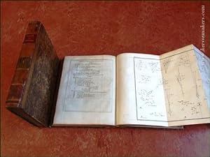
Traité de Topographie, d'arpentage et de nivellement . [and] Supplément au second livre du Traité de Topographie.
Verlag: Chez Courcier, 1807-, Paris, 1810
Anbieter: Hordern House Rare Books, Surry Hills, NSW, Australien
Bewertung:
Erstausgabe
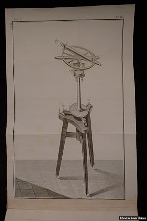
Quarto, two works bound in one, in total seven folding plates and one folding table, some pages age-toned but overall very good, neatly bound in modern quarter calf. A fine volume containing rare first editions of two French works of surveying, said on good authority to be from Phillip Parker King's library. Present here are both Puissant's original Traité of 1807, and the rarer supplement from 1810. Louis Puissant (1768-1843), was born in the Champagne region of France, and learnt geometry as part of his early training as a land-surveyor. First employed in the French war department in 1790, his ability meant that he worked in difficult regions like the Pyrenees and the island of Elba. Early in his career he wrote and published a book on the subject of the shape of the earth, and from 1809 directed the École de Géographes in Paris. He is best remembered for his invention of a new map projection of France, which was produced with considerable detail, using spherical trigonometry, truncated power series and differential geometry. The belief that this is Phillip Parker's King's copy is derived from a note in the hand of the important Australiana collector, Geoffrey C. Ingleton explaining how he bought this work "from a descendant of Phillip Parker King, who owned this book." Given King's renown as a naval officer and hydrographer, his ownership of Puissant's significant study is eminently possible, and certainly the date of its publication tailors neatly with the details of his early career. King, family tradition attests, had been encouraged to pursue a career in hydrography by Matthew Flinders. King had first met Flinders as a child, but the two were reaquainted in 1810, shortly after Flinders return from imprisonment under the French. In turn, in 1811 Flinders introduced him to Sir Joseph Banks. Of course, King's own survey of parts of the Australian coast began in 1817. Ingleton's note also comments that he had the book rebound in 1980. A second enlarged edition was produced in 1820. This first edition with its supplement is scarce: in Australian libraries we have traced only the example in the State Library of NSW. . Provenance: Believed to have been owned by Phillip Parker King; Commander Ingleton (Australian collector, with his illustrated bookplate and a manuscript note).
-
Traité de géodésie, ou exposition des méthodes trigonométriques et astronomiques, applicables soit ŕ la mesure de la terre, soit ŕ la confection des canevas des cartes et des plans topographiques. Deuxičme édition. & Supplément.
Verlag: Paris, V. Courcier.
Anbieter: Emile Kerssemakers ILAB, Heerlen, Niederlande
Bewertung:
1819 - 1827. 3 volumes in 2 bindings. Brown half leather, gilt. Vol. 1: xx,376 pp.: 12 tables and 11 fold. plates. Vol. 2: viii,360 pp.: 19 tables, 2 fold. plates & Vol. 3: Supplément: viii,124 pp.; 27x21 cm. - (spines sl. dam., edges covers rubbed, sl. worn, old convent library stamps, some browning, minor foxing) Although still very good set. See image. 2900g.
-
Traité de Géodésie, ou Exposition des Méthodes Astronomiques et Trigonométriques, appliquées soit ŕ la mesure de la Terre, soit ŕ la confection du canevas des Cartes et des Plans.
Erstausgabe
Paris, Courcier, 1805. 4to. Contemp. Full calf. Gilt spine. Titlelabel with gilt lettering. A paperlabel pasted on top of spine. Stamps on title-page.Corners a bit bumped. Spine slightly rubbed. XXIV,318,( 4 Errata) pp., 16 Tables and 10 large folded engraved plates (apparatus). Wide-margined and clean. First edition. Pouissant is best remembered for his invention of a new map projection for a new map of France, and he was involved in the production of the map. The map was produced with considerable detail, the projection used spherical trigonometry, truncated power series and differential geometry as described here.

![Bild des Verkäufers für Traité de Topographie, d'arpentage et de nivellement . [and] Supplément au second livre du Traité de Topographie. zum Verkauf von Hordern House Rare Books](https://pictures.abebooks.com/inventory/md/md13245438715.jpg)