Gesamtpreis (1 Artikel Artikel):
Versandziel:

rennell james (53 Ergebnisse)
Direkt zu den wichtigsten Suchergebnissen
Produktart
- Alle Produktarten
- Bücher (50)
- Magazine & Zeitschriften
- Comics
- Noten
- Kunst, Grafik & Poster
- Fotografien
- Karten (3)
-
Manuskripte &
Papierantiquitäten
Zustand
Einband
Weitere Eigenschaften
Gratisversand
Land des Verkäufers
Verkäuferbewertung
-
Memoir of a Map of Hindoostan:or the Mogul Empire
Verlag: Bod Third Party Titles 2020-07-13, 2020
ISBN 10: 3337952801ISBN 13: 9783337952808
Buch
paperback. Zustand: New. Language: ENG.
Mehr Angebote von anderen Verkäufern bei ZVAB
Neu ab EUR 50,40
-
Zustand: Wie neu. Zustand: Wie neu | Seiten: 574 | Sprache: Englisch.
Mehr Angebote von anderen Verkäufern bei ZVAB
Gebraucht ab EUR 19,50
-
The Geographical System of Herodotus Examined and Explained, Vol. 2 (Classic Reprint)
Verlag: Forgotten Books, 2015
ISBN 10: 1330348877ISBN 13: 9781330348871
Buch
Zustand: Sehr gut. Zustand: Sehr gut - Gepflegter, sauberer Zustand. | Seiten: 486 | Sprache: Englisch.
-
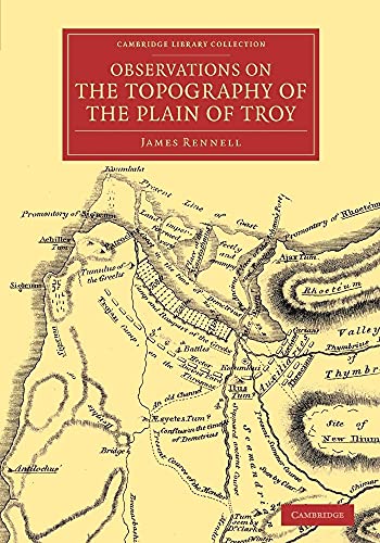
Observations on the Topography of the Plain of Troy : And on the Principal Objects Within, and Around It Described, or Alluded To, in the Iliad
Verlag: Cambridge University Press, 2014
ISBN 10: 1108071821ISBN 13: 9781108071826
Buch
Taschenbuch. Zustand: Neu. Druck auf Anfrage Neuware - Printed after ordering - In this 1814 work, geographer James Rennell compares the topography of the hypothetical site of Troy with ancient accounts.
-
A Treatise On The Comparative Geography Of Western Asia: Accompanied With An Atlas Of Maps Volume 2
Verlag: CHIZINE PUBN, 2018
ISBN 10: 1377012360ISBN 13: 9781377012360
Buch
Zustand: New.
-

A Treatise On the Comparative Geography of Western Asia: Accompanied With an Atlas of Maps
Verlag: CHIZINE PUBN, 2018
ISBN 10: 1377485994ISBN 13: 9781377485997
Buch
Zustand: New.
-

The Geographical System of Herodotus Examined and Explained, by a Comparison With Those of Other Ancient Authors, and With Modern Geography Volume 2
Verlag: SAGWAN PR, 2018
ISBN 10: 1376677679ISBN 13: 9781376677676
Buch
Zustand: New.
-

Memoir of a Map of Hindoostan Or the Mogul\ s Empire: With an Examination of Some Positions in the Former System of Indian Geography and Some Illustr
Verlag: LIGHTNING SOURCE INC, 2016
ISBN 10: 1355748402ISBN 13: 9781355748403
Buch
Gebunden. Zustand: New. KlappentextThis work has been selected by scholars as being culturally important, and is part of the knowledge base of civilization as we know it. This work was reproduced from the original artifact, and remains as true to the original w.
-

A Treatise On the Comparative Geography of Western Asia: Accompanied With an Atlas of Maps, Volume 1
Verlag: LIGHTNING SOURCE INC, 2016
ISBN 10: 1355749506ISBN 13: 9781355749509
Buch
Gebunden. Zustand: New.
-

Treatise on the Comparative Geography of Western Asia - Volume 2
Verlag: Cambridge University Press, 2014
ISBN 10: 1108072119ISBN 13: 9781108072113
Buch
Taschenbuch. Zustand: Neu. Druck auf Anfrage Neuware - Printed after ordering - This 1831 two-volume work surveys an area from Egypt to the Danube and from the Aegean to the Caspian Sea.
-

Memoir of a Map of Hindoostan: Or the Mogul Empire: With an Introduction, Illustrative of the Geography and Present Division of That Country: . by
Verlag: LIGHTNING SOURCE INC, 2016
ISBN 10: 1357799438ISBN 13: 9781357799434
Buch
Gebunden. Zustand: New. KlappentextThis work has been selected by scholars as being culturally important, and is part of the knowledge base of civilization as we know it. This work was reproduced from the original artifact, and remains as true to the original w.
-

The Geographical System of Herodotus Examined and Explained, by a Comparison With Those of Other Ancient Authors, and With Modern Geography Volume 2
Verlag: SWING, 2015
ISBN 10: 1298897599ISBN 13: 9781298897596
Buch
Gebunden. Zustand: New. KlappentextThis work has been selected by scholars as being culturally important, and is part of the knowledge base of civilization as we know it. This work was reproduced from the original artifact, and remains as true to the original w.
-
Treatise on the Comparative Geography of Western Asia - Volume 1
Verlag: Cambridge University Press, 2014
ISBN 10: 1108072100ISBN 13: 9781108072106
Buch
Taschenbuch. Zustand: Neu. Druck auf Anfrage Neuware - Printed after ordering - This 1831 two-volume work surveys an area from Egypt to the Danube and from the Aegean to the Caspian Sea.
-
Memoir Of A Map Of Hindoostan, Or The Mogul Empire
Verlag: ARKOSE PR, 2015
ISBN 10: 134502066XISBN 13: 9781345020663
Buch
Gebunden. Zustand: New. KlappentextThis work has been selected by scholars as being culturally important, and is part of the knowledge base of civilization as we know it. This work was reproduced from the original artifact, and remains as true to the original w.
-
War with France. The only Security of Britain, at the Present Momentous Crisis: Set forth in an earnest address to his fellow-subjects, by an old Englishman.
Verlag: London: Sold by Chapman and Co, 1794
Anbieter: Forest Books, ABA-ILAB, Grantham, LINCS, Vereinigtes Königreich
Verbandsmitglied: ABA ILAB PBFA
Bewertung:

8vo (185 x 125), 16pp., title a little stained, later blue wrappers. The scarcer of the two editions published in the same year (ESTC T52232).
-
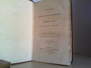
TREATISE ON THE COMPARATIVE GEOGRAPHY OF WESTERN ASIA. Vol. I.
Verlag: Rivington. London., 1831
Buch
hardcover. 390 pages. Leinen, Einband mit zeittypischen Läsuren (berieben, bestossen), sonst guter, sauberer Zustand, good condition, ENGLISH. Sprache: Englisch Gewicht in Gramm: 600.
-
![Bild des Verkäufers für A Map of Bengal, Bahar, Oude & Allahabad: with part of Agra and Delhi, exhibiting the course of the Ganges from Hurdwar to the sea. [Western Half] zum Verkauf von Kaaterskill Books, ABAA/ILAB](https://pictures.abebooks.com/inventory/md/md16350719272.jpg)
A Map of Bengal, Bahar, Oude & Allahabad: with part of Agra and Delhi, exhibiting the course of the Ganges from Hurdwar to the sea. [Western Half]
Verlag: Jas Wyld, (Successor to Mr. Faden) geographer to the King, & H.R.H the Duke of York. Charing Cross, London, 1824
Anbieter: Kaaterskill Books, ABAA/ILAB, East Jewett, NY, USA
Verbandsmitglied: ABAA ILAB IOBA
Bewertung:

Handed colored double page map. 52 x 72 cm. (sheet size: 58 x 80 cm). From James Wyld: "A General Atlas of Modern Geography: consisting of a complete collection of the most approved maps." Map of part of India. Cartouche shows a bearded sea god resting his arm on a bull's head, and an alligator and leopard are beside him. At right, an Indian woman holds a bowl over a kneeling man, as two other men look on. A very good copy, a few marginal stains and tears, some offsetting from facing page.
-

The Route of Mr Mungo Park, from Pisania on the River Gambia, to Silla, on the River Joliba, or Niger; With his return by the Southern Route, to Pisania. Compiled from Mr Park's Observations, Notes, & Sketches.
Erscheinungsdatum: 1798
Anbieter: Altea Antique Maps, London, Vereinigtes Königreich
Verbandsmitglied: ABA ILAB PBFA
Bewertung:
Karte
London: James Rennell, 1798. Some original outline colour. 255 x 660mm. Top edge slightly trimmed for binding, new margin added. The official map of the route of the Scottish explorer Mungo Park (1774-1806) in search of the Niger, here published in his 'Travels in the Interior Districts of Africa'. Under the patronage of Sir Joseph Banks and the African Association, Park travelled to Africa to seek the source of the River Niger (1795-7). His expedition was delayed by captivity and illness (he spent seven months convalescing in a man's home), and he was believed dead when he returned to Britain. Park had little experience as a cartographer, so the job of compiling the maps for the official account fell to Major James Rennell, former cartographer to the East India Company in Bengal. He too had fallen foul of locals and had to retire from active service because of the wounds he had received. He became a research cartographer, becoming a pioneer of oceanography. He used a variety of sources to compile this map and in doing so made his greatest cartographic error: he extrapolated a single mountain seen by Park into a huge range, creating the 'Mountains of Kong', which blighted maps of West Africa for most of the nineteenth century. Here they are referred to in a note 'A Chain of Great Mountains extends along these Parallels'.
-
hardcover. 535, 472 pages. 2 voulmes, complete. alle Tafeln vorhanden. Leinen, Einband mit kleinen Läsuren der Zeit (fleckig, bestossen), Bd. 1: Bindung etwas gelockert, Innen: für Alter guter bis sehr guter Zustand, Karten alle vorhanden. ENGLISH. with guarded portrait frontispiece of the author and eleven large folding copperplate maps of the known World. Sprache: Englisch Gewicht in Gramm: 1800.
-
Description historique et géographique de l'Indostan, traduite de l'anglais par J.B. Bouscheseiche, sur la septičme et derničre édition, ŕ laquelle on a joint des Mélanges d'Histoire et de Statistique sur l'Inde, traduits par J. Castéra
Verlag: De l'imprimerie de Poignée, 1800
Buch Erstausgabe
Couverture rigide. - De l'imprimerie de Poignée, ŕ Paris 1800 - An VIII, 3 tomes en 3 Vol. in 8 (12,5x20,5cm), xxxviij, 299pp. (2), relié. - Edition originale française, rare, traduite par Bouscheseiche. Sans l'atlas contenant 11 cartes que l'on trouve souvent séparément. Reliure en demi veau vert marbré postérieur ca 1850 ; beau pastiche confondant d'une reliure d'époque. Dos lisse orné de grecques et de quatre fleurons. Pičces de titre et de tomaison en maroquin marron. Tranches marbrées. Un manque en queue du tome 2, se poursuivant sur le plat. Bel exemplaire, trčs élégant, et bien frais dans l'ensemble. L'Insdostan s'étendait de l'Himalaya au Nord, jusqu'ŕ la presqu'île de Malabar et de Coromandel au Sud, c'est-ŕ-dire la majeure partie de l'Inde ŕ cette époque. L'étude de James Rennel est presque exclusivement géographique, et seul un chapitre sur la chute du grand Mogol sacrifie ŕ l'aspect historique exception pour l'introduction au tome premier sur l'origine de L'Indostan et les conquętes européennes. L'ouvrage fut trčs bien accueilli en Angleterre, Rennel fournissait assurément des renseignements précis et utiles ŕ quiconque se rendait dans ces contrées. Afin de compléter la géographie physique et humaine de l'Indostan, l'édition française a ajouté plusieurs chapitres, une introduction de textes traduits par Castera sur l'histoire de l'Inde, la bibliographie des voyageurs, et qui forment une grande partie du troisičme volume ; on relčvera avec intéręt le Voyage au Thibet de Samuel Turner. [ENGLISH DESCRIPTION ON DEMAND] xxxviij, 299pp. (2).
-
The geographical system of Herodotus, examined, and explained, by a comparison with those of other ancient authors, and with modern geography . The whole explained by eleven maps .
Verlag: London, W. Bulmer and Co. for G. and W. Nicol, 1800., 1800
Anbieter: Bernard Quaritch Ltd ABA ILAB, London, Vereinigtes Königreich
Verbandsmitglied: ABA ILAB PBFA
Bewertung:
Erstausgabe Signiert
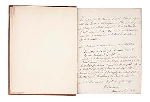
Large 4to, pp. xx, 766, [2]; with engraved frontispiece of the author and 11 engraved maps (all but one folding); short closed marginal tears to a few maps, a little fraying to edge of fifth map, paper repair to blank corner of 4Z3, slight browning, light foxing to plates; overall very good in contemporary calf, rebacked with remains of gilt spine laid down, red morocco lettering-piece; spine and extremities somewhat worn, some abrasions to covers; gilt arms of Harrow School to covers, book label to front pastedown, page of MS notes regarding this and other volumes signed 'Wm Oxenham Harrow Sept 1837' tipped in.First edition of this work on ancient geography by the eminent cartographer James Rennell (1742-1830), 'a monument of laborious research and acute and lucid criticism' (DNB). Best known for his pioneering mapping of India and Africa, Rennell was elected a fellow of the Royal Society in 1781, receiving its Copley medal ten years later.The excellent maps engraved by J. Walker depict, inter alia, 'The world according to the idea of Herodotus', western Scythia, bridges over the Hellespont and Bosphorus, ancient Babylon, lower Egypt, changes in the course of the Nile, the coast and interior of Libya, currents and trade winds in the Atlantic and around Africa, and the voyage of Hanno the Navigator.Provenance: according to a page of manuscript notes tipped in, this volume was purchased for Harrow School Library in 1837, together with other books, by the Rev. William Oxenham, Assistant Master, from a subscription collected by Edward Dugdale Bucknall Estcourt (later of Balliol College, Oxford).ESTC T147321.
-

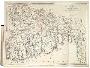
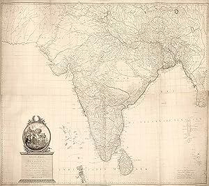
A Map of Bengal, Bahar, Oude & Allahabad with Part of Agra and Delhi Exhibiting the Course of the Ganges from the Hurdwar to the Sea.
Verlag: London Pritned for William Faden Geographer to the King, 1786
Anbieter: Shapero Rare Books, London, Vereinigtes Königreich
Verbandsmitglied: ABA ILAB PBFA
Bewertung:
Karte
Large engraved map on two conjoined sheets, with original hand-colouring; scale approx. 1:1,827,000 (miles); size: 71.5 cm by 106.5 cm, sheet size: 76.5 cm by 115 cm. Mounted: 90.5 cm by 124 cm. A large hand-coloured map showing the course of the Ganges across north-east India from present-day Bangladesh to New Delhi, with the territory of the Bengal Presidency highlighted in pink, and the Indian princely states shown in yellow. The title contained in a cartouche depicting Ganges seated with yak, crocodile and leopard under palm trees, a blessing ceremony in the foreground. Major James Rennell, FRS, FRSE, FRGS (1742-1830) was an East India Company officer, geographer, and pioneer of oceanography. As Surveyor General of Bengal, he produced the first accurate maps of the region and outlines of the Indian subcontinent. Rennell had earlier been tasked with surveying the river Ganges to find the shortest perennially navigable route to the Hooghly River and Calcutta avoirding hte Murshidabad shallows. Dedicated 'To John Stables Esq. One of the Supreme Council of Bengal This Map, Engraved from the Original Drawing on the same Scale in the Possession of the Hon[ora]ble East India Company (communicated to him by the late Mr Dury) is respectfully Inscribed by His obliged and Obedient Servant Will[ia]m Faden'. BMC Cartographic Items Maps K.Top.115.29.2 TAB.
-
Observations on the Topography of the Plain of Troy And on the Principal Objects Within, and Around It Described, Or Alluded To, In the Iliad. That the System of M. De Chevalier, so long upheld, is founded on a most ERRONEOUS TYPOGRAPHY. And also, that the Two Sources, denominated the Warm, and the Cold, Spring, on which his System materially rests, Do Not Present Any Contrast; but are Exactly Alike, In Point of Tempature; that is, Cold. With a map. In Which the Topgraphy Set Forth by M. De Chevalier, is contrated with the several Statements of Three other Travellers in the Troad. Also, a Sketch of the Western Part of the Region of Mount Ida.
Verlag: Printed by W. Bulmer and Co, London, 1814
Anbieter: Heritage Book Shop, ABAA, Beverly Hills, CA, USA
Bewertung:
Erstausgabe
First edition. Quarto. [i-v] vi-xxii, [1, blank], 156, [fold-out map] pp. (Measures 11 1/4 x 8 1/2 inches). Full black morocco., gilt-stamped spine with five raised bands. All edges gilt. Previous owner's bookplate. The slightest of wear to spine extremities, otherwise, near fine. HBS 66802. $2,000.
-
THE GEOGRAPHICAL SYSTEM OF HERODOTUS, EXAMINED; AND EXPLAINED, By a Comparison With Those of Other Ancient Authors, and With Modern Geography.
Verlag: London: Printed by W. Bulmer and Co., 1800
Anbieter: LUCIUS BOOKS (ABA, ILAB, PBFA), York, Vereinigtes Königreich
Verbandsmitglied: ABA ILAB PBFA
Bewertung:
Erstausgabe
First edition. 4to. Handsomely bound in full nineteenth-century blue calf with gilt decorative borders to the upper and lower boards. The spine with four raised bands, gilt titles, and compartments richly decorated in gilt. Marbling to page edges and endpapers. Illustrated with an engraved portrait frontispiece and 11 engraved maps (all but one folding). A near-fine copy, the binding square, firm and bright with a little rubbing and scuffing to the boards and bumping to the corners. The contents with the small gilt armorial ownership label of Granville Hastings Wheler to the front pastedown, contemporary neat ink stamp for the same to the head of the title page, scattered toning and faint spotting, a crease to the corner of three text pages (one with a small marginal tear), and with one map with a few creases, a small marginal tear and standing a little proud of the text block, are otherwise unusually clean and fresh. The other maps remain in excellent condition, with just a minor crease to one, and a little creasing to the margins of two others. A superb copy of Rennell's important work on ancient geography - "a monument of laborious research and acute and lucid criticism" - which attempted to reconcile ancient geographical knowledge with modern discoveries (ODNB). The work is perhaps most famous for its series of attractive and finely detailed maps of the Near East, the Mediterranean and Africa by John Walker, engraver to the Admiralty. These include two maps of the world according to Herodotus, maps of Western Scythia, Hellespont, Bosporus, Babylon, Egypt, Memphis, Libya, the circumnavigation of Africa by the Egyptians under Pharaoh Necho II (610-595 BC), and the voyage of Hanno the Navigator (500 BC), a major voyage of discovery in west Africa and one of the earliest voyages to traverse the Pillars of Hercules in an attempt to extend maritime discovery beyond the Mediterranean. James Rennell (1742-1830) was one of the foremost cartographers of his generation and a key pioneer of oceanography. After spending several years conducting an ambitious and extensive mapping project for the East India Company in Bengal and other parts of the Indian subcontinent, Rennell returned to England and dedicated himself to historical and cartographical scholarship. Elected to the Royal Society in 1781, he was awarded their prestigious Copley Medal ten years later (previously awarded to Captain Cook in 1776 for his study on the alleviation of scurvy), and in 1830 became one of the founding members of the Royal Geographical Society. Further details and images for any of the items listed are available on request. Lucius Books welcomes direct contact with our customers.
-
Neueste Karte von Hindostan Bengalen etc. etc. Mit der Anzeige der Strassen, Paesse, und genauster Eitheilung der britschen Besitzungen in Ostindien Verfusst von Jakob Rennell Ingenieur Major.
Erscheinungsdatum: 1788
Anbieter: Altea Antique Maps, London, Vereinigtes Königreich
Verbandsmitglied: ABA ILAB PBFA
Bewertung:
Karte
Vienna: F.A. Schraemble, 1788. Original outline colour. Four sheets conjoined, total 1190 x 1460mm. Minor repairs to binding folds. A huge map of India, based on Robert Sayer's four-sheet enlarged version of James Rennell's landmark map of India of 1782, but reintroducing the original's decorative vignette of Britannia receiving a 'Shaster' ('Shastra', a Hindu book of rules). Beginning in 1764, James Rennell (1742-1830) surveyed Bengal for the East India Company under the patronage of Robert Clive & Warren Hastings, with a particular focus on the rivers, so important to trade in the absence of a regular road system, especially in the approaches to Calcutta. After over a decade of work Rennell was forced to retire, having been seriously wounded in 1766, and retired to England, where he started work on his 'atlas'. The quality of his work was such that when it was first published in 1780 (not 1779 as is often quoted because of the date on the maps) it earned him a fellowship of the Royal Society (1781) and the sobriquet 'the father of Indian cartography'.
-
India.- A Bengal Atlas: containing Maps of the War and Commerce on that side of Hindoostan
Erscheinungsdatum: 1781
Anbieter: Alexandre Antique Prints, Maps & Books, Toronto, ON, Kanada
Bewertung:

Zustand: A very good example. Edition : Second edition, Recent half red morocco over marbled boards, spine elaborately gilt. , James Rennell: The Father of the Indian Survey Major James Rennell (1742-1830) , received training on surveying in the Royal Navy, joined the East India Company in 1763, was the first Surveyor General of Bengal (1767-1777), and carried out the first comprehensive geographical survey of much of India. The survey was a massive undertaking that mapped parts of India at a greater detail than many European countries had been mapped (Goss, p. 246). His survey led to The Great Trigonometrical Survey of India which began in 1802 (See the exhibit section: "The Survey of India"). He is most known for his Bengal Atlas of 1779 and Memoir of a Map of Hindoostan (1782). Renell continually updated his maps for accuracy and added new geographical information, using indigenous maps and drawings as sources for his maps of the Punjab region. His cartographic methods included gleaning information from earlier maps, measuring distances along roads, establishing the coordinates of control points, and then creating a ?graticule? or grid to create his maps (Edney, p.17-8). Rennell?s maps were of such accuracy and quality that they were used well into the 19th century. Rennell returned to England in 1782 where he continued to write and publish works on geography, history, and became an expert in the mapping and study of ocean currents. , Size : Folio 480mmx 345mm, Letterpress title and contents leaf, engraved index map, double-page view and 23 (numbered 29) maps, all but one double-page, some also folding, the first ten with outline hand-colouring, with a further 3 maps of Hindostan by Rennell on 8 double-page and/or folding engraved sheets bound in at end, all with outline hand-colouring, some with cartouches, additional maps added to list of contents in manuscript, all mounted on stubs.The 3 additional engraved maps by Rennell bound in are: Map of Bengal, Bahar, Oude and Allahabad, 1786 (2 sheets); General Map of Hindoostan, 1782 (2 sheets); General Map of Hindoostan, 1788 (4 sheets). , References : Shirley, British Library T.RENN.
-
A Bengal Atlas: Containing Maps of the Theatre of War and Commerce on that side of Hindoostan. Compiled from the Original Surveys; and published by Order of the Honorable The Court of Directors for the Affairs of the East India Company, By James Rennell, Late Major of Engineers, and Surveyor General in Bengal.
Erscheinungsdatum: 1780
Anbieter: Altea Antique Maps, London, Vereinigtes Königreich
Verbandsmitglied: ABA ILAB PBFA
Bewertung:
London: James Rennell, 1780. Folio, full calf gilt, with red morocco title label; pp. 8; engr. index map (with title & key), map on eight folding sheets with outline colour; and five further maps, all dated 1779. An important series of maps of Bengal, surveyed by James Rennell (1742-1830) for the East India Company under the patronage of Robert Clive & Warren Hastings. He began the first survey of Bengal in 1764, with a particular focus on the rivers, so important to trade in the absence of a regular road system, especially in the approaches to Calcutta. After over a decade of work he was forced to retire, having been seriously wounded in 1766, and retired to England, where he started work on his 'atlas'. The quality of his work was such that when it was first published in 1780 (not 1779 as is often quoted because of the date on the maps) it earned him a fellowship of the Royal Society (1781) and the sobriquet 'the father of Indian cartography'. SHIRLEY: Maps in the Atlases of the British Library T.Renn-1a.
-
Social and Diplomatic Memories 1902-1919
Verlag: Edward Arnold, 1925
Anbieter: World of Rare Books, Goring-by-Sea, SXW, Vereinigtes Königreich
Bewertung:
Zustand: Good. 1925. 401 pages. No dust jacket. Red cloth with gilt lettering. Pages are moderately tanned and thumbed at the edges, with moderate foxing. Binding has remained firm. Boards are a little rub worn with slight shelf wear to corners, spine and edges. Corners are a little bumped. Spine ends are a mildly crushed, with small splits and chips. Tanning to spine and edges. Boards are bowed. Book has a forward lean. Water marks to boards and spine.
-
MASTER KEY: The History of the Madisonville First Baptist Church, Madisonville, KY 1870-1976
Erscheinungsdatum: 1976
Buch Erstausgabe
Hardcover. Zustand: Very Good+. Zustand des Schutzumschlags: Good. Presumed First Edition. Red cloth hardback with a little foxing to the upper edge and a bit to the top of the foredge, otherwise book has practically no wear. The dustjacket has no chips or tears, but there is light sun fading to the spine, and some scattered foxing. Jacket now protected by a clear mylar sleeve. In addition to a history of the church, this volume includes a church roll from 1870-1976, as well as information on each Pastor and Deacon. A wonderful genealogical reference. 302pp.
-

Frederic III Le Prince Heritier l\ Empereur Esquisse Biographique
Verlag: HACHETTE LIVRE, 2015
ISBN 10: 2011916569ISBN 13: 9782011916563
Buch
Zustand: New.