Gesamtpreis (1 Artikel Artikel):
Versandziel:

seller john (38 Ergebnisse)
Direkt zu den wichtigsten Suchergebnissen
Produktart
- Alle Produktarten
- Bücher (27)
- Magazine & Zeitschriften
- Comics
- Noten
- Kunst, Grafik & Poster
- Fotografien
- Karten (9)
-
Manuskripte &
Papierantiquitäten (2)
Zustand
Einband
Weitere Eigenschaften
- Erstausgabe (1)
- Signiert (1)
- Schutzumschlag
- Angebotsfoto (36)
Land des Verkäufers
Verkäuferbewertung
-
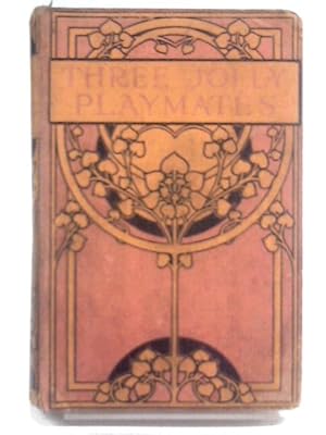
Three Jolly Playmates
Verlag: Charles H. Kelly, 1911
Anbieter: World of Rare Books, Goring-by-Sea, SXW, Vereinigtes Königreich
Bewertung:

Erstausgabe
Zustand: Fair. 1911. First Edition. 181 pages. No dust jacket. Decorated salmon pink cloth covered boards. Pages have mild tanning and foxing throughout, moderate at end-papers, paste-downs and text-block edges. Some occasional mild cracking to gutters throughout however binding remains reasonably firm. Moderate damp staining to paste downs and end papers. Ex Libris plate to front pastedown. Boards have moderate edge-wear with bumping to corners and rubbing to surfaces. Cloth has minor damp and dust stains. Mild crushing to spine ends. Sunning to spine. Minor fraying to cloth at spine ends.
-
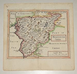
ORIGINAL ENGRAVED MAP OF Merionethshire. North Wales
Verlag: Published Francis Grose 1785-90, 1785
Anbieter: PROCTOR / THE ANTIQUE MAP & BOOKSHOP, DORCHESTER, Vereinigtes Königreich
Verbandsmitglied: PBFA
Bewertung:
Karte
Small detailed engraved map SIZE 6.5 x 5 inches In good condition. A little darkened on edges. Antique engraved map with hand colouring.
-
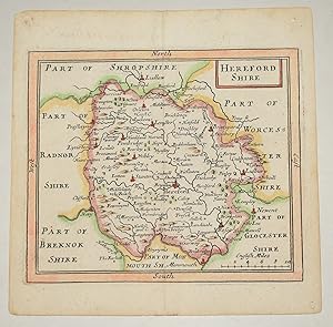
ORIGINAL ENGRAVED MAP OF Herefordshire. English County Map.
Verlag: Published Francis Grose 1785-90, 1785
Anbieter: PROCTOR / THE ANTIQUE MAP & BOOKSHOP, DORCHESTER, Vereinigtes Königreich
Verbandsmitglied: PBFA
Bewertung:
Karte
Small detailed engraved map SIZE 6.5 x 5 inches In very good condition. A little darkened on edges. Antique engraved map with hand colouring.
-
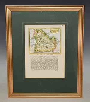
Map of Brecknockshire. Original Antique Engraved Hand Coloured Map. With Description of County. Double Sided.
Verlag: John Seller, ca1780, 1780
Anbieter: PROCTOR / THE ANTIQUE MAP & BOOKSHOP, DORCHESTER, Vereinigtes Königreich
Verbandsmitglied: PBFA
Bewertung:
Framed size approx 17 x 14 inches. Engraved panel approx 9 x 7 inches. (Map approx 6 x 5 inches) Mounted and framed. Double-sided glass with window in rear. In very good condition. Lovely bright colouring. Good strong impression. One tiny dark spot/mark at top right corner. Else a lovely clean map. Original hand coloured engraved map. with description on front and rear. From ?Grose?s Antiquities of England and Wales.?.
-
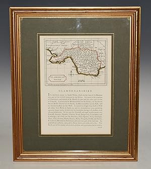
Map of Glamorganshire. Original Antique Engraved Hand Coloured Map. With Description of County. Double Sided.
Verlag: John Seller, ca1780, 1780
Anbieter: PROCTOR / THE ANTIQUE MAP & BOOKSHOP, DORCHESTER, Vereinigtes Königreich
Verbandsmitglied: PBFA
Bewertung:
Framed size approx 17 x 14 inches. Engraved panel approx 9 x 7 inches. (Map approx 6 x 5 inches) Mounted and framed. Double-sided glass with window in rear. In very good condition. Lovely neat colouring. Good strong impression. Else a lovely clean map. Original hand coloured engraved map. with description on front and rear. From ?Grose?s Antiquities of England and Wales.?.
-
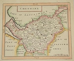
ORIGINAL ENGRAVED MAP OF Cheshire English County Map, with description below.
Verlag: Published Francis Grose 1785-90, 1785
Anbieter: PROCTOR / THE ANTIQUE MAP & BOOKSHOP, DORCHESTER, Vereinigtes Königreich
Verbandsmitglied: PBFA
Bewertung:
Karte
Small detailed engraved map SIZE 6.5 x 5 inches Total Size 10.5 x 6.5 inches In very good condition. Antique engraved map with hand colouring.
-

A new Systeme of Geography: Designed in a Most Plain and Easie Method, for the Better Understanding of That Science: Accommodated With new Maps, o
Verlag: CHIZINE PUBN, 2018
ISBN 10: 1379148898ISBN 13: 9781379148890
Buch
Zustand: New.
-

Practical Navigation Or an Introduction to the Whole Art, . by John Seller, .
Verlag: Gale Ecco, Print Editions, 2010
ISBN 10: 1170043801ISBN 13: 9781170043806
Buch
Zustand: New.
-

A new Systeme of Geography: Designed in a Most Plain and Easie Method, for the Better Understanding of That Science: Accommodated With new Maps, o
Verlag: LIGHTNING SOURCE INC, 2015
ISBN 10: 1342259513ISBN 13: 9781342259516
Buch
Gebunden. Zustand: New.
-
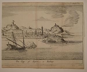
The City of Algiers in Barbary
Verlag: London, 1690
Anbieter: Argosy Book Store, ABAA, ILAB, New York, NY, USA
Bewertung:
unbound. Zustand: very good. View. Uncolored etching. Image measures 4 5/8" x 7 1/16". Charming panoramic view of the port of Algiers, circa 1690. The harbor view shows several ships as well as buildings and hills in the background. John Seller (c. 1630-1697) was an English instrument maker and cartographer and in 1671 he was appointed Hydrographer to the King. Seller instigated the first English maritime atlas, in an effort to compete with the successful Dutch maps at the time. This print was published in "A New Systeme of Geography.", circa 1690. A light crease and toning along the center indicates original folds. Margins cropped, left border missing from original binding.
-
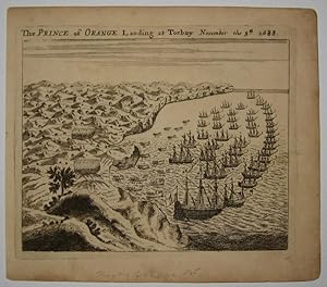
The Prince of Orange Landing at Torbay November 5th 1688
Verlag: London
Anbieter: Argosy Book Store, ABAA, ILAB, New York, NY, USA
Bewertung:
unbound. Zustand: very good. View. Uncolored engraving. Plate measures 4 11/16" x 5 7/8". View of William of Orange arriving at the English coast at Torbay in his claim for the British crown. John Seller (c. 1630-1697) was an English instrument maker and cartographer and in 1671 he was appointed Hydrographer to the King. Seller instigated the first English maritime atlas, in an effort to compete with the successful Dutch maps at the time. This print was published in "A New Systeme of Geography.", circa 1690. A light crease along the center indicates an original centerfold. Three scattered pinholes. Minor aging to edges.
-
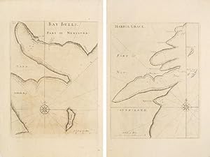
BAY OF BULLS and HARBOR GRACE.
Verlag: London. 1759, 1759
Anbieter: Peter Harrington. ABA/ ILAB., London, Vereinigtes Königreich
Verbandsmitglied: ABA ILAB PBFA
Bewertung:
Two maps, one on either side of a folio leaf, of two harbours in Newfoundland. Compass points, rhumblines and a few soundings on each map. From The English Pilot, the Fourth Book published by Mount & Page. Copper engraving. Uncoloured. Very good condition, a few wormholes on margins. Size: 25 x 33.5 cm.
-
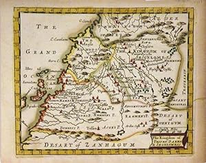
The Kingdom of Tesset Darha & Segelomess
Verlag: J. Seller, London
Anbieter: Argosy Book Store, ABAA, ILAB, New York, NY, USA
Bewertung:
unbound. Miniature map. Copper plate engraving with hand coloring. Image measures 4 3/4" x 5 3/4". This charming miniature map of the Kingdoms of Tesset, Darha and Segelomess covers the northwestern part of Africa includes Morocco and parts of modern day Western Sudan, Algeria and Mauritania. Depicts part of the Barbary Coast including the Canary Islands. Incredibly detailed, the map notes several important cities, towns, waterways and beautifully rendered topography. During this time, the Barbary Pirates operated in this area, despite of which Morocco managed to trade sugar, tobacco, gold and leather with France and England. The map is in good condition with minor toning, especially along the edges. John Seller (c. 1630-1697) was an English instrument maker and cartographer and in 1671 he was appointed Hydrographer to the King. Seller instigated the first English maritime atlas, in an effort to compete with the successful Dutch maps at the time. This map is a nice example of his work.
-
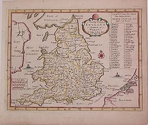
A Traveling Mapp of England & Dominion of Wales
Verlag: John Seller, London, 1670
Anbieter: Argosy Book Store, ABAA, ILAB, New York, NY, USA
Bewertung:
unbound. Zustand: very good. Map. Engraving with early hand coloring. Image measures 4.5" x 6". Nice miniature map of England with part of Ireland, Scotland and Flanders. Includes a gazetteer table and two ships. In excellent condition. John Seller (c. 1630-1697) was an English instrument maker and cartographer and in 1671 he was appointed Hydrographer to the King. Seller instigated the first English maritime atlas, in an effort to compete with the successful Dutch maps at the time. This print was published in "A New Systeme of Geography.", circa 1690. Hard to find.
-
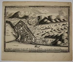
The Royal City of Tangier With the lines And Fortifications when it was Ataqued by the Moores in May 1680
Verlag: London, 1690
Anbieter: Argosy Book Store, ABAA, ILAB, New York, NY, USA
Bewertung:
unbound. Zustand: very good. Samuel Moore (illustrator). Miniature map. Uncolored engraving. Image measures 4 5/16" x 6 3/16". Tangier (in modern day Morocco) controlled entry into the Mediterranean Sea and was the main commercial centre on the North West coast of Africa. It became a British possession in 1661 via the dowry of King Charles II's new wife Catherine of Braganza. Tangier was regularly attacked by Moorish raiders opposed to the British presence. Some toning, otherwise in good condition. John Seller (c. 1630-1697) was an English instrument maker and cartographer and in 1671 he was appointed Hydrographer to the King. Seller instigated the first English maritime atlas, in an effort to compete with the successful Dutch maps at the time. This print was published in "A New Systeme of Geography.", circa 1690.
-
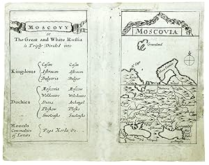
Moscovia.
Verlag: John Seller sold at his house at the Hermitage in Wapping and in Pope's head Alley in Cornhill London, 1678
Anbieter: Shapero Rare Books, London, Vereinigtes Königreich
Verbandsmitglied: ABA ILAB PBFA
Bewertung:

Karte
Engraved map, with the associated description table; centrefold restored, bottom right hand corner re-instated, with small loss. This rare little map, probably taken from an example of Seller's 'Atlas Minimus', began life as a playing card (only one known set), the III of the Europe suit, but was quickly re-engraved to form part of a little pocket atlas, the 'Atlas Minimus' presumably aimed at the education market, perhaps the earliest British cartographic publication so designed. Phillips 490.
-
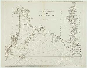
A Chart of the Bay of Galloway and River Shannon.
Erscheinungsdatum: 1748
Anbieter: Altea Antique Maps, London, Vereinigtes Königreich
Verbandsmitglied: ABA ILAB PBFA
Bewertung:
Karte
No Binding. Zustand: Good. London: W. & J. Mount and T. Page, 1748. 435 x 530mm. Narrow top margin. A sea chart covering the north coast of Galway Bay and the River Shannon to Limmerick, orientated with north to the right. Engraved c. 1690, this example was published in Mount & Page's reissue of Seller's 'The English Pilot'.
-
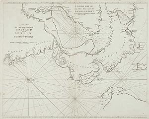
A Chart of the Sea-Coasts of Ireland from Dublin to London-Derry.
Erscheinungsdatum: 1748
Anbieter: Altea Antique Maps, London, Vereinigtes Königreich
Verbandsmitglied: ABA ILAB PBFA
Bewertung:
Karte
No Binding. Zustand: Good. London: W. & J. Mount and T. Page, 1748. 435 x 545mm. Repairs to top margin. A sea chart of the coasts of Ireland from Dublin to Derry, orientated with north to the right. An inset contains a detail ' Lough Foyle or the Passage to London-derry'. Engraved c. 1690, this example was published in Mount & Page's reissue of Seller's 'The English Pilot'.
-
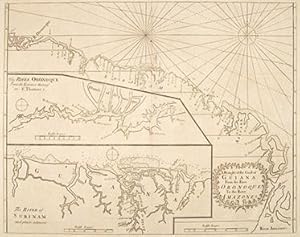
A DRAUGHT of the Coast of GUIANA from the River ORONOQUE, to the River AMAZONES.
Verlag: London. 1759, 1759
Anbieter: Peter Harrington. ABA/ ILAB., London, Vereinigtes Königreich
Verbandsmitglied: ABA ILAB PBFA
Bewertung:
A chart of part of the northern South American coast. Compass point at sea, rhumblines. Two inset maps - one of 'The River Oronoque from the Entrance thereof to St Thomas,' the other of 'The River of Surinam and places adjacent'. Both insets have depth soundings. Cartouche at lower right with title framed by two branches. From The English Pilot, fourth Book by Mount and Page. Copper engraving. Uncoloured. Very good condition, There are a few wormholes, mainly on upper part of map and upper margin Size: 56 x 44.5 cm.
-
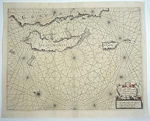
A Chart of the Islands Corfu, Pachsu and Antipachsu with ye Channel and Roads between the Island of Corfu & ye Graetian Coast
Verlag: W & J Mount & T. Page, London, 1747
Anbieter: Antipodean Books, Maps & Prints, ABAA, Garrison, NY, USA
Verbandsmitglied: ABAA ANZAAB ESA ILAB
Bewertung:
Maps. Zustand: Very good condition. An early chart of the Ionian islands and coast of Greece, oriented to the east, showing the coast of Greece at the top of the map, with the islands of Corfu, and the smaller 'Pachsu' (current day Paxos), and 'Antipachsu'. The two smaller islands have been described beautifully and simply: "Paxos is an island of endless olive groves and Anti Paxos one large vineyard". Corfu was named for the beautiful nymph Korkyra, who Poseidon had abducted and brought to the island. Backed on acid free tissue, supporting thinness of the paper near the bottom fold; light color remains on the compass rose and rhumb lines, cartouche and scale at the lower right. Engraved by J. Gascoyne for the "English Pilot" vol 3. Impression mark 21 x 15 3/4" on paper 22 x 18". References: Zacharakis, C. 2156.
-
![Bild des Verkäufers für Moscovia and Russia. [17th Century John Seller Map of Moscow and Russia]. zum Verkauf von Raptis Rare Books](https://pictures.abebooks.com/inventory/md/md30873945407.jpg)
Moscovia and Russia. [17th Century John Seller Map of Moscow and Russia].
Verlag: c. 1685, London, 1685
Rare hand-colored 17th century John Seller Map of Moscow and Russia, from Daniel Fenning's A New System of Geography. One page, with intricate topographical details and hand-colored borders. In near fine condition. Seventeenth century English cartographer, compass maker, and map seller John Seller was appointed hydrographer to the King in March of 1671. In that year he published his first volume of charts and sailing directions, The English Pilot, which would run through many editions until the end of the eighteenth century. The trade in maritime maps and charts had until then been dominated by the Dutch. Seller additionally published several textbooks and nautical almanacs including Practical Navigation (1669) and A Pocket Book Containing Several Choice Collections in Arithmetic, Geometry, Surveying, Dialing, &c. (1677).
-
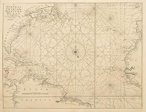
A General Chart of the Western Ocean.
Verlag: London. 1759, 1759
Anbieter: Peter Harrington. ABA/ ILAB., London, Vereinigtes Königreich
Verbandsmitglied: ABA ILAB PBFA
Bewertung:
A Sea Chart of the central Atlantic Ocean, with numerous place names along coast, and all coastal features in detail. Compasses at sea, rhumb lines. From the English Pilot, Fourth Book, published by Mount and Page. Ref: Tooley, Maps and Mapmaking p61 Copper engraving. Uncoloured. Very good condition, some wormholes have been expertly repaired. The map has been remargined. Size: 58 x 46 cm.
-
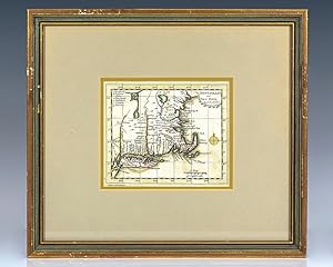
17th Century John Seller Map of New England and New York.
Verlag: Seller, Price & Senex, London, 1703
Rare 17th century John Seller map of New England and New York from Daniel Fenning's A New System of Geography. One page, with intricate topographical details and hand-colored borders, the map displays the eastern portion of New York and New England and includes Long Island, Martha's Vineyard, Nantucket, Block Island, and Rhode Island. In near fine condition. Seventeenth century English cartographer, compass maker, and map seller John Seller was appointed hydrographer to the King in March of 1671. In that year he published his first volume of charts and sailing directions, The English Pilot, which would run through many editions until the end of the eighteenth century. The trade in maritime maps and charts had until then been dominated by the Dutch. Seller additionally published several textbooks and nautical almanacs including Practical Navigation (1669) and A Pocket Book Containing Several Choice Collections in Arithmetic, Geometry, Surveying, Dialing, &c. (1677).
-
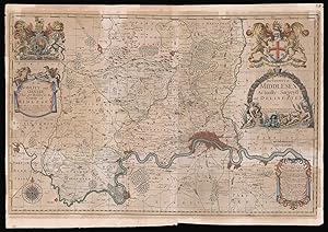
The County of Middlesex Actually Survey'd and Delineated By John Seller. Newley Corrected & Amended with Many Additions. Note that ye uppermost Figures in ye Circles are Computed and the undermost Statute or Measured Miles. A.D. 1710. To the Nobility and Gentry That are Related to the County of Midlesex. This Map is Humbly dedicated by John Seller.
Verlag: Sold by Ric. Davies at the 3 Ink Bottles in Castle Alley at the west end of the Royal Exchange,, [London],, 1710
Anbieter: Daniel Crouch Rare Books Ltd, London, Vereinigtes Königreich
Verbandsmitglied: ABA ILAB PBFA
Bewertung:

Karte
John Seller's rare map of Middlesex Engraved map on two sheets joined, fine original full-wash colour. The map was first issued by Seller in 1679. The map was to be part of Seller's large folio county atlas of England and Wales, entitled 'Atlas Anglicanus'. However the project, like much of Seller's over-ambitious schemes, never got off the ground, with only six of the counties - Middlesex, Surrey, Hertfordshire, Kent, Buckinghamshire, and Oxfordshire - being surveyed. In 1693, he was forced to sell the plates to Philip Lea, who issued them separately and as part of the composite atlases of England and Wales. After Lea's death in 1700, the business was run by his widow Anne, until her death in 1730. How the map came to bear the imprint of Richard Davies is unclear, however, he was known as a co-publisher of several maps and atlases, and he might have come to some agreement with Anne Lea. Scale: 3/4 to 1 statute mile. BLMC Maps 3455.(9.); Skelton 115.
-
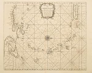
A Correct Chart of the Carribee Islands.
Verlag: London. 1715-50, 1715
Anbieter: Peter Harrington. ABA/ ILAB., London, Vereinigtes Königreich
Verbandsmitglied: ABA ILAB PBFA
Bewertung:
Depicted with north to the right, extending from Puerto Rico to Venezuela, title cartouche at top centre. The map has a compass at sea, rhumb lines, anchorages and depth soundings. It was published in The English Pilot for Mount and Page, in John Seller's fourth book, covering American waters. The atlas was produced and published to counter the prevailing dominance and output of maritime material by the Dutch. Seller began his atlas in the 1670s, and it proved so popular that it ran to over 30 editions, the later ones produced some 100 years later. As a result many charts were re-engraved, or replaced entirely by more accurate examples. Tooley, Maps and Mapmaking p61 Size: 525 x 430 mm. Copper engraving. Uncoloured. Fine condition.
-

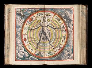
Atlas Coelestis containing the systems and theoryes of the planets the constellations of the starrs. and other phenomena?s of the heavens with nessesary tables relateing thereto?
Verlag: [London: sold by J. Seller, 1677.], 1677
Anbieter: Nigel Phillips ABA ILAB, Chilbolton, Vereinigtes Königreich
Bewertung:

12mo (in 4s), engraved title, 72 pages, and 56 double-page engraved plates (of which 31 are celestial maps). Contemporary mottled calf, very nicely rebacked to match, rear endpapers replaced. Personal library stamp on front endpapers. FIRST EDITION of the first British celestial atlas. John Seller was an important figure in English cartography as he set out to break the monopoly enjoyed by the Dutch in the production of atlases, particularly maritime atlases. Seller overreached himself, however, and later productions were less ambitious; he produced a terrestrial atlas in 1670 (Atlas Minimus), followed by this, the first celestial atlas printed in England, seven years later.The plates show the systems of Ptolemy, Copernicus and Tycho Brahe, maps of the moon and lunar phases, the planets, comets, tables of lunar phases, eclipses, etc, followed by 31 maps of constellations. The plate count varies in descriptions because not all of the plates are counted as double. In this copy all the plates are bound in pairs facing each other; some are clearly printed from one double-page copperplate while at least six are printed from single-page copperplates. Wing S2463.
-
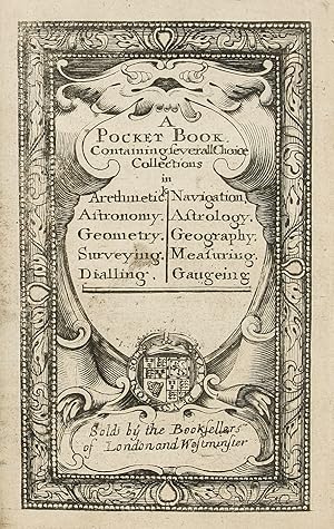
A Pocket Book containing several Choice Collections in Arithmetick, Navigation, Astronomy, Astrology, Geometry, Geography, Surveying, Measuring, Dialling, Gageing.
Verlag: Sold by him [John Seller] at the Hermitage in Wapping and at his Shoop in Pope's head Alley in Cornhill, [1678]., London:, 1678
Anbieter: Daniel Crouch Rare Books Ltd, London, Vereinigtes Königreich
Verbandsmitglied: ABA ILAB PBFA
Bewertung:
Buch
The Wardington "vade-mecum for English gentlemen" Third edition, early issue, 8vo (140 by 85mm), engraved title and 71 plates and tables (some double-page, 3 with moveable volvelles and including 6 maps), coloured in a contemporary hand, 40pp. text, contemporary calf, Pease crests added in gilt, spine repaired at head and foot Seller's Pocket Book is a vade-mecum for English gentlemen, a compendium of useful information for every occasion, with an impressively wide-ranging series of tables including, among others, monthly almanacs, calendars, lists of the Kings of England and Lord Mayors of London, feast days, tables to calculate Easter and the full moon, tables of astronomy, trigonometry, geometry, weights and measures, and even a table to calculate how many bricks would be needed to make a wall. One of the most uncommon of the plates is a double-page engraving explaining Edward Coleman's system of cyphers. Two of the maps are double-page: A Mapp of the World Shewing what a Clock it is (at any time) in any part of the World, and A Traveling Mapp of England. & Dominon of Wales. The world map has an accompanying full-page leaf with rotating overlay, and both seem to have been engraved for use in the Pocket Book. The single-page maps are of the continents (with the Americas on two sheets, North and South America), each with an accompanying engraved table of the divisions (or countries/regions), first prepared for the Book of Geography, and its later edition the Atlas minimus. These maps were also used in editions of Seller's pocket atlases, the New Systeme of Geography [1684, and later], and Atlas Terrestris [ca. 1685, and later]. The Pocket Book is famous for its varied collations; it was first published in 1676 or 1677, and re-issued frequently thereafter to about 1707, with some of the composition due to the whim of the purchaser. For this third edition, the engraved title-page has been re-engraved, inserting Seller's shop address at the Hermitage Stairs in Wapping, with his shop address in Cornhill dateable between 1678 and 1681. This is an early issue of the third edition, with all but one of the monthly almanac leaves in the first state, and without the double-page engraved plates from the Atlas Coelestis [1680], found in other examples of this edition, but with the double-page plate with a table to calculate the day of the new and full moon re-engraved for the years 1680 1700 (but actually only showing 1680 to 1692), this accomplished simply by engraving over the superfluous left hand columns. Provenance: Lord Wardington (1924-2005), bookplate. cf. Shirley, British Library T.SELL-4a; cf. Wing S2480.
-
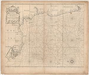
A Chart of the Coast of Guinea from Cape de Verd to Cape Bona Esperanca Drawn with Squares, the side of each Square containing 100 English Leagues
Verlag: ca. 1734]., 1734
Anbieter: Maggs Bros. Ltd ABA, ILAB, PBFA, BA, London, Vereinigtes Königreich
Verbandsmitglied: ABA ILAB PBFA
Bewertung:
Copperplate engraving, 425 x 520 mm. The paper a little soiled. [London : Mount & Page, Uncommon English chart of the much of the western coast of Africa, extending from near Cape Verde to just beyond the Cape of Good Hope. The plate is orientated with north at the left, which allows the coastline to fit neatly onto the plate. The plate was prepared at the end of John Seller's career; it was later used in two volumes of The English Pilot, the Fifth Book for Africa and the Third Book, the Oriental Navigation, this example having been issued in the latter.
-
A Pocket Book. Containing severall choice collections in Arethmetick Astronomy. Geometry. Surveying. Dialling. Navigation, Astrology. Geography. Measuring. Gaugeing. ?
Verlag: [ca. 1707]., 1707
Anbieter: Maggs Bros. Ltd ABA, ILAB, PBFA, BA, London, Vereinigtes Königreich
Verbandsmitglied: ABA ILAB PBFA
Bewertung:
Octavo; engraved title-page, 81, [3]pp.; seventy-three engraved plates, on fortythree single-pages and twenty-five double-page plates, six double-page engraved maps. Recent speckled calf, covers panelled in blind, five raised bands and red morocco label with gilt lettering to spine. [London :] The Booksellers of London and Westminster Rare late edition of Seller?s Pocket Book, seemingly the text block of the Jeremiah Seller and Charles Price sr. printing, but with the title-page re-engraved to erase their imprint. This was presumably done at the end of the Seller and Price partnership, when the partners went bankrupt, circa 1707. The Pocket Book is of notoriously difficult collation; it was first published in 1676 or 1677, and re-issued frequently thereafter to about 1707, with some of the composition due to the whim of the purchaser. It was a handy pocket-sized vademecum for the gentleman. As described on the title-page, there are sections to answer all sorts of problems. The first section, not listed on the title-page, is calendar-related: tables for the twelve months, tables to find Easter Day, the New Moon, the day of the month, a perpetual almanac, sign of the Moon and so on. The other principal grouping in this copy is geometrical and trigonometrical tables and diagrams. At the end is the set of maps of the World and continents, the Americas on two sheets, North and South America; these maps were also used in editions of Seller?s pocket atlases, the New Systeme of Geography [1684, and later], and Atlas Terrestris [ca. 1685, and later]. One of the rarest plates is ?A Generall Description of the several Parts of Fortification? Reference: this edition is unrecorded in ESTC but cf. R16068.
-
The English Pilot, for the Southern Navigation: describing the Sea-Coasts, Capes, Headlands, Bays, Roads, Harbours, Rivers and Ports: together with the Soundings, Sands, Rocks and Dangers on the Coast of England, Scotland, Ireland, Holland, Flanders, Spain, Portugal, to the Streight's-Mouth; with the Coasts of Barbary, and off to the Canary, Madeira, Cape de Verde and Western-Islands.
Erscheinungsdatum: 1758
Anbieter: Maggs Bros. Ltd ABA, ILAB, PBFA, BA, London, Vereinigtes Königreich
Verbandsmitglied: ABA ILAB PBFA
Bewertung:
Folio (475 x 305 mm), [ii], 96pp, 22 engraved charts, most double-page, two engraved text illustrations, many woodcut harbour charts and coastal profiles set in the text. London: Mount & Page [William and John Mount, Thomas Page (II) and Thomas (III)], Uncommon late printing of the 'English Pilot' volume for the 'Southern Navigation', for the use of mariners in European waters, covering the coasts from Scotland southwards, with the Atlantic coasts of Ireland, France and Spain round to the Straits of Gibraltar. This was the principal English pilot book for the region for the period. This copy was published during the Seven Years' War, when fears of a French invasion were at their height, and covers those areas most likely to be the scene of naval actions or landings. The chart composition of the book can vary between copies; this copy is without the chart of the Forth of Forth and two charts of the Dutch coast found in some editions, but has an additional chart of the 'Westerne Islands'. ESTC records three American locations; Adams and Waters add the National Maritime Museum and two further American locations.