Gesamtpreis (1 Artikel Artikel):
Versandziel:

vuillemin alexandre (30 Ergebnisse)
Direkt zu den wichtigsten Suchergebnissen
Produktart
- Alle Produktarten
- Bücher (16)
- Magazine & Zeitschriften
- Comics
- Noten
- Kunst, Grafik & Poster
- Fotografien
- Karten (14)
-
Manuskripte &
Papierantiquitäten
Zustand
Einband
Weitere Eigenschaften
- Erstausgabe
- Signiert
- Schutzumschlag
- Angebotsfoto (25)
Land des Verkäufers
Verkäuferbewertung
-
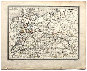
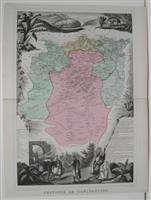
Zustand: Gut. Stahlstichkarte von Zentraleuropa mit leichter Grenzkolorierung im Maßstab ca. 1:7.000.000. Alexandre Vuillemin (1812?1880) war ein bedeutender französischer Kartograph und Herausgeber mit Sitz in Paris. Graveur war Lale, wie am unteren Kartenrand rechts vermerkt ist. Das Blatt ist gedunkelt, leicht verschmutzt,mit kleinen Schäden am unteren Rand. Sprache / Language: fr 1 Seiten. ca. 24,1 x 30 cm.
-
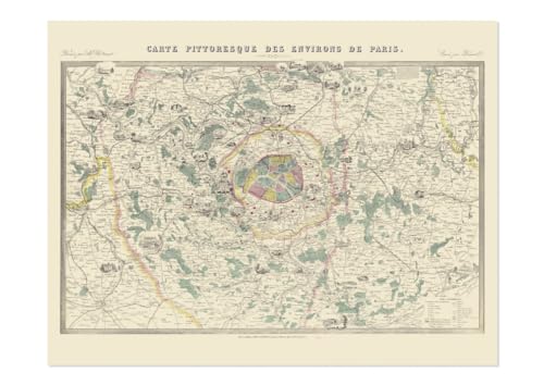
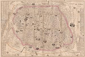
Carte - Carte pittoresque des environs de Paris
Verlag: RELIEFS
ISBN 10: 2380361568ISBN 13: 9782380361568
Buch
Zustand: Neuf.
-
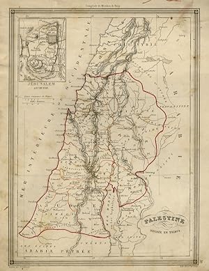
Palestine. Divisée en tribus.
Anbieter: Libreria Oreste Gozzini snc, Firenze, FI, Italien
Bewertung:

[Paris], [J. Langlumč], [c. 1849], carta geografica in litografia, con confini colorati, mm. 262x195 (la carta geografica, compresa la cornice di contorno). Disegnata da Alexandre Vuillemin e litografata da Lale. Proveniente da una edizione dell'Atlas Universel de Geographie Ancienne et Moderne del Vuillemin. Rinforzata al verso con carta nel terzo superiore del foglio.
-
[Paris], [J. Langlumč], [c. 1849], carta geografica in litografia, con confini colorati, mm. 257x195 (la carta geografica, compresa la cornice di contorno). Disegnata da Alexandre Vuillemin e litografata da Lale. Proveniente da una edizione dell'Atlas Universel de Geographie Ancienne et Moderne del Vuillemin. Qualche leggera e piccola macchia.
-
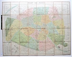
Plan de Paris
Verlag: Lib. Hachette & Cie,. Paris, 1887
Anbieter: Angelika C. J. Friebe Ltd. - MapWoman, Dorking, Vereinigtes Königreich
Bewertung:
Karte
No Binding. Zustand: Very Good. colour printed map; overall map 65,5 x 85 cm, overall paper cover 18 x 11 cm. folds as issued; 32 segments pasted on cloth; some occasional staining; o/w vg cond.- A very detailed folding map of Paris, designed by Vuillemin and engraved by F.Lefevre, showing the 20 arrondissements, with a 80 key legend. The map was published before the installation of the Eiffel Tower in 1887-89.
-

NOUVELLE CARTE Illustrée de L'ITALIE A new illustrated map of Italy presenting divisions of provinces, the substantial physical divisions, and the Geographic distribution of cultivated plants. Industrial towns, the major active mines, railways and routes of canals.
Verlag: Paris. 1857, 1857
Anbieter: Peter Harrington. ABA/ ILAB., London, Vereinigtes Königreich
Verbandsmitglied: ABA ILAB PBFA
Bewertung:
An interesting view of Italy from a commercial and industrial perspective with numerous decorative embellishments. There is statistical information about various parts of Italy on the top and bottom of the map with 8 attractive vignettes depicting fauna, flora, natural treasures, as well as Italian landscapes and architecture of different regions. These include Italy in general, Lombardy, regions of Parma, Modena, Tuscany, Vatican, region of Naples, and St. Marin. Alexandre Vuillemin (1812-1880) was a cartographer and a book editor based in Paris. Despite a prolific cartographic career, much of Vuillemin's life is shrouded in mystery. What is known is that his studied under the prominent French Auguste Henri Dufour (1798-1865). Vuillemin's most important work is his detailed, highly decorative large format Atlas de Géographie Commerciale et Industrielle, which this map is a taken. Size: 600 x 845 mm. Steel engraving. Original outline colour with later additions. Very good condition.
-
Nouveau Plan Illustré de la ville de Paris ave le systéme complet de ses Fortifications et forts Détachés A Paris chez Fatout Boulevard Poissonniere, 17
Verlag: Fatout Boulevard Poissonniere, 17, Paris, 1855
Anbieter: Antiquariat Reinhold Berg eK Inh. R.Berg, Regensburg, Deutschland
Bewertung:

Karte
Other. Copper engraving, hand colored when published. Fine engraved pictorial city plan of Paris, depicting the fortification around various neighborhoods hand colored in outline as published. With an extensive list of street names and places, decorated within the map with fine engraved views of buildings, parks, monuments, etc. In very good to excellent condition. 575 by 835mm (22ľ by 32ľ inches).
-
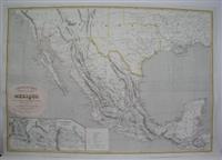
Nouvelle Carte Physique et Politique du Mexique.
Verlag: Garnier Freres, Paris, 1862
Anbieter: Alexandre Antique Prints, Maps & Books, Toronto, ON, Kanada
Bewertung:

Karte
Zustand: Originally folded, very good. Size : 555x800 (mm), 21.875x31.5 (Inches), Original Outline Coloring.
-
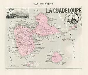
La Guadeloupe
Erscheinungsdatum: 1858
Anbieter: Altea Antique Maps, London, Vereinigtes Königreich
Verbandsmitglied: ABA ILAB PBFA
Bewertung:
Karte
Paris, Combette, 1858. Original colour. 200 x 250mm. Map of Guadeloupe and Marie-Galante, with an inset view of La Soufričr, and a medallion portrait of General Jacques François Dugommier. From Vuillemin's atlas 'La France et ses Colonies'.
-
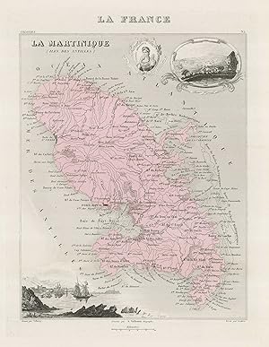
La Martinique (Iles Des Antilles)
Erscheinungsdatum: 1858
Anbieter: Altea Antique Maps, London, Vereinigtes Königreich
Verbandsmitglied: ABA ILAB PBFA
Bewertung:
Karte
Paris, Combette, 1858. Original colour. 270 x 195mm. Map of Martinique, with an inset view of Fort Royal, another of the town of Saint Pierre, and a medallion portrait of Empress Josephine. From Vuillemin's atlas 'La France et ses Colonies'.
-

Le Hassin Houiller Du Pas-De-Calais. T 3 (Ed.1880-1883)
Verlag: HACHETTE LIVRE, 2012
ISBN 10: 2012568785ISBN 13: 9782012568785
Buch
Zustand: New.
-

Le Hassin Houiller Du Pas-De-Calais. T 1 (Ed.1880-1883)
Verlag: HACHETTE LIVRE, 2012
ISBN 10: 2012568769ISBN 13: 9782012568761
Buch
Zustand: New.
-

Le Hassin Houiller Du Pas-De-Calais. T 2 (Ed.1880-1883)
Verlag: HACHETTE LIVRE, 2012
ISBN 10: 2012568777ISBN 13: 9782012568778
Buch
Zustand: New.
-
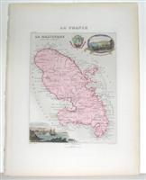
La Martinique (Iles des Antilles)
Verlag: Paris, 1847
Anbieter: Alexandre Antique Prints, Maps & Books, Toronto, ON, Kanada
Bewertung:
Karte
Zustand: Excellent. Size : 224x175 (mm), 8.875x6.875 (Inches), Original Hand Coloring.
-
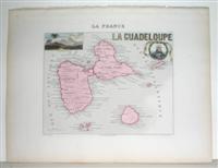
La Guadeloupe
Verlag: Paris, 1847
Anbieter: Alexandre Antique Prints, Maps & Books, Toronto, ON, Kanada
Bewertung:
Karte
Zustand: Excellent. Size : 176x223 (mm), 6.875x8.75 (Inches), Original Hand Coloring.
-

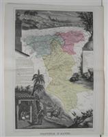
La France. Nouvel atlas illustré des départements et des colonies, dressé d'aprčs les cartes Cassini, du Dépôt de la guerre, des Ponts-et-Chaussées et celles de la Marine.
Verlag: Petit Vanves Migeon, (vers 1860), 1860
Zustand: 8. in-4 oblong, reliure cartonnée, non paginé. Cet atlas classique présente en double page la situation statistique de chaque département et des colonies, avec en regard la carte géographique et ses subdivisions d'arrondissement colorées, soit 100 cartes hors-texte décorées de cartouches gravés en marge qui représentent les armoiries, notabilités et sites remarquables. Bien complet de la carte générale dépliante in-fine (mais déchirure ŕ la pliure), ainsi que de la trčs belle "Carte générale des chemins de fer européens donnant toutes les stations, ainsi que les voies de communication par mer" par A. T. Chartier (93 x 78 cm, petites déchirures). Rousseurs dans la marge des premiers feuillets, manque le faux-titre, titre détaché et reliure trčs usée. A casser ?.
-
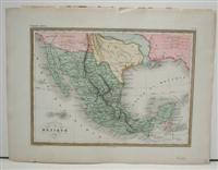
Etats - Unis du Mexique
Verlag: Paris, 1845
Anbieter: Alexandre Antique Prints, Maps & Books, Toronto, ON, Kanada
Bewertung:
Karte
Zustand: Excellent. Size : 220x302 (mm), 8.625x11.875 (Inches), Hand Colored.
-
Province d'Alger
Verlag: Migeon, J, Paris, 1874
Anbieter: Alexandre Antique Prints, Maps & Books, Toronto, ON, Kanada
Bewertung:
Karte
Zustand: Excellent. Size : 423x285 (mm), 16.625x11.25 (Inches), Original Hand Coloring.
-
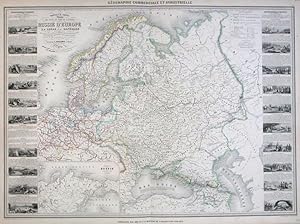
Nouvelle Carte Illustrée des États du Nord de L'Europe donnant la Russie d'Europe, la Sučde et la Danemark.
Erscheinungsdatum: 1860
Anbieter: Altea Antique Maps, London, Vereinigtes Königreich
Verbandsmitglied: ABA ILAB PBFA
Bewertung:
Karte
No Binding. Zustand: Good. Paris, Bula & Delarue, c.1860. Original colour. 640 x 840mm. Detailed map of northern Europe, from Germany to Russia and Georgia, with an illustration illustrative of each country. An inset shows the Russian Empire, including Alaska.
-
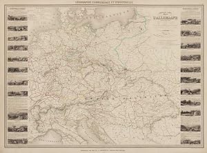
Nouvelle Carte Illustrée de l'Allemagne.
Erscheinungsdatum: 1861
Anbieter: Altea Antique Maps, London, Vereinigtes Königreich
Verbandsmitglied: ABA ILAB PBFA
Bewertung:
Karte
Paris, c.1861. Original colour. 630 x 840mm. Small marginal tear. Detailed map of Germany and the Austrian Empire, encompassing modern Slovakia, Czech Republic, Hungary, Poland, Croatia, Bosnia, Romania, with 22 vignette views and explanatory texts.
-
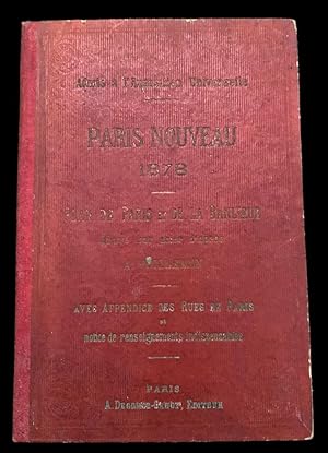
Admis ŕ l'Exposition Universelle, Paris Nouveau 1878, Plan de Paris et de la Banlieue gravé sur acier d'aprčs A. Vuillemin. Avec appendice des Rues de Paris et notice de renseignements indispendables.
Verlag: A Decorge-Cadot Editeur,, Paris,, 1878
Anbieter: Studio Bibliografico Antonio Zanfrognini, Modena, Italien
Bewertung:
In folio grande; 30 pp. ed una grande tavola a colori piů volte ripiegata con l'immagine di Parigi. Due piccoli strappetti senza perdita di carta in corrispondenza delle pieghe della tavola. Legatura editoriale rossa in mezza tela e con cartoncino rigido con titolo, autore ed editore impressi in oro al piatto anteriore. Rarissima edizione della famosa carta di Parigi e delle Banlieue del celeberrimo cartografo francese Alexandre Aimé Vuillemin, edita in occasione dell'Esposizione Universale di Parigi del 1878. Le 30 pagine contengono i nomi di tutte le strade, le "avenues", "boulevards, gallerie, passaggi, piazze, ponti, porte e "poternes", poste, telegrafi, ambasciate, monumenti, fermate del Tramway (sia sud che nord), dei teatri e delle stazioni ferroviarie di Parigi. Alexandre Vuillemin (1812-1880) č stato uno dei piů importante cartografi francesi del XIX° secolo. A fianco dell'attivitŕ di cartografo, portň avanti anche quella di editore. La sede della sua casa editrice si trovava a Parigi. Produttore di numerosi atlanti, le sue mappe sono note per l'uso frequente di ampie illustrazioni a margine della carta vera e propria. Vignette, personaggi famosi e vedute di cittŕ compaiono alternativamente nelle sue carte. Molto si sa della sua produzione cartografica ma assai poco della sua vita privata. E' risaputo che studiň sotto il cartografo francese Auguste Dufour (1798 1865). Le opere piů importanti di Vuillemin sono, certamente, il suo Atlas Illustré de Géographie Commerciale et Industrielle dettagliato e altamente decorativo, nonché i suoi numerosi atlanti francesi anche se enorme successo e numerose ristampe ebbe la sua carta parigina. L'edizione qui presentata della carta di Parigi edita per l'Esposizione Univerale di Parigi del 1878 č una delle piů rare da reperirsi ed ancor piů rara da reperirsi completa della sua legatura originale e del libretto esplicativo. Esemplare in buone condizioni di conservazione.
-
Province de Constantine
Verlag: Migeon, J, Paris, 1874
Anbieter: Alexandre Antique Prints, Maps & Books, Toronto, ON, Kanada
Bewertung:
Karte
Zustand: Very Good. Size : 427x294 (mm), 16.75x11.625 (Inches), Original Hand Coloring.
-
Nouvelle carte illustree de l'Amerique du Nord indiquant les Grandes Divisions Physiques, La Distribution Geographique des vegetaux et des mineraux
Verlag: Paris, 1847
Anbieter: Alexandre Antique Prints, Maps & Books, Toronto, ON, Kanada
Bewertung:
Karte
Zustand: Good. Decrative large map of north America with views and portraits of inhabitants all around, Size : 650x890 (mm), 25.625x35 (Inches), Hand Colored.
-
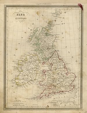
Iles Britanniques Dressees d'apres La Carte Anglaise de Wild par A. Vuillemin, Geographe. [From: Dufour's "Atlas Illustre.". 1846.]
Verlag: Paris. Barbie du Bocage. 1846, 1846
Anbieter: J. Patrick McGahern Books Inc. (ABAC), Ottawa, ON, Kanada
Verbandsmitglied: ABAC ILAB IOBA
Bewertung:
No Binding. Zustand: Near Fine. 33x 25cm, (13.25"x 9.75"), (image 27x 20cm), colour outlines and boundaries, decorative frame borders, French & English scales, index in French, very good to fine. Tooley p.37. A map of old Great Britain by French cartographer Alexandre Vuillemin (1812-1880). Engraved by Charles Smith. "Longitude du Meridien de Paris".
-
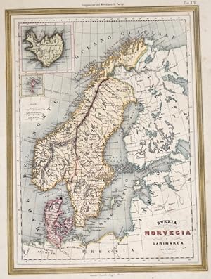
Svezia Norvegia e Danimarca
Verlag: Artist: Vuillemin Alexandre ( - 1880 ) Paris ; issued in: Paris ; ca: 1850; - Alexandre Vuillemin (1812-1880) was a prominent 19th century French cartographer and editor based in Paris He produced a number of atlases and his maps are noted for the frequent use of extensive margin illustrations ? vignettes famous people and views of cities His atlases were popular and many went through multiple editions Despite a prolific cartographic career not a lot is known of Vuillemin's life He studied under the French cartographer Auguste Dufour (1798 - 1865)and his atlases and maps are held by and available through many collections including the British Museum, 1812
Anbieter: Antique Sommer& Sapunaru KG, München, Deutschland
Bewertung:
Technic: Lithography; colorit: original colored; condition: Some stains, size (in cm): 31 x 22,5; - Map shows the Scandinavian Peninsula with Norway, Sweden, Denmark, the northwestern area of Finland and insets maps of Iceland and the Faroe Islands.
-
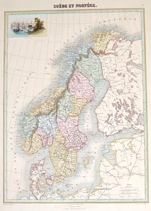
Sučde et Norvége.
Verlag: Artist: Vuillemin Alexandre ( - 1880 ) Paris ; issued in: Paris ; ca: 1850; - Alexandre Vuillemin (1812-1880) was a prominent 19th century French cartographer and editor based in Paris He produced a number of atlases and his maps are noted for the frequent use of extensive margin illustrations ? vignettes famous people and views of cities His atlases were popular and many went through multiple editions Despite a prolific cartographic career not a lot is known of Vuillemin's life He studied under the French cartographer Auguste Dufour (1798 - 1865)and his atlases and maps are held by and available through many collections including the British Museum, 1812
Anbieter: Antique Sommer& Sapunaru KG, München, Deutschland
Bewertung:
Technic: Lithography; colorit: original colored; condition: Perfect condition, size (in cm): 40 x 27,5; - Map shows the Scandinavian Peninsula with Norway, Sweden, Denmark, the northwestern area of Finland and a view of the city of Stockholm.
-
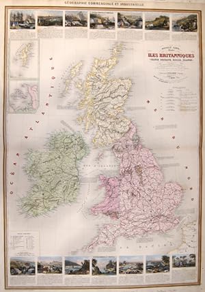
Nouvelle Carte Illustree des Iles Britanniques
Verlag: Artist: Vuillemin Alexandre ( - 1880 ) Paris ; issued in: Paris ; ca: 1840; - Alexandre Vuillemin (1812-1880) was a prominent 19th century French cartographer and editor based in Paris He produced a number of atlases and his maps are noted for the frequent use of extensive margin illustrations ? vignettes famous people and views of cities His atlases were popular and many went through multiple editions Despite a prolific cartographic career not a lot is known of Vuillemin's life He studied under the French cartographer Auguste Dufour (1798 - 1865)and his atlases and maps are held by and available through many collections including the British Museum, 1812
Anbieter: Antique Sommer& Sapunaru KG, München, Deutschland
Bewertung:
Technic: Lithography; colorit: original colored; condition: Perfect condition, size (in cm): 86 x 59,5; - Map depicts Great Britain or the Channel Islands, on intet maps the Shetland Islands. The map shows all railways in Great Britain with 14 views and its history.
-
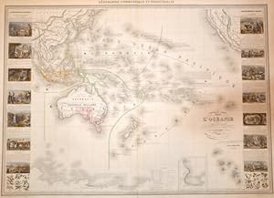
Nouvelle Carte illustrée l' Oceanie
Verlag: Artist: Vuillemin Alexandre ( - 1880 ) Paris ; issued in: Paris ; ca: 1860; - Alexandre Vuillemin (1812-1880) was a prominent 19th century French cartographer and editor based in Paris He produced a number of atlases and his maps are noted for the frequent use of extensive margin illustrations ? vignettes famous people and views of cities His atlases were popular and many went through multiple editions Despite a prolific cartographic career not a lot is known of Vuillemin's life He studied under the French cartographer Auguste Dufour (1798 - 1865)and his atlases and maps are held by and available through many collections including the British Museum, 1812
Anbieter: Antique Sommer& Sapunaru KG, München, Deutschland
Bewertung:
Technic: Steel engraving; colorit: colored; condition: Very good, size (in cm): 60 x 84; - map of the Pacific Ocean with Australia and New Zealand with pictures and explanations to the islands and surrounding countries.
-
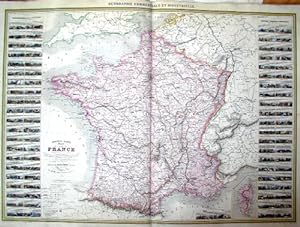
Nouvelle Carte illustre de la France.
Verlag: Artist: Vuillemin Alexandre ( - 1880 ) Paris ; issued in: Paris ; dated: 1857; - Alexandre Vuillemin (1812-1880) was a prominent 19th century French cartographer and editor based in Paris He produced a number of atlases and his maps are noted for the frequent use of extensive margin illustrations ? vignettes famous people and views of cities His atlases were popular and many went through multiple editions Despite a prolific cartographic career not a lot is known of Vuillemin's life He studied under the French cartographer Auguste Dufour (1798 - 1865)and his atlases and maps are held by and available through many collections including the British Museum, 1812
Anbieter: Antique Sommer& Sapunaru KG, München, Deutschland
Bewertung:
Technic: Steel engraving; colorit: original colored; condition: Very good, size (in cm): 62 x 83; - Map shows total France with 86 views at the border with the former provinces and a description of their structure and population, on a seperate map showing Corsica.
-
Atlas Historique, Genealogique, Chronologique, Et Geographique
Verlag: Paris, De Sourdon, o.J. (um 1810), 1810
Anbieter: Bachmann & Rybicki UG haftungsbeschränkt, Dresden, Deutschland
Bewertung:
2°(53x20cm), 2 nn. Bll., 33 doppelblattgroße, mehrfach gefaltete Karten, Hldr. d. Zt NA - Enthält Erläuterungen zu kaiserlichen Dynastien um 1808, dem Zustand von Europa um 1808, sowie der napoleonischen Pracht und der geografischen Geschichte Europas. - Einband etwas berieben und bestoßen, Rücken und Deckel mit goldgepr. Titel. Papier etwas gebräunt, teils etwas braunfleckig. Exlibris auf vorderem Spiegel, Spiegel u. Vorsatzbl. mit hs. Notizen, Karten hs. nummeriert, Titelbl. im Falz ca. 15cm eingerissen.