Gesamtpreis (1 Artikel Artikel):
Versandziel:

wallis edward (19 Ergebnisse)
Direkt zu den wichtigsten Suchergebnissen
Produktart
- Alle Produktarten
- Bücher (12)
- Magazine & Zeitschriften
- Comics
- Noten
- Kunst, Grafik & Poster
- Fotografien
- Karten (6)
-
Manuskripte &
Papierantiquitäten (1)
Zustand
Einband
Weitere Eigenschaften
Gratisversand
Land des Verkäufers
Verkäuferbewertung
-
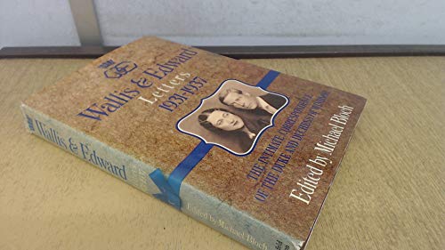
Wallis & Edward : letters, 1931-1937 : the intimate correspondence of the Duke and Duchess of Windsor
Verlag: Weidenfeld & Nicolson, 1986
ISBN 10: 0297788043ISBN 13: 9780297788041
Anbieter: Wonder Book, Frederick, MD, USA
Bewertung:

Buch
Zustand: Very Good. Very Good condition. Good dust jacket. A copy that may have a few cosmetic defects. May also contain a few markings such as an owner's name, short gifter's inscription or light stamp.
Mehr Angebote von anderen Verkäufern bei ZVAB
Gebraucht ab EUR 6,06
-
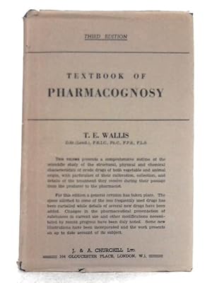
Textbook of Pharmacognosy
Verlag: J. & A. Churchill, 1955
Anbieter: World of Rare Books, Goring-by-Sea, SXW, Vereinigtes Königreich
Bewertung:
Zustand: Good. 1955. Third Edition. 578 pages. Brown dust jacket over blue cloth. Contains black and white in-text illustrations. Prize plate stuck to front pastedown. Pages are lightly tanned and foxed throughout. Occasional thumb-marking present. Previous owner's inscription to front free endpaper. Binding is slightly shaky. Boards have mild edge wear with slight rubbing to surfaces. Soft crushing to spine ends. Light tanning to spine and edges. Unclipped jacket has moderate edge wear with chips, tears and creasing. Moderate tanning to spine and edges. Some scuffed marking to surfaces.
-
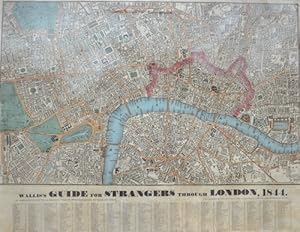
Wallis's Guide for Strangers through London, 1844.
Verlag: Artist: Wallis Edward ; issued in: London ; ca: ; -, 1844
Anbieter: Antique Sommer& Sapunaru KG, München, Deutschland
Bewertung:

Technic: Lithography; colorit: original colored; condition: Some folds smoothed, size (in cm): 54 x 71 cm; - Detaied city map of London depicting all streets and important buildings.
-
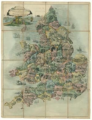
Wallis's Picturesque Round Game of the Produce & Manufactures, of the Counties of England & Wales.
Erscheinungsdatum: 1830
Anbieter: Altea Antique Maps, London, Vereinigtes Königreich
Verbandsmitglied: ABA ILAB PBFA
Bewertung:
Karte
London: Edward Wallis, c.1830. Original colour. Aquatint, dissected and laid on linen as issued, 670 x 510mm. Slight soiling. An educational ''goose game'', in which players race counter-clockwise around England and Wales, starting in the Thames Estuary and ending at London, through 151 places. The counties are delineated, with little vignettes illustrating the main features of the area, both commercial (barrels of beer at Dorchester) and topgraphical (Stonehenge in Wiltshire).
-
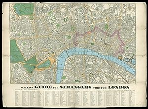
Wallis's Guide for Strangers through London.
Verlag: Published by E. Wallis, 42, Skinner Street, [c.1840]., [London],, 1840
Anbieter: Daniel Crouch Rare Books Ltd, London, Vereinigtes Königreich
Verbandsmitglied: ABA ILAB PBFA
Bewertung:

Karte
The first steam railway to have a terminus in the capital Engraved plan, fine original hand-colour, alphabetical list of streets below, old folds reinforced, some with minor loss. Wallis's Guide for Strangers was a popular map, printed in numerous editions between 1813 and 1843. This edition shows the London and Greenwich Railway, opened between 1836 and 1838, which terminated at London Bridge, and was the first steam railway to have a terminus in the capital. Also shown is the London and Blackwall line, opened on July 6, 1840. This terminates at Minories on the current map, but was extended to Fenchurch Street in 1841. The London and Birmingham Railway was the first intercity line to be built into London. It terminates at Euston Station, which on this map is named as the Birmingham Railway Depot, and ran from 1833 to 1846, when it became part of the London and North Western Railway Line. Lastly is the Eastern Counties Railway, opened June 20, 1839. In July of 1840, it was extended to run from Shoreditch, as shown on this map, to Brentwood. In addition to selling maps and charts, Edward Wallis, with his father John, was the most prolific publisher of educational board games. His father was the inventor of the jigsaw puzzle. Although not dated, the plan can be dated to 1840 due to the Eastern Counties Railway to Shoreditch (1840), and London & Blackwall to Minories (1840). This would place it between states (8) and (9) in Howgego. Scale: 6 inches to one statute mile. Howgego 301 (intermediate state between 8 and 9).
-

REPUBLIC OF TEXAS. COUNTY OF [SHELBY]. I [EDWARD WALLIS] DO SOLEMNLY SWEAR, THAT I WAS A RESIDENT CITIZEN OF TEXAS, AT THE DATE OF THE DECLARATION OF INDEPENDENCE. [followed by five lines of text]
Verlag: Shelby Co., Republic of Texas, 1838
Anbieter: Bartleby's Books, ABAA, Chevy Chase, MD, USA
Verbandsmitglied: ABAA ESA ILAB IOBA
Bewertung:
Signiert
Partly printed document, completed in manuscript. 12 x 19 cm. Horizontal fold, some scattered foxing and toning, a few shallow chips to right margin. Edward Wallis declares he was a resident of the Republic of Texas in 1836, and that he "did not leave the country during the campaign of the Spring of 1836 to avoid a participation in the struggle, that I did not refuse to participate in the War, that I did not aid or assist the enemy." Wallis was applying for his quantum of land by rights of his said residency, as allowed under the Constitution and laws of the Republic of Texas. Signed by Wallis, and witnessed by G.V. Lusk, Chief Justice and Notary Public of the County. Three other names appear in ink on the verso: Wm. Daniel, F.L. Green, and Jordan Smith. The Republic of Texas declared itself to be an independent, sovereign state on March 2, 1836. Delegates to the 1836 convention quickly drafted a Constitution which included a provision whereby all citizens residing in the state at the time of independence [African Americans and Native Americans excepted] could receive a portion of land in the state "in like manner as colonists. every head of a family shall be entitled to one league and labor of land, and every single man of the age of seventeen and upwards, shall be entitled to the third part of one league of land." Any citizen who left the Republic "for the purpose of evading a participation in the present struggle" would forfeit his rights of citizenship and land. The convention also required their male citizens ages 17 to 50 to serve in the military, offering land bounties of 320 to 1280 acres as incentives.
-
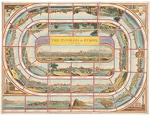
The Panorama of Europe. a New Game.
Erscheinungsdatum: 1815
Anbieter: Altea Antique Maps, London, Vereinigtes Königreich
Verbandsmitglied: ABA ILAB PBFA
Bewertung:
Karte
London: J. & E. Wallis, & Sidmouth, J. Wallis Jun.r, 1815. Original colour. Dissected and laid on linen, as issued, sheet 475 x 630mm, folded into original slipcase with illustrated title label. Wear to slipcase. The players use a 'totum' and 'pyramids or travellers' to compete: players take turns to roll the totum and move through 40 cities from Oporto to London. 35 of the cities are in a spiral, including Malta, Constantinople, Moscow, and Edinburgh, ending with a large view of London in the centre; numbers 36-39 are in the corners, with Rome, a view of The Monument in London, Paris and St Petersburgh, all unnamed.
-
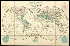
Wallis's New Game, Exhibiting a Voyage round The World.
Verlag: Published by E. Wallis, 42 Skinner Street and 12 High Street, Islington, [c1823]., London,, 1823
Anbieter: Daniel Crouch Rare Books Ltd, London, Vereinigtes Königreich
Verbandsmitglied: ABA ILAB PBFA
Bewertung:
Karte
A Voyage round the World Engraved game map with hand colour, dissected and mounted on linen, folding into original cloth slipcase, lettered in gilt. Wallis first published a game of this nature in 1796 (see Whitehouse facing p.7 for an illustration), by the 1820's a number of new discoveries had been incorporated together with other refinements made to the game itself. The sheet contains the world in two conjoined hemispheres with 5 additional hemispheres around the outside consisting of 'Geographical Circles,' 'Zones, ' 'Parallels of Latitude,' 'Meridians,' and an 'Explanation of Geographical Characters.' The players circumnavigate the world traveling east around Africa, through India, 'New Holland' then north to China and Japan, then south through North and South America, west to New Zealand the Pacific Islands before crossing back to the South Atlantic and returning to port in London.
-
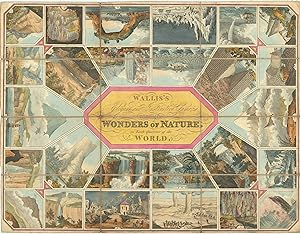
Wallis's Elegant and Instructive Game Exhibiting the Wonders of Nature, in Each Quarter of the World.
Verlag: London, Edward Wallis, [1818]., 1818
Anbieter: Antiquariat INLIBRIS Gilhofer Nfg. GmbH, Vienna, A, Österreich
Verbandsmitglied: ILAB VDA VDAO
Bewertung:
Hand-coloured copper engraving mounted on canvas in 12 segments (620 x 470 mm). With accompanying pamphlet: 8vo. 20 pp. Contemporary plain brown wrappers. All housed in original marbled box with coloured and mounted illustration on the front. A fascinating Regency-era tabletop game featuring hand-coloured copper engravings of famous (and dangerous) landmarks to stir the imaginations of British armchair adventurers. The gameboard consists of twenty-six sections depicting various natural wonders, through which a player must move, facing hazards along the way. The accompanying booklet contains not only the game instructions, but also an educational description of each such danger: if one lands on the "earthquake" section, one must "Stop a turn to lament this", whereas landing on the "pillars of burning sand, in the deserts of Arabia" ends one's game entirely. These so-called sand pillars are in fact enormous dust devils, and in Arab countries they are attributed to the djinn, the spirit race that lives alongside humans but are rarely seen. Although the first stories about them are older than Islam, djinn are mentioned in the Qur'an, which states that they are created from smokeless fire, and like mankind can be both good and evil (in Egypt they are known as "fasset el 'afreet", or ghost winds). - The various wonders depicted include Mount Etna in Sicily, Poole Cave in Derbyshire, the emergence of a volcano in the Atlantic Ocean near the island of Săo Miguel in the Azores, ice mountains at the North Pole, the basalt columns on the island of Staffa in the Hebrides archipelago, the Antiparos Cave in Greece, the Pico del Teide on the island of Tenerife, the Devil's Bridge in Switzerland, Niagara Falls, a waterfall on the White River in Jamaica, the Maelstrom on the Lofoten Islands in Norway and bubbling springs in the town of Geysir in Iceland. In its section on Mt. Etna, the booklet states that an eruption of 1669 wiped out 5,000 houses and formed a huge mountain two miles in circumference. In the section on earthquakes, the author describes the infamous and deadly Lisbon Earthquake of 1755 that flattened most of the city, at the time a thriving metropolis of 70,000 inhabitants. - Edward Wallis was the son of John Wallis (d. 1818), the most prolific publisher of board games in the late 18th and early 19th centuries; both of his sons continued his work. - Booklet a little browned due to paper stock, with a short tear to the wrappers. Board somewhat browned in the margins; overall well preserved, especially the colours, which remain bright.
-
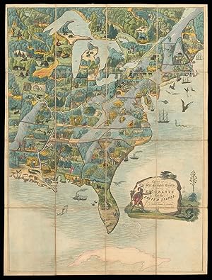
Game of the Star-Spangled Banner.
Verlag: E. Wallis, Skinner St, [c1842]., London,, 1842
Anbieter: Daniel Crouch Rare Books Ltd, London, Vereinigtes Königreich
Verbandsmitglied: ABA ILAB PBFA
Bewertung:
Karte
One of the earliest game maps featuring the United States Hand coloured engraved map with aquatint, dissected and mounted on linen. Wallis's rare and entertaining map of the United States. This scarce and beautiful instructional game was to be played as a lotto, each player moving around the finely detailed map which is crowded with vignettes of American life and wildlife. 'It is probably the earliest game to utilise a map of the United States' (Whitehouse). The game aimed to teach an English audience about the United States, some of the descriptions in the rule book - present in the British Library copy, however not sold with the current example - must have astounded the young players, with the entry on Arkansas restricted to the "lynch law", and a number of references to slavery including, "The slave-holders of the southern states are extensively supplied from the markets of Virginia, where negroes are reared for the purpose of sale and traffic. the last taint of negro blood subjects an individual to this degraded condition". Some of the descriptions of American Wildlife too, must have been alarming, such as that of the Turkey Buzzard, "this bird feeds on carrion, and if attempted to be taken, vomits the contents of its stomach in the face of its pursuer, emitting the most intolerable stench"; and the Grizzly Bear, "The largest and fiercest animal on this continent. His very name is dreadful, as his disposition is bloodthirsty". Games of this period are rare, particularly in such fine condition. The map serves as the frontispiece for Whitehouse's reference book on table games. Whitehouse p. 44.
-

An Atlas of Dental Extractions With Notes on the Causes and Relief of Dental Pain
Verlag: LIGHTNING SOURCE INC, 2021
ISBN 10: 1013954955ISBN 13: 9781013954955
Buch
Zustand: New.
-

Die Windsors. Briefe einer großen Liebe
Verlag: Droemer Knaur, 1986
ISBN 10: 3426262924ISBN 13: 9783426262924
Buch
Befriedigend/Good: Durchschnittlich erhaltenes Buch bzw. Schutzumschlag mit Gebrauchsspuren, aber vollständigen Seiten. / Describes the average WORN book or dust jacket that has all the pages present.
-
Wallis s New Game, exhibiting a Voyage round The World.
Verlag: E.Wallis, 42 Skinner Street, and 12 High Street, Islington London, 1820
Anbieter: Angelika C. J. Friebe Ltd. - MapWoman, Dorking, Vereinigtes Königreich
Bewertung:
Karte
No Binding. Zustand: Very Good. copper engraved map with original colour, pasted onto linen in 10 segments. overall 40 x 61 cm, segment 20 x 12 cm. paper slightly toned; some light soiling; pin holes in all four corners; 2 paper slips pasted on verso. No slipcase.- Decorative double hemispherical board game of a voyage around the World, starting in the British Isles (the earliest number is 6 in Dublin) and finishing in London (no. 120). The race crosses over to Europe, then around West and South Africa, North Africa and Arabia, across Persia and Russia, via India, South East Asia, Australia with Van Diemens Island and Port Jackson as stops, New Guinea, China, Japan, Kamschatka, Arctic Highlands, Canada. Onto North, Central and South America, crossing over to New Zealand, passing various islands in the Pacific, before crossing over to the Sandwich Islands, passing the Canary Islands and Azores and ending up in London.- The hemispheres are surrounded by five further hemispheres: 'Geographical Circles,' 'Zones, ' 'Parallels of Latitude,' 'Meridians,' and an 'Explanation of Geographical Characters.'- Wallis first published similar games in 1796 but with new discoveries, the boards were being updated and refined. He was the son of John Wallis, the earliest and leading English game-maker; as the oldest son, he stood to inherit the family business.- NB: it is very rare to find early board games that mention Australia!.
-

An Intermediate Course of Laboratory Work in Chemistry
Verlag: LIGHTNING SOURCE INC, 2021
ISBN 10: 1014729823ISBN 13: 9781014729828
Buch
Zustand: New. KlappentextThis work has been selected by scholars as being culturally important and is part of the knowledge base of civilization as we know it.This work is in the public domain in the United States of America, and possibly ot.
-
Scarce card signed by both
Anbieter: Andreas Wiemer Historical Autographs, Kelkheim, Deutschland
Bewertung:
Manuskript / Papierantiquität Signiert
Kein Einband. Zustand: Sehr gut. Edward VIII. (1894-1972) & Simpson, Wallis (1896-1986) - Scarce card signed by both - Edward VIII. - King of Great Britain and Ireland, reigned from January to December 1936. Wallis Simpson - an American socialite. Card signed by both "Edward Duke of Windsor" and "Wallis Windsor" in blue ballpoint pen. Card, 5.25 x 3.0 inch (visible), n.p., n.d. (1956 May 8 stamp at the top right corner), blue embossed coat of arms. Fine condition. Handsomely matted in gray with a glossy photograph of Edward and Wallis to an overall of 7.75 x 11.75 inch. Both items removable affixed with photo corners. Excellent display item. COMES WITH A CERTIFICATE OF AUTHENTICITY BY ANDREAS WIEMER HISTORICAL AUTOGRAPHS. Please do not hesitate to contact me with any questions. Signatur des Verfassers.
-
ORIGINAL PATENT APPLICATION NUMBER 993,404 FOR IMPROVEMENTS IN OR RELATING TO LACE MACHINES. (NOTTINGHAM).
Verlag: HMSO, 1962
Anbieter: Cambridge Rare Books, Cambridge, GLOUC, Vereinigtes Königreich
Bewertung:
Erstausgabe
PAPERBACK. Zustand: GOOD. 1st Edition. 1962. HMSO. First. Disbound loose sheets with clear protective covers. 7.5.x11. Complete specification for patent application together with drawings.
-
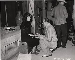
The Woman in the Window (Two original photographs from the 1944 film noir)
Verlag: N.p., N.p., 1944
Two vintage photographs from the set of the 1944 film noir, one showing director Fritz Lang closely inspecting a filmstrip, the other showing Lang in conversation with actress Joan Bennett. Based on J. H. Wallis' 1943 novel "Once Off Guard." A married psychology professor gets mixed up with a beautiful young woman who plunges him into a world of blackmail and murder. One 9.5 x 7.5 inches, one 8 x 10 inches. Near Fine. Grant US. Selby US Masterwork. Silver Classic Noir. Spicer US.
-
[Edwardian paediatric dentistry.] Four pamphlets: Rev. J. O. Bevan, 'Dental Hygiene'; G. Cunningham, 'What the Dentist can do for the State'; C. Edward Wallis, 'The Care of Teeth in Public Elementary Schools'; British Dental Association, 'Memorandum'
Verlag: All London two by John Bale & Sons one for British Dental Association London 1906 1908 and undated, 1896
Anbieter: Richard M. Ford Ltd, London, Vereinigtes Königreich
Bewertung:
Four pamphlets. Three with red labels of the Board of Education Reference Library, London, and all four bearing its stamps and shelfmarks. All in good condition, lightly aged and worn. All now scarce. ONE: Rev. J. O. Bevan, M.A., F.S.A. - Dental Hygiene, Especially in Relation to Children and Schools. ('To be obtained from the author, 55, Gunterstone Road, West Kensington, London, W.' No date.) 8pp, 12mo. Stapled into grey printed wraps. No copy on OCLC WorldCat or on COPAC. TWO: British Dental Association, - Memorandum in regard to the Condition of the Teeth of School Children [ ] and Report of the Inter-Departmental Committee on Physical Deterioration. (Printed for the British Dental Association, London, by John Bale, Sons, & Danielsson, Ltd., London. [1905.]) 70pp, 12mo. In grey printed wraps. With fold-out specimen of chart. THREE: G. Cunningham, M.A. Cantab., L.D.S. England, D.M.D. Harv. What the Dentist can do for the State. ('Reprinted from the "Journal of the British Dental Association," April, 1896. London: John Bale & Sons, 1896.) 16pp, 12mo. Stapled into pink printed wraps. Only two copies on OCLC WorldCat, and none on COPAC. FOUR: C. Edward Wallis, M.R.C.S. England, L.R.C.P. England, L.D.S. England. The Care of Teeth in Public Elementary Schools | With Special Reference to what is being done in Germany | With Specimen of Chart used in the Dental Examination if the L.C.C. Michael Faraday School, designed by the Author'. (Issued by the Medical Officers of Schools Association. London: J. & A. Churchill, 1908.) 14pp, 12mo. With three pages of plates, including four photographs from the 'Darmstadt School-Denistry'. Stapled into blue printed wraps. The 'Specimen of Chart' (1p, 8vo), headed 'London County Council. | DENTAL RECORD.', is printed on one side of a piece of blue paper, folded, and tipped-in inside the front cover.