Gesamtpreis (1 Artikel Artikel):
Versandziel:

washington government printing office (5 Ergebnisse)
Direkt zu den wichtigsten Suchergebnissen
Produktart
- Alle Produktarten
- Bücher (4)
- Magazine & Zeitschriften
- Comics
- Noten
- Kunst, Grafik & Poster
- Fotografien
- Karten (1)
-
Manuskripte &
Papierantiquitäten
Zustand
- Alle
- Neu
- Antiquarisch/Gebraucht
Einband
- alle Einbände
- Hardcover (3)
- Softcover
Weitere Eigenschaften
- Erstausgabe
- Signiert
- Schutzumschlag
- Angebotsfoto (2)
Land des Verkäufers
Verkäuferbewertung
-

Heads of Families ath theFirst Census of the United States 1790: New Hampshire
Verlag: Accelerated Indexing Systems, Inc.
Anbieter: Powell's Bookstores Chicago, ABAA, Chicago, IL, USA
Bewertung:

Zustand: Used - Very Good. 1978. Paper in clear plastic binder, quarto, 146 pp. Reprinted from 1907 edition. Very Good.
-
Acts and Resolutions of the United States of America, Passed at the Second Session of the Thirty-Ninth Congress, and at the First Session of the Fortieth Congress, December 3, 1866-March 27, 1867
Verlag: Washington Government Printing Office, 1867
Zustand: Fair. This is an ex-library book and may have the usual library/used-book markings inside.This book has hardback covers. In fair condition, suitable as a study copy. No dust jacket. Quarto. Pamphlet rebound in red cloth covers with gilt lettering on backstrip. Original pamphlet cover brown, stained and slightly torn at edges. Slight foxing. Age-toned pages. Stained pages. Normal binding. Name written on pamphlet cover in pen, 'Victor K. McElheny.' Please note the Image in this listing is a stock photo and may not match the covers of the actual item,650grams, ISBN:
-
Acts and Resolutions of the United States of America, Passed at the Third Session of the Fortieth Congress and the First Session of the Forty-First Congress, December 7, 1868-April 10, 1869
Verlag: Washington Government Printing Office, 1869
Zustand: Fair. This is an ex-library book and may have the usual library/used-book markings inside.This book has hardback covers. In fair condition, suitable as a study copy. No dust jacket. Quarto. Pamphlet rebound in red cloth covers with gilt lettering on backstrip. Original pamphlet cover brown, stained and slightly torn at edges. Slight foxing. Age-toned pages. Stained pages. Normal binding. Name inscribed on pamphlet cover, 'Victor K. McElheny.' Please note the Image in this listing is a stock photo and may not match the covers of the actual item,550grams, ISBN:
-
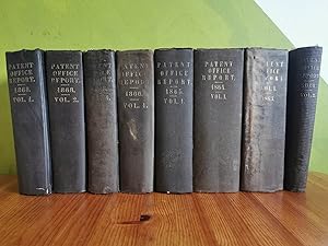
Hardcover. Zustand: Gut. Weight - 10 kg Patent Office Report : 1861 (vol.2) page - 440 1863 (vol.1) page - 895 1864 (vol.1), page - 1073 1865 (vol.1) , page - 562 1866( vol.1) page -688 1868 (vol.1) page - 880 (vol.2) page - 817 (vol.4) page - 809.
-
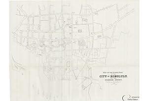
HONOLULU, HAWAII: MAP OF THE LOWER PART OF THE CITY OF HONOLULU AND THE HARBOR FRONT. COMPILED FROM OFFICIAL MAPS BY A.B. LOEBENSTEIN. 1893.
Anbieter: Antiquariat Dasa Pahor GbR, München, Deutschland
Bewertung:

Karte
This large map is the most authoritative map of Downtown Honolulu made during the 1890s, a heady period that saw the American backed coup d'état that overthrew the Hawaiian Royal government (1893) and the U.S. annexation of the islands (1898). The map shows all of the city's streets and hints at its innumerable alleyways, while outlining all of its major buildings including: Alholani Hale (the legislature, built in 1874), the Customs House, Music Hall, the Honolulu Market, the former Royal Palace (occupied until January 1893 by Queen Liliuokalani), Armory, Catholic Church, Post Office, while along the harbor front are the headquarters of several corporations and shipping offices. On the west side of the harbor is the 'Oahu Railway Land Co. Railway Wharf', the seaside terminus of Hawaii's first railway, a line commenced in 1889, which by this time extended only 18.5 miles. The map also shows that the results of the large land reclamation project forming the Waikahalulu-Esplanade area, the wth of Halekauwila Street. Since the late 1850s, work had been underway to reclaim the area, and the map shows that the work was, by this time, largely complete. The details surrounding the publication of the map are often given incorrectly or left vague. In truth, the map was published tipped in to a rare congressional report entitled U.S. 53rd Congress. 2nd Session. House of Representatives. Execute Document No. 47 (Washington, D.C., December 18, 1893). The repost is considered the be a highly important source on the January 1893 American-backed coup d'état that toppled the Hawaiian royal government, and includes an address to Congress by President Grover Cleveland and the 'Blount Report,' which describes many details of the coup. The map was therefore published late in 1893 in Washington, D.C., by the U.S. Government Printing Office. The map was compiled by the prominent civil engineer A.B. Loebenstein from the best official sources, in an effort to set the scene for the report wt of the draments which had recently transpired in Honolulu. Albert Braun Loebenstein (1857 1907) was a prominent figure in Annexation Era Hawaii. Born in New York City in 1857, he was educated as a civil engineer and emigrated to the Kingdom of Hawaii in the 1880s. Based in Hilo, on the Big Island, he became a leading land surveyor and maintained a lucrative private consulting business. Loebenstein received important contracts from the American junta, which controlled Hawaii following the coup that overthrew the royal regime in January 1893. He was charged with surveying many of the large government land holdings on various islands. His most important public project was an 1898 plan for the redevelopment of Honolulu Harbor. He also conducted numerous cadastral surveys for private clients. Loebenstein was also a controversial political operator, who while executing contracts for the American junta, was known to harbor sympathies for the former royalist regime. He went on to oppose e U.S. Annexation ofawaii in 1898. In spite of this, following annexation, he was elected to the Hawaiian Territorial Legislature, whereupon he played a prominent role in the islands' affairs until his death. The map is rare and is one of the earliest obtainable maps of Honolulu. References: David W. Forbes, Hawaiian National Bibliography, 1780 1900: 1881 1900 (Honolulu, 1998), no. 4518 (p. 519); Library of Congress: G4384.H6.